Past IEM Features tagged: winter1819
The IEM generates per winter storm analyses of snowfall reports over Iowa and tags them by the winter season. Here are the tags used for the previous winter seasons that these maps are available for:
- Winter 2010-2011
- Winter 2011-2012
- Winter 2012-2013
- Winter 2013-2014
- Winter 2014-2015
- Winter 2015-2016
- Winter 2016-2017
- Winter 2017-2018
- Winter 2018-2019
- Winter 2019-2020
- Winter 2020-2021
- Winter 2021-2022
- Winter 2022-2023
- Winter 2023-2024

'18-'19 Winter Storm #25
28 Apr 2019 08:26 PMWhile the high end snowfall totals did not pan out for Iowa, the weekend storm system brought more snow than probably anybody wanted at this point in the spring season. At least the snow was able to push the seasonal total for places like Waterloo and Rochester, MN to record levels. Besides the snow, very cold air settled into the state on Sunday with below freezing temperatures for a good portion of the state. This snow had no chance of sticking around long as highs on Sunday were already back into the 40s over this area.
Voting:
Good: 14
Bad: 0
Tags: winter1819

'18-'19 Winter Storm #24
14 Apr 2019 08:57 PMThe second "Bomb Cyclone" of the spring season packed a serious punch last week. While Iowa mostly missed out on the heavy snowfall totals, the state was significantly impacted by strong easterly winds. The featured map shows the highest totals were very isolated to the extreme northern corners of the state. Snowfall totals greatly increased just to our north with isolated locations near two feet of snow. Some snowfall clipped southeastern Iowa on Sunday with the highest totals off into Illinois. Are we ever going to be done with winter?
Voting:
Good: 10
Bad: 0
Tags: winter1819

'18-'19 Winter Storm #23
03 Apr 2019 05:32 AMWhile not much of a storm, a quick moving system dumped an inch or two of snow over northern Iowa during the morning hours. This snow was gone by later in the day. This is typical for April snows as the sun can make quick work with a high incidence angle to the ground providing quick heating. Hopefully we can keep the April snow events to a minimum and avoid a repeat of 2018 whereby we had five storm events tracked by the IEM producing snow for the month.
Voting:
Good: 14
Bad: 0
Tags: winter1819

'18-'19 Winter Storm #22
17 Mar 2019 08:51 PMA quick moving system dumped a narrow swatch of graupel, snow, and slop over east central Iowa Saturday night into Sunday morning. The featured analysis shows a narrow band of two to four inches stretching from Cedar Rapids to just north of Davenport. Much of this snow did not survive the mid-March sunshine on Sunday. The big story in the state continues to be the flooding and hopefully a mostly dry week is in store to help with the situation.
Voting:
Good: 7
Bad: 1
Tags: winter1819

'18-'19 Winter Storm #21
10 Mar 2019 01:01 PMOur most recent winter storm brought mostly rain to the state, but portions of northern Iowa got a mix of freezing rain and snow. The featured map presents available snowfall reports from COOP and CoCoRaHS observers. Strong winds again caused travel troubles in the area due to blowing snow and some melt / re-freezing. Road conditions over the area with snowfall remain poor this Sunday afternoon. Concern continues to grow over the amount of snow and ice we have accumulated on the ground presently combined with upcoming rainfall and snowmelt events. The next big storm event arrives on Tuesday, but temperatures are expected to dramatically warm well above freezing. Such a combination can result in ice james.
Voting:
Good: 4
Bad: 0
Tags: winter1819

'18-'19 Winter Storm #20
08 Mar 2019 08:17 AMWinter continues to roll along with the most recent storms being rather tame and only bringing light amounts of snowfall to the state. The arbitrary threshold of having at least two inches of snowfall reported to qualify for an "IEM Winter Storm" map was barely exceeded with yesterday's snowfall. A few isolated reports of three inches were made, but totals were generally around two inches or less. A powerful storm arrives for the weekend, but the location of the heaviest snowfall totals looks to be north of Iowa.
Voting:
Good: 13
Bad: 1
Tags: winter1819

Reversed Snowfall Departures
07 Mar 2019 05:34 AMThe featured chart presents the season to date snowfall departures for first-order sites reported by the NWS. The chart shows the reversal that happened for most sites in the state going from negative departures in mid January to large positive departures by late February. The only hold out for this plot is Sioux City, which is currently a few inches below long term average. The first of two snow storms will impact southern Iowa today with the major storm this weekend bringing the most snow to northwestern Iowa, so Sioux City should join the rest of the state in positive territory.
Voting:
Good: 11
Bad: 1
Tags: winter1819

'18-'19 Winter Storm #19
24 Feb 2019 09:07 PMThe weekend winter storm was as advertised bringing a travel paralyzing amount of snow and blowing snow to much of Iowa. Much of the northwestern half of the state remains with a travel advisory or closed roads this Sunday evening. The featured map presents a smoothed analysis of reports and likely under-estimates the sharp gradients on both the northern and southern portion of this swath of heavy snowfall. The snow combined with very strong winds prompted the issuance of a Blizzard Warning. It will take some time to get the roads back open and a week of bitter cold temperatures well below freezing will not help.
Voting:
Good: 16
Bad: 0
Tags: winter1819

'18-'19 Winter Storm #18
21 Feb 2019 12:01 AMPerhaps Mother Nature can not see Iowa waving the white flag, because the flag is buried in snow! Yet another winter storm brought significant snowfall over the state on Tuesday night into Wednesday. The featured analysis indicates the highest totals in far northern and far western Iowa. The good news was that warm (hey getting to just below freezing is an accomplishment) temperatures helped to melt some of the snow away, but brisk winds were again blowing some of the snow around. We'll get a day or two break before a big time storm system arrives for Saturday.
Voting:
Good: 16
Bad: 0
Tags: winter1819

Snowfall Departures to Date
20 Feb 2019 05:31 AMWhile the featured map does not include the ongoing snow storm this Wednesday, the season to date snowfall departures are presented. The values are as reported by the NWS CLI/first order sites. Davenport has one of the largest departures shown on the map at nearly three feet! Even within Iowa though, there are some negative departures over far northwestern Iowa. The ongoing storm may erase those though. We'll have another big storm system for the upcoming weekend as our wild winter rolls on.
Voting:
Good: 11
Bad: 1
Abstain: 2
Tags: winter1819

'18-'19 Winter Storm #17
17 Feb 2019 09:17 PMThe winter storms continue at a frantic pace and continue to pile up the snow totals over Iowa. The most recent round brought six to ten inches over a good portion of the state. The snow created for terrible travel conditions early Sunday morning, but light winds helped to get the situation back under control by late Sunday. These late season snow events are also helped by an ever increasing sun incidence angle and lengthening days, both helping to clear concrete surfaces. The featured map will be regenerated on Monday once more totals are reported from the COOP and CoCoRaHS networks.
Voting:
Good: 17
Bad: 1
Tags: winter1819

'18-'19 Winter Storm #16
12 Feb 2019 11:58 AMThe winter storms continue at a frantic pace with the most recent system dumping significant amounts of snowfall over the eastern half of the state. The highest totals approached nine inches with a rapid drop off in totals over southeastern Iowa. Much colder air is now working into the state and travel conditions will deteriorate as this newly fallen snow is blown around. Hopefully the next round of snowfall in a few days will not be as significant.
Voting:
Good: 9
Bad: 1
Tags: winter1819

'18-'19 Winter Storm #15
11 Feb 2019 09:21 AMA busy week of winter weather got started on Sunday with a mostly nuisance snow storm bringing a few inches to near five inches over Des Moines to the state. The featured map indicates the highest totals falling from southwestern Iowa to the Des Moines metro. Air temperatures were not all that bad with this system, which made things a bit more pleasant for snow removal. The next storm system arrives this afternoon on Monday and will bring higher snowfall totals and some intense snowfall rates.
Voting:
Good: 13
Bad: 4
Tags: winter1819

'18-'19 Winter Storm #14
08 Feb 2019 09:23 AMOur active winter weather pattern continues with the most recent storm bring the highest snowfall totals over northern Iowa. This snow was then significantly blown around prompting the issuance of a Blizzard Warning over parts of the state. This snow was in addition to some freezing rain and sleet that fell over other parts of the state. Bitter cold settled over Iowa on Friday with temperatures below zero and wind chills much colder than that. Our next storm arrives on Sunday with another one after that.
Voting:
Good: 14
Bad: 0
Tags: winter1819

'18-'19 Winter Storm #13
06 Feb 2019 08:18 AMA storm system brought limited amounts of snow to northern Iowa on Tuesday and more significant accumulations of rain, sleet, and freezing rain over southeastern Iowa. The featured map is a very crude and smoothed analysis of available reports showing the highest totals of about a quarter inch of ice near Davenport. More snow and ice is possible today as our active winter pattern rolls on.
Voting:
Good: 9
Bad: 0
Tags: winter1819

'18-'19 Winter Storm #12
01 Feb 2019 08:45 AMThe snow that fell Thursday afternoon added some insult to injury after places like Cedar Rapids and Moline, IL set all time record low temperatures during the morning. The snow was very light and fluffy as it fell during very cold surface air temperatures near or below zero degrees. The highest totals neared six inches close to the Davenport area. Much warmer temperatures are arriving for the weekend before another crash in temperatures arrives next week!
Voting:
Good: 13
Bad: 2
Tags: winter1819

'18-'19 Winter Storm #11
28 Jan 2019 08:17 AMAn interesting winter storm brought some intense snowfall to the state overnight with totals approaching six plus inches over far northern Iowa. This system system also quickly brought warm temperatures into the state with some locations approaching 40 degrees before quickly plummeting back well below zero along with wind gusts over 50 MPH. This storm is ushering in an intense few days of brutal winter weather with life threatening wind chills. Strangely, the forecast has temperatures warming way back up just in time for the upcoming weekend.
Voting:
Good: 9
Bad: 0
Abstain: 1
Tags: winter1819

'18-'19 Winter Storm #10
23 Jan 2019 11:14 AMMuch of central Iowa finally got its first big snow storm of the season. The featured map shows an analysis of reports with two stripes of higher totals shown. This snow was generally light and fluffy which is of concern as strong winds are expected to develop on Thursday and blow this around creating blizzard to near blizzard conditions. The other big story is the arrival of very cold air for the weekend.
Voting:
Good: 12
Bad: 0
Tags: winter1819

'18-'19 Winter Storm #9
22 Jan 2019 05:33 AMWhile not much of a winter storm, it did produce a swath of 1-2 inches of snow on Sunday. The featured chart shows the two inch amounts isolated to northcentral Iowa. This snow was very fluffy and blew around some on Monday causing some travel issues. The winter storms are coming fast and furious with the current storm system producing snow and some freezing drizzle today.
Voting:
Good: 19
Bad: 3
Tags: winter1819

'18-'19 Winter Storm #8
20 Jan 2019 11:38 AMThe most recent snow storm was rather complex to forecast and sharp gradients of snowfall over the state made for varying impacts. The featured map is an analysis of reports showing two areas of significant snowfall over the state, one along the northern border with Minnesota and another south of Des Moines. More snow is falling this Sunday, but totals will be much lighter.
Voting:
Good: 9
Bad: 0
Tags: winter1819

'18-'19 Winter Storm #7
13 Jan 2019 01:50 PMIt had been a while since the last significant snowfall producing storm in the state. Our most recent storm dumped generally more than four inches south of Interstate 80 and some isolated amounts approaching a foot. The featured map depicts an analysis of available snowfall reports. Perhaps this snow will stick around for the week with only some modest melting anticipated.
Voting:
Good: 15
Bad: 3
Tags: winter1819
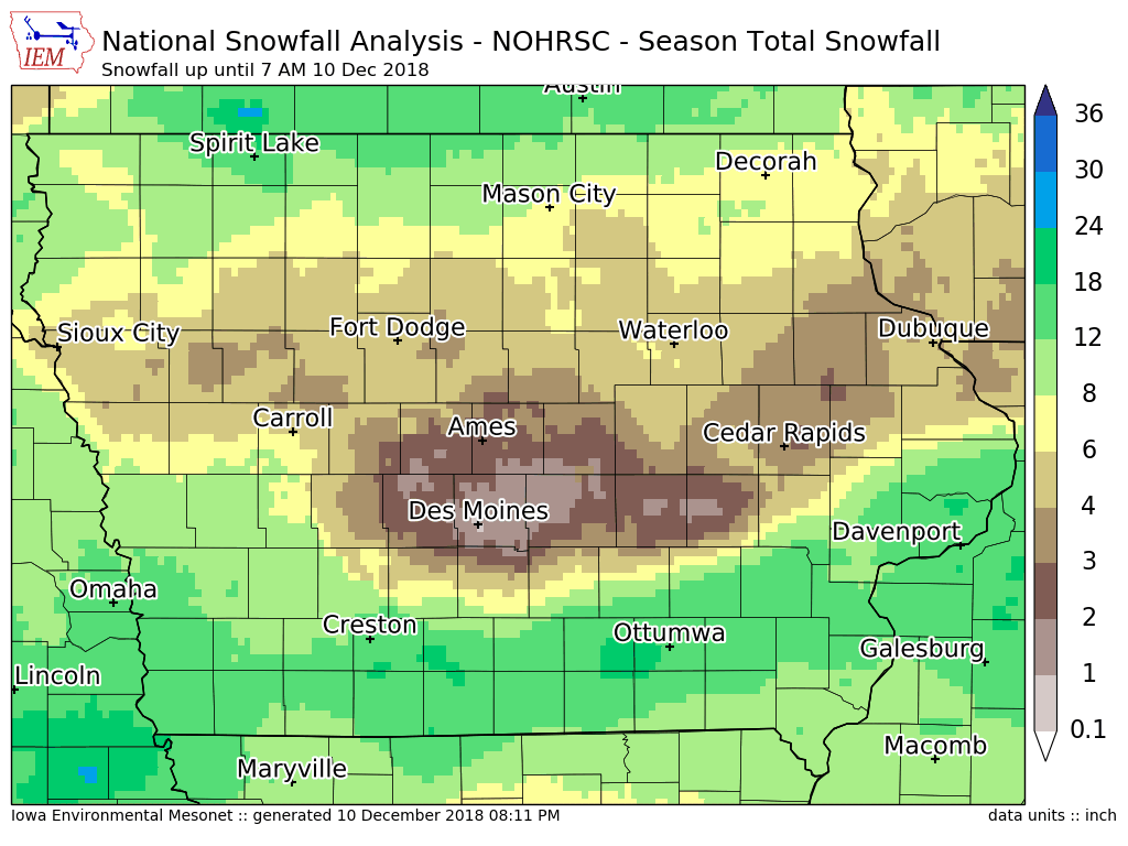
Snowfall Hole
11 Dec 2018 05:35 AMThe featured map presents total season snowfall as analyzed by NOAA NOHRSC. The analysis confirms what we in central Iowa already know, that is the snowfall hole over the center of the state exists. The big snowfall events have missed us to the north, east, and south. If you look closely, there is even one pixel analyzed at less than an inch total over Des Moines. Some precipitation is in the forecast, but nothing significant for accumulating snowfall.
Voting:
Good: 12
Bad: 0
Tags: winter1819

'18-'19 Winter Storm #6
03 Dec 2018 08:30 AMThe snow producing winter storms continue at a brisk pace with northwestern Iowa picking up the heaviest amounts from the weekend's storm system. The storm also brought significant rainfall to much of the state. The prolonged snowfall event happening over the weekend is making for a bit of a difficult snowfall analysis shown here, but another attempt will be made at generating a graphic later today once more data arrives. The forecast has this week mostly dry, so hopefully we can get a bit of a break from the snow storms.
Voting:
Good: 5
Bad: 1
Tags: winter1819

'18-'19 Winter Storm #5
26 Nov 2018 08:10 AMThe winter storms have been coming quickly this November and the most recent storm was one of the more significant storms for November on record. The snow combined with wind created blizzard conditions over southern Iowa on Sunday, which was very poor timing for folks traveling home after Thanksgiving break. The featured map attempts to depict the extreme cut off between areas that received a foot of snow and those that got none. This border is as tight as 5 miles in some locations.
Voting:
Good: 14
Bad: 0
Tags: winter1819

'18-'19 Winter Storm #4
19 Nov 2018 05:34 AMThe snow producing winter storm systems came in rapid succession this past weekend with the first round dropping upwards of four inches over mainly northeastern Iowa and the second round impacting southern Iowa with slightly higher totals. The featured map analysis of available NWS and CoCoRaHS reports is for the second storm. Some of the totals shown in far southeastern Iowa may been a combination of snow from the first storm. All of this snow will likely not survive for Thanksgiving as temperatures are expected to warm.
Voting:
Good: 10
Bad: 1
Tags: winter1819

'18-'19 Winter Storm #3
18 Nov 2018 11:22 AMThe featured map is of snowfall totals from the first snow producing event this weekend between Friday and Saturday morning. The heaviest totals were confined to northeastern Iowa with a few reports over four inches. This map is likely underdone over far southeastern Iowa as it will be difficult to make an analysis there with the snow falling after the morning reporting time and much more snow falling in the location overnight on Saturday. Irregardless, the snow was combined with very cold temperatures and record lows set on Sunday morning.
Voting:
Good: 3
Bad: 2
Tags: winter1819

'18-'19 Winter Storm #2
10 Nov 2018 11:03 AMWhile not much of a winter storm, the light snow was able to accumulate over some portions of the state and bring upwards of two inches to isolated locations. For the purposes of the IEM winter storm accounting, any events like these that get a few reports of at least two inches are counted in the season total. The big story with this event was the bitter cold that settled in afterwards leading to record low temperatures over some locations in the state. We'll have a few more cold days prior to a warm up later in the week.
Voting:
Good: 9
Bad: 0
Tags: winter1819

'18-'19 Winter Storm #1
15 Oct 2018 07:55 AMWell, here we are, the middle of October and already accumulating our first snowfall of the season. This event comes painfully early after a very snowy April making for one of the shortest periods between the last spring snowfall and first fall snowfall. The largest snowfall totals were isolated to far northwestern Iowa and near Omaha. This snow won't last long as soils are still rather warm and sunshine is expected today. Considering that our average high temperatures should be near 60 degrees, this current weather is not typical for mid October!
Voting:
Good: 12
Bad: 1
Tags: winter1819