Past IEM Features tagged: winter1718
The IEM generates per winter storm analyses of snowfall reports over Iowa and tags them by the winter season. Here are the tags used for the previous winter seasons that these maps are available for:
- Winter 2010-2011
- Winter 2011-2012
- Winter 2012-2013
- Winter 2013-2014
- Winter 2014-2015
- Winter 2015-2016
- Winter 2016-2017
- Winter 2017-2018
- Winter 2018-2019
- Winter 2019-2020
- Winter 2020-2021
- Winter 2021-2022
- Winter 2022-2023
- Winter 2023-2024

'17-'18 Winter Storm #28
19 Apr 2018 08:07 AMCould this be the last snow producing storm of the season? Let us hope so! The featured map analysis shows extreme northern Iowa receiving upwards of twelve inches of concrete snowfall. This snow fell quickly on Wednesday and melted quickly off of roadways thanks to mid-April solar angle. It was remarkable to see most of northern Iowa return to seasonable driving conditions by late afternoon after getting that much snowfall in the morning.
Voting:
Good: 8
Bad: 2
Tags: winter1718

'17-'18 Winter Storm #27
15 Apr 2018 08:16 PMEven though the calendar now says mid April, the winter season just will not quit. The brief warm up of last week now seems a distant memory with a major winter storm dumping tremendous amounts of snow over the Midwestern US. Far northwestern Iowa received 8 to 16 inches of snowfall and combined with cold and extremely strong winds, blizzard conditions prevailed for much of the weekend. Light snowfall does continue to fall this Sunday evening at the time of posting this map analysis, so it will likely need to be updated in the morning after more reports come in.
Voting:
Good: 14
Bad: 0
Tags: winter1718

'17-'18 Winter Storm #26
09 Apr 2018 07:53 AMCould this finally be winter's last significant snow storm for Iowa? I suspect that most folks are hoping that the answer is yes. The featured map depicts the highest totals over north central Iowa with amounts over eight inches reported in select areas. The other big story with this event was the very cold temperatures with locations flirting near all time April lows around this event. Typically when we see snowfall in April, there is a warm side of the storm with rain reported, but not so with this event as it almost all fell as snowfall. The forecast has very warm temperatures in store later this week, but pessimism is strong after the last few weeks of not-spring weather.
Voting:
Good: 9
Bad: 1
Abstain: 1
Tags: winter1718

'17-'18 Winter Storm #25
04 Apr 2018 08:04 AMThere has been no let up of winter even with our calendar now saying April. Heavy snowfall and bitter cold temperatures best describe Iowa's current weather. The featured analysis indicates the largest totals near the Minnesota border with no appreciable snowfall over southern Iowa. There is still more chances of snowfall in the forecast!
Voting:
Good: 22
Bad: 3
Abstain: 2
Tags: winter1718

'17-'18 Winter Storm #24
02 Apr 2018 07:56 AMApril Fool's Day for Iowa was no trick but actual cold and even snow for far southern Iowa. The featured snowfall analysis shows 1-3 inches clipping the far southern border of the state. Heavier amounts were found just south into Missouri. The rest of the state suffered along with very cold temperatures struggling to breach even above freezing levels. Suffice it to say that our average daily high temperatures for early April are at much warmer levels. An another snow producing storm arrives tonight with northern Iowa receiving the heaviest totals.
Voting:
Good: 5
Bad: 0
Abstain: 1
Tags: winter1718

'17-'18 Winter Storm #23
25 Mar 2018 12:23 PMOur most recent winter storm produced the largest totals of snowfall so far this season. The featured map displays an analysis of NWS Local Storm Reports, COOP, and CoCoRaHS observations. There was a sharp gradient of snowfall on the northern side with far northeastern Iowa indicated missing out completely. Totals over a foot were reported from Mason City south and east to Davenport. This snowfall was very heavy with snow to liquid ratios well below ten. These late season snowfalls do not tend to stick around long and any sunshine is able to make quick work of snow on concrete surfaces.
Voting:
Good: 17
Bad: 1
Abstain: 1
Tags: winter1718

Remarkable Snowfall Gradient
20 Mar 2018 05:32 AMThis past weekend's storm left a remarkable gradient of snowfall over central Iowa. The featured map combines MRMS RADAR based precipitation estimates (these would be liquid totals) and NWS received Local Storm Reports (snow fall in inches). The gradient displayed goes from under a half inch over southern Des Moines to 8 inches at Huxley and then an inch or two for Ames. The RADAR estimates nicely coincide with these reports with the bulls-eye over Huxley. All of this snowfall is already gone as temperatures warmed very nicely on Monday.
Voting:
Good: 15
Bad: 1
Abstain: 1
Tags: winter1718

'17-'18 Winter Storm #22
18 Mar 2018 12:40 PMOur most recent winter storm dumped a remarkably tight gradient of heavy snowfall between Des Moines and Ames. The featured map is an attempted analysis of available reports, but is likely not fully representing the very sharp gradient that occurred. This tight gradient was thanks to a small scale snow producing band that pivoted over the same area for a number of hours on Saturday. The snowfall was extremely wet as well with snow to liquid water ratios below 10. Much of this snow melted later on Saturday. Will have more features on this event later this week!
Voting:
Good: 18
Bad: 1
Abstain: 1
Tags: winter1718

'17-'18 Winter Storm #21
11 Mar 2018 09:49 PMThe weekend before most schools enjoy spring break brought a bit of snow to the state. The featured analysis depicts generally light amounts of snow with a few locations picking up more substantial totals. Much of this snow is expected to melt on Monday with highs back above freezing.
Voting:
Good: 9
Bad: 1
Abstain: 1
Tags: winter1718

'17-'18 Winter Storm #20
06 Mar 2018 08:25 AMThe featured map displays snowfall reports so far from our current winter storm. Heavy rainfall was again observed over southeastern Iowa. The highest snowfall totals were over far northeastern Iowa with amounts over six inches. The wet snow, strong winds, and below freezing temperatures have made for some significant travel impacts over Iowa on Monday and Tuesday. Light snow continues to fall as the large storm system swirls over the state this morning. This map will be updated later today with any additional snowfall reported during today.
Voting:
Good: 10
Bad: 1
Abstain: 1
Tags: winter1718

'17-'18 Winter Storm #19
25 Feb 2018 08:30 PMOur most recent winter storm visited the state on Saturday and brought some rain, freezing rain, and snow. The featured map displays available snowfall reports from the event and amounts were generally an inch or two over far northern Iowa. A dusting of snow was reported over locations further to the south. Warmer temperatures arrived on Sunday and are efforting some long awaited snow removal over northern portions of the state.
Voting:
Good: 9
Bad: 2
Abstain: 1
Tags: winter1718

'17-'18 Winter Storm #18
23 Feb 2018 08:20 AMThe winter systems have continued at a fast pace this February and unlike January, these systems have packed a lot more moisture. This moisture should help the drought situation building in the state, but with frozen soils, this water tends to mostly run away. The featured analysis only depicts the snowfall reports, but other locations received some freezing rain and rain. Our next storm system arrives already on tomorrow, Saturday.
Voting:
Good: 8
Bad: 1
Abstain: 2
Tags: winter1718

'17-'18 Winter Storm #17
21 Feb 2018 05:32 AMOur most recent bout with winter brought a mixed bag of precipitation to the state over the past two days. The featured map presents NWS Local Storm Reports showing snow over northwestern Iowa, heavy rainfall over southeastern Iowa, and freezing rain in-between. Freezing rain amounts where generally a tenth of an inch or so. The next wintery mix arrives in a day or so.
Voting:
Good: 4
Bad: 0
Tags: winter1718

'17-'18 Winter Storm #16
18 Feb 2018 01:17 PMA quick moving system brought a brief downpour of snowfall on Saturday which only amounted to an inch or two over the state, but created for some travel impacts due to the intense snowfall rate. Most of this snowfall melted later on Saturday as temperatures warmed nicely to finish the day. Our next storm system will be here tonight.
Voting:
Good: 9
Bad: 1
Abstain: 1
Tags: winter1718

'17-'18 Winter Storm #15
11 Feb 2018 01:55 PMThe snow producing storms are coming faster than I can post IEM Daily Features with an analysis of totals! This most recent round dumped generally light amounts over much of the state with the far southeastern corner receiving the heaviest amounts over three inches. For those of you sick of the snow, it appears a break is on the way with even some above freezing temperatures this week. Having clear skies is also a big help as the ever increasing sun angle is able to heat concrete surfaces to help melt away the packed snow and ice.
Voting:
Good: 13
Bad: 1
Abstain: 1
Tags: winter1718

'17-'18 Winter Storm #14
10 Feb 2018 07:31 PMThe snow producing winter storms are coming fast and furious with the most recent storm dumping its heaviest totals over southern Iowa. The featured map displays the combination of NWS COOP, Local Storm Reports, and CoCoRaHS reports for the event. Areas north of Ottumwa reported the heaviest totals over six inches. The next round of snowfall is already here this Saturday evening with the heaviest totals expected over southern Iowa again.
Voting:
Good: 5
Bad: 0
Tags: winter1718

'17-'18 Winter Storm #13
09 Feb 2018 09:05 AMThe snow producing winter storms continue at a frantic pace. This most recent storm produced a very sharp southern gradient to the snowfall totals with a stripe near highway US-20 between six and twelve inches. More snowfall is expected later today, but totals are expected to be an inch or snow and focused over southern Iowa.
Voting:
Good: 12
Bad: 1
Tags: winter1718
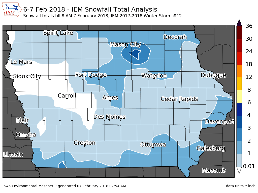
'17-'18 Winter Storm #12
07 Feb 2018 07:58 AMThe snow producing storms have been coming in quick succession lately. Light snow fell over much of the state on Tuesday evening into Wednesday with the featured map depicting a smoothed analysis of available reports from the NWS. Most reports were generally an inch or less. Plenty more chances of snow are in the immediate term forecast and sub-freezing temperatures, so if you like snow and falling snow, this is a good time of year for you!
Voting:
Good: 8
Bad: 1
Abstain: 1
Tags: winter1718

'17-'18 Winter Storm #11
06 Feb 2018 08:19 AMFinally, a significant snowfall for central Iowa! For Des Moines, the longest stretch of days without receiving three inches of snow ended on Monday with five to six inches reported over the metro area. The featured map displays available snowfall reports and shows a good portion of the state picking up four or more inches. This snowfall caused major traffic issues as snowfall rates and daytime traffic conspired for many accidents. More snowfall is expected later today, but amounts will be much less than this most recent storm.
Voting:
Good: 14
Bad: 0
Tags: winter1718

'17-'18 Winter Storm #10
04 Feb 2018 09:42 PMIt may be a bit of a stretch to lump this past weekend's snow producing systems into one storm, but we shall! The featured map displays totals over Saturday and Sunday as portions of far northeastern Iowa reported upwards of four inches. Locations to the south and west picked up much more rain than snowfall from this event. Our next snowfall producing system arrives on Monday, just in time for you to call in sick from work after the Super Bowl!
Voting:
Good: 8
Bad: 1
Abstain: 1
Tags: winter1718

'17-'18 Winter Storm #9
30 Jan 2018 05:33 AMWhile not much of a winter storm, the most recent snow producing system did meet the arbitrary IEM Daily Feature accounting of two plus inches somewhere in the state. This system dumped an inch or two over far northern Iowa Saturday evening and into Sunday morning. For the rest of the state, we just got the cold air behind the front with highs on Sunday and Monday below freezing for much of the state.
Voting:
Good: 9
Bad: 2
Abstain: 2
Tags: winter1718

'17-'18 Winter Storm #8
23 Jan 2018 08:23 AMThe strongest winter storm of the season for Iowa dumped major amounts of snow over northwestern Iowa and along with very strong winds, created for blizzard conditions for much of Monday over the area. The featured snowfall reports analysis shows upwards of a foot of new snow over far northwestern Iowa with amounts quickly dropping off to the south and east of this area. This system also brought heavy rainfall to the state with some locations, like Waterloo, nearly receiving two inches of rain!
Voting:
Good: 9
Bad: 0
Tags: winter1718

'17-'18 Winter Storm #7
15 Jan 2018 08:09 AMOur continuing series of fluffy and light producing snow storms continued Sunday evening with most of the state picking up an inch or more. Amounts approaching six inches were reported over far Northeastern Iowa. Strong winds after the snow produced blowing snow and near whiteout conditions over northern Iowa. We are again left with very cold temperatures and dangerous wind chills after the passing snow storm. The official snowfall report for Des Moines was again below three inches, continuing the record stretch for the site to nearly 750 days.
Voting:
Good: 9
Bad: 1
Abstain: 1
Tags: winter1718

'17-'18 Winter Storm #6
12 Jan 2018 07:54 AMOur brief respite from cold winter weather ended on Thursday as a winter storm brought rain, freezing rain, sleet and snow to the state. The amount of snow produced was under what was anticipated, but the cold temperatures and dangerous wind chills did materialize for today. The featured map presents a smooth analysis of reports received. There were fewer than normal amount of reports made for this event as generally low totals and cold temperatures likely were discouraging for snowfall reports to be made. More snow and cold is in the forecast as winter rolls on for Iowa.
Voting:
Good: 9
Bad: 2
Abstain: 1
Tags: winter1718

'17-'18 Winter Storm #5
31 Dec 2017 10:24 PMThe snow producing storm systems have been coming quickly recently. The most recent system dumped an inch or two of fluffy snow over the state with the highest totals confined to west-central Iowa. As with some of the previous snowfalls, the usage of the term "winter storm" is probably generous for how "strong" the snow producing system is. Putting that aside, the snow dumped by these systems do have to be dealt with and do create travel headaches.
Tags: winter1718

'17-'18 Winter Storm #4
30 Dec 2017 09:20 AMThe heaviest snow storm of the season dumped four to eight inches over a stripe of Iowa yesterday. Totals rapidly dropped off to the south of this stripe. Some freezing drizzle was also observed with this storm. Extremely cold air has now invaded the state and will stick around into the new year.
Voting:
Good: 7
Bad: 0
Tags: winter1718

'17-'18 Winter Storm #3
29 Dec 2017 07:18 AMOur latest snowfall producing storm brought just an inch or two to much of the state. The event came in two waves on Wednesday and Thursday. Given the holiday season, light totals and accumulation over two reporting days, reports were a bit sparse for this map. Regardless the highest totals stretched from Sioux City to southeast to Keokuk. More snow is on the way for today with more significant totals expected.
Voting:
Good: 9
Bad: 0
Tags: winter1718

'17-'18 Winter Storm #2
25 Dec 2017 06:30 AMA light and fluffy snowfall arrived just in time to make for a white Christmas for much of southern Iowa. The featured map displays an IEM analysis of available snowfall reports from the NWS. Two to four inches were common over far southern Iowa with values generally an inch or less over northern Iowa. Very cold air has now settled into the state making for a very Christmas Day. The very cold air looks to stick around until the end of this year.
Voting:
Good: 5
Bad: 0
Tags: winter1718

'17-'18 Winter Storm #1
12 Dec 2017 07:55 AMThe IEM generates snowfall analysis maps based on NWS COOP observations, Local Storm Reports, and CoCoRaHS reports. The arbitrary requirement for classifying these events as storms is for somewhere in Iowa to receive 2+ inches of snow or to have significant impacts from ice and/or blowing snow. So far NE Iowa has some isolated totals of two inches, so we have our first "winter storm" of the season. There have been other light snow producers in the state this season, but only have seen an inch or less reported. Look for more maps like these as the season progresses and the "Winter Storms of 2017- 2018" link on the homepage will bring you to a page showing all these maps.
Voting:
Good: 6
Bad: 1
Tags: winter1718