Past IEM Features tagged: winter1314
The IEM generates per winter storm analyses of snowfall reports over Iowa and tags them by the winter season. Here are the tags used for the previous winter seasons that these maps are available for:
- Winter 2010-2011
- Winter 2011-2012
- Winter 2012-2013
- Winter 2013-2014
- Winter 2014-2015
- Winter 2015-2016
- Winter 2016-2017
- Winter 2017-2018
- Winter 2018-2019
- Winter 2019-2020
- Winter 2020-2021
- Winter 2021-2022
- Winter 2022-2023
- Winter 2023-2024

'13-'14 Winter Storm #29
14 Apr 2014 08:15 AMThe hope that Iowa was done with snow producing storms was dashed Sunday evening as yet another system was able to dump snow on Iowa. The storm system also brought a significant amount of rain with it as well. Snowfall totals were generally less than three inches and will melt quickly with any amount of sunshine. The cool weather looks to stick around this week with further chances of snow later in the week.
Voting:
Good: 15
Bad: 4
Abstain: 4
Tags: winter1314

'13-'14 Winter Storm #28
04 Apr 2014 08:30 AMThe most recent snow producing storm system is exiting the state this Friday morning with some isolated locations picking up a lot of snowfall. A narrow strip is shown in the featured map analysis over six inches. Having snowfall events like this in early April are common and about what we would expect when large storm systems crank up over the plains. The good news is that any sunshine will make quick work of this snow and the forecast has hope of much warmer temperatures.
Voting:
Good: 38
Bad: 10
Abstain: 5
Tags: winter1314

Accumulating the Snowfall
21 Mar 2014 04:43 AMThe featured chart presents the season accumulation of daily snowfall reports for Dubuque, Minneapolis, and Chicago (O'Hare Airport). All three sites are well above their average snowfall with Chicago more than doubling it. It is interesting to compare the season to date totals for the three sites at various points this winter. Chicago really started to pile up the snowfall after the start of the new year. Chances of more snow are in the forecast for next week, so we can add to these totals yet!
Voting:
Good: 40
Bad: 11
Abstain: 10
Tags: winter1314
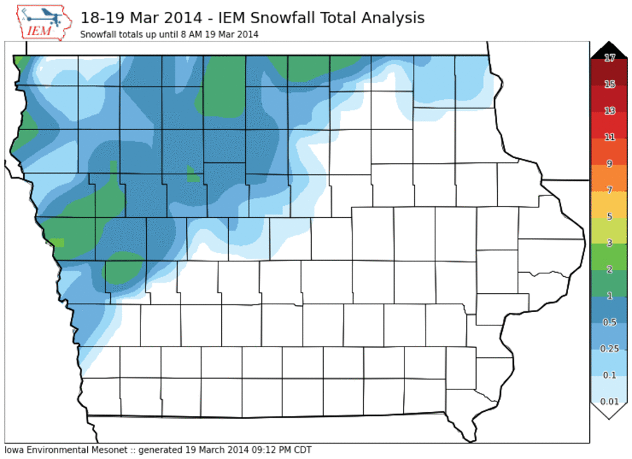
'13-'14 Winter Storm #27
20 Mar 2014 05:46 AMWe are padding the winter season stats at this point with the most recent round of snow only amounting to an inch or two over northern Iowa. Winds were strong with this storm system producing blowing snow and some difficult travel conditions. Today is the vernal equinox (start of spring), but cold weather and a few chances of snow are in the forecast after a few days in the 50s.
Voting:
Good: 17
Bad: 5
Abstain: 5
Tags: winter1314

'13-'14 Winter Storm #26
16 Mar 2014 04:55 PMOur recent stretch of warm weather and melting snow has been replaced by cold temperatures and a new snowfall. The highest totals from this latest bout with winter were over southeastern Iowa with two inches or less over much of the rest of the state. Sunshine on Sunday was able to make quick work of much of this snowfall and warmer temperatures are in the forecast for this week.
Voting:
Good: 15
Bad: 5
Abstain: 4
Tags: winter1314

'13-'14 Winter Storm #25
05 Mar 2014 11:26 AMFar northeastern Iowa picked up a considerable amount of snowfall last night into this morning with totals well over six inches in some locations. Amounts quickly dropped off to the south of the highest totals. The good news is that warmer temperatures are on the way and the melting process can proceed!
Voting:
Good: 14
Bad: 3
Abstain: 3
Tags: winter1314

'13-'14 Winter Storm #24
02 Mar 2014 10:59 AMFalling snow has finally moved south of Iowa this Sunday morning after lingering across the state since Friday. The featured map is an attempt at an analysis of reported snowfall for the entire event. Snow totals were highly variable with some locations getting over six inches, while others got less than an inch. The snow fell at very cold temperatures, so the wind was able to easily blow it around due to the lower water content. Even with the March sunshine today, temperatures will not be pleasant with afternoon highs struggling to reach 0! Record smashing cold is expected tonight with some locations flirting with all-time record cold lows for March.
Voting:
Good: 45
Bad: 12
Abstain: 10
Tags: winter1314

Relative Time below 0
28 Feb 2014 05:36 AMYesterday's feature presented the number of hours below zero Fahrenheit so far this winter season. The icebox in northern Minnesota had much larger totals than anywhere else in the Midwest, but they are also typically cold during the winter season! Today's image attempts to normalize the presented totals by comparing this year's amount of time below zero with the past 41 years worth of data. This analysis places Ohio and SE Michigan with the highest ratios. A ratio of 3 would imply that the location has seen three times as long a duration below zero than on average. So while Minnesota has seen roughly double the sub-zero time (which is a much longer duration in absolute terms than in Ohio), it is the eastern part of the Midwest that has been the most relative difference this winter season.
Voting:
Good: 49
Bad: 16
Abstain: 8
Tags: subzero winter1314

'13-'14 Winter Storm #23
25 Feb 2014 01:42 PMAfter featuring the west to east gradient of snowfall so far this winter season with western Iowa totals much less than eastern Iowa, the heaviest totals were over western Iowa for this most recent storm. The totals were not that impressive though with most locations less than three inches. The bad news is very cold air is once again here for the rest of this week as winter rolls on.
Voting:
Good: 14
Bad: 5
Abstain: 6
Tags: winter1314

West-East Snow Gradient
24 Feb 2014 05:39 AMThe featured map presents NWS reported snowfall totals for this cold season. A remarkable gradient exists over Iowa with extreme eastern Iowa over 50 inches and extreme western Iowa around 10-15. A similar gradients exists over Minnesota as snow producing storms have favored the eastern portion of the upper MidWest. Some snowfall is expected today with the largest totals over western Iowa, but amounts will only be a couple of inches.
Voting:
Good: 42
Bad: 7
Abstain: 4
Tags: winter1314

'13-'14 Winter Storm #22
21 Feb 2014 08:11 AMMost of our winter storm systems this season have been on the weak side with limited moisture to work with. Thursday's storm was much more powerful and had plenty of moisture to work with. Besides the significant snowfall totals dumped over northcentral Iowa, this system also brought rain and measurable accumulations of sleet / small hail. Winds increased Thursday evening creating blizzard conditions over northern Iowa, but impacts were a bit lower than feared due to sightly above freezing temperatures that lowered snowfall totals (due to very high water content), which also helped to decrease the ability of the snow to blow around. The situation over northcentral Iowa is a mess this morning.
Voting:
Good: 49
Bad: 7
Abstain: 4
Tags: winter1314

'13-'14 Winter Storm #21
18 Feb 2014 08:19 AMIowa experienced yet another snow producing storm on Monday with totals upwards of six inches over portions of eastern Iowa. The snow came quickly with rates approaching three inches per hour and thundersnow was reported as well. The good news is that temperatures are quickly warmed and will eat away at the snow cover of the state. The bad news it that a blizzard watch is in effect for Thursday as the next winter storm system looks to be a very powerful.
Voting:
Good: 27
Bad: 2
Abstain: 4
Tags: winter1314

'13-'14 Winter Storm #20
16 Feb 2014 09:10 PMAnd yet another snow producing winter storm this season quickly dumped a couple of inches or so on Iowa this past Saturday. The featured analysis combines NWS Cooperative, NWS Local Storm, and CoCoRaHS reports. Totals approached four inches and were generally in the 1-3 inch range. Monday is another day, so that means another snow producing storm! The heaviest totals will be over northeastern Iowa this time. The good news is that temperatures will be warmer this week with highs above freezing!
Voting:
Good: 35
Bad: 8
Abstain: 5
Tags: winter1314

'13-'14 Winter Storm #19
15 Feb 2014 04:10 PMThe snow producing winter storms are coming faster than I can post daily features on their snowfall totals! The featured map is an analysis of reports from the snowfall on Friday. Some of the snow from Saturday's storm may have been included in this analysis. Totals were generally less than four inches, but higher amounts were observed over southeastern Iowa. There was some wind with this snow as well, so driving conditions were once again difficult.
Voting:
Good: 36
Bad: 3
Abstain: 2
Tags: winter1314

'13-'14 Winter Storm #18
10 Feb 2014 05:41 AMAnd yet another snow producing winter storm brought 1-3 inches over a good portion of Iowa. This event did not include significant winds, so impacts were on the minimal side. The largest totals were over far eastern Iowa. Temperatures are once again very cold this Monday morning, but there is hope in the forecast as temperatures above freezing are expected later this week!
Voting:
Good: 32
Bad: 8
Abstain: 3
Tags: winter1314

'13-'14 Winter Storm #17
05 Feb 2014 09:10 AMAnd yet another winter storm system brings snowfall to the state! Unlike many of the previous storm systems, this one was a more traditional winter storm that traversed from west to east passing just to our south. These type of systems have more moisture to work with than clipper type systems and snowfall totals, accordingly, were higher than we have recently seen. Three to Five inches were common over much of southern Iowa with higher totals exceeding seven inches. Bitterly cold air is once again back in Iowa with lows tonight well below zero.
Voting:
Good: 42
Bad: 12
Abstain: 11
Tags: winter1314

'13-'14 Winter Storm #16
02 Feb 2014 09:34 PMThe featured map presents an analysis of snowfall totals from our most recent snow producing winter storm system. Technically the snowfall for this analysis came in two waves on Friday and then again on Saturday. Much of the state got at least an inch or two with the highest amounts over far southeastern Iowa. Our next snow storm arrives late Monday with the heaviest totals expected over southern Iowa. Very cold temperatures look to be in the forecast this week as well. Winter continues to roll on!
Voting:
Good: 22
Bad: 6
Abstain: 5
Tags: winter1314

'13-'14 Winter Storm #15
31 Jan 2014 08:01 AMOur most recent fast moving winter storm brought a few inches of snow over northern Iowa, but also produced gusty winds which lead to some drifting again. Our next snow producing storm system is already here this morning and is expected to bring higher snowfall totals than this previous system. While we have been seeing numerous snow producing storm systems, the actual snowfall totals have been rather light. Today's storm will approach us from the southwest, which allows it to potentially work with more moisture and thus produce more snowfall.
Voting:
Good: 52
Bad: 15
Abstain: 13
Tags: winter1314

'13-'14 Winter Storm #14
26 Jan 2014 02:14 PMAnd yet another fast moving winter storm system dumped a bit of snow over Iowa on Saturday with the highest totals approaching four inches. These totals are not associated with the ongoing blizzard impacting Iowa on Sunday, but the deposited snow is being blown around by the intense winds associated with Sunday's storm. The winter storms continue in rapid succession with the current orientation of the upper level atmospheric flow stuck in a pattern that brings us quick shots of snow.
Voting:
Good: 21
Bad: 5
Abstain: 1
Tags: winter1314

'13-'14 Winter Storm #13
22 Jan 2014 05:40 AMAnd yet another storm system producing snowfall is in the books. This round only brought a dusting to most of Iowa with amounts of 1-3 inches in some locations. This snow was thanks to yet another fast moving clipper system that have been common this winter season. Warmer temperatures have crept back into the state overnight, but will be quickly ushered away again with cold air arriving after the next round of light snowfall. This pattern looks to continue into February.
Voting:
Good: 23
Bad: 7
Abstain: 6
Tags: winter1314
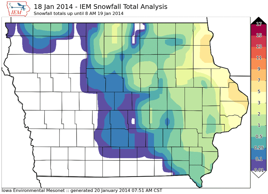
'13-'14 Winter Storm #12
20 Jan 2014 07:56 AMThis past Saturday saw yet another "clipper" system bring a quick shot of rain, sleet, and snowfall. Snowfall totals over extreme northeastern Iowa reached six inches. The large scale weather pattern that has produced the historic drought in California is oriented to continue to usher down these clipper systems that produce snow and quickly move out. The next such system arrives tonight with very cold air behind it with highs tomorrow in the single digits.
Voting:
Good: 16
Bad: 4
Abstain: 9
Tags: winter1314

'13-'14 Winter Storm #11
17 Jan 2014 02:58 PMA small amount of snowfall made for a tremendous impact over central Iowa on Thursday. Snowfall totals were generally less than three inches, but combined with rush hour traffic, strong winds, and pavement temperatures that were initially warm enough to melt the snow and then quickly freeze it, created for dangerous driving conditions. The city of Des Moines was especially hard hit by this storm with blizzard conditions existing during peak traffic hours Thursday evening. The good news is that warmer temperatures and sunshine will make quick work of this snow and ice over the weekend.
Voting:
Good: 18
Bad: 8
Abstain: 6
Tags: winter1314

'13-'14 Winter Storm #10
02 Jan 2014 07:59 AMThe new year started off with yet another snow producing storm. The largest totals were over southern Iowa this time with amounts generally under three to four inches. The featured map presents an analysis of snowfall reports and attempts to not include reports from the previous snow storm on the 31st of December. Very cold weather is in the forecast with early next week looking to set records for cold temperatures.
Voting:
Good: 29
Bad: 1
Abstain: 3
Tags: winter1314

'13-'14 Winter Storm #9
01 Jan 2014 07:48 AMThe snow producing storm systems have been coming in rapid succession. The most recent system dumped upwards of five inches over northeastern Iowa. More snow is falling this morning with the heaviest totals expected over southeastern Iowa. Even colder weather is expected behind this system and another shot of very cold air next week. Those of you that like winter are probably happy right now!
Voting:
Good: 29
Bad: 6
Abstain: 4
Tags: winter1314

'13-'14 Winter Storm #8
31 Dec 2013 07:40 AMOur most recent bout with a snow producing storm system dumped just a few inches of fluffy snow over Iowa. The highest totals were south of Waterloo. This snow caused a number of traffic headaches as very cold temperatures made keeping roads clear difficult. Another snow producing storm arrives today and is expected to dump a bit more snow than this storm over northern Iowa.
Voting:
Good: 27
Bad: 3
Abstain: 4
Tags: winter1314

'13-'14 Winter Storm #7
23 Dec 2013 05:37 AMThe most recent snow storm brought the most significant totals of the season so far with the highest amounts over southern Iowa around nine inches. The freezing rain event of late last week did not help matters any as side streets remain very slick from the ice that remains and now the new snowfall. A white Christmas looks to be assured for much of the state now as temperatures will plummet Monday evening with the coldest air of the season arriving.
Voting:
Good: 51
Bad: 2
Abstain: 3
Tags: winter1314

'13-'14 Winter Storm #6
15 Dec 2013 11:48 AMAnd yet another winter storm impacted Iowa late last week with the heaviest totals over extreme southeastern Iowa. There was also much lighter snowfall totals over northwestern Iowa. Some light snow is falling in Iowa this Sunday with totals not expected to amount to much. The good news is that some warmer weather is expected this week before we plunge back into very cold temperatures next weekend.
Voting:
Good: 72
Bad: 6
Abstain: 5
Tags: winter1314

'13-'14 Winter Storm #5
12 Dec 2013 05:36 AMThe snow producing winter storms have been coming at a rapid rate with the most recent round dumping upwards of five inches. This storm was accompanied by gusty winds and bitter cold temperatures. The good news is that temperatures are already on the rise this morning thanks to southerly winds and will be in the 20s this afternoon! The bad news is that we look to remain below freezing for the foreseeable future.
Voting:
Good: 26
Bad: 4
Abstain: 4
Tags: winter1314

'13-'14 Winter Storm #4
09 Dec 2013 08:17 AMOur most recent bout with falling snow is over this Monday morning with the featured map showing an analysis of snowfall reports. The highest totals just over five inches were just to the west of Des Moines. Totals of two to four inches were common over much of the rest of the state. Is there a chance that this snow could stick around until Christmas? The near term forecast continues the very cold weather.
Voting:
Good: 30
Bad: 6
Abstain: 3
Tags: winter1314

'13-'14 Winter Storm #3
26 Nov 2013 08:23 AMSnowfall totals on Monday reached 5 inches just east of Waterloo as yet another winter storm impacted Iowa this November. The featured analysis combines NWS storm reports with CoCoRaHS and COOP reports. This snow looks to stick around for Thanksgiving as temperatures won't climb back above freezing until this coming weekend. The good news is that travel will not be a problem in Iowa, unlike the east coast which is dealing with a major winter storm.
Voting:
Good: 29
Bad: 1
Tags: winter1314

'13-'14 Winter Storm #2
25 Nov 2013 05:43 AMThe featured map presents an IEM analysis of reported snowfall totals from the winter storm late last week. The largest report was only two inches, but this storm brought freezing rain and sleet, making for difficult travel conditions. Very cold air also filtered in behind this storm system making for a cold weekend. Winter looks to have firm control on our forecast with below freezing temperatures expected for much of this week and a fresh dusting of snow this Monday morning.
Voting:
Good: 25
Bad: 4
Abstain: 4
Tags: winter1314

'13-'14 Winter Storm #1
06 Nov 2013 07:49 AMOur first winter storm with significant snowfall for the season is in the books. The featured map presents an analysis of reports showing the heaviest totals approaching 4-5 inches in extreme northwestern Iowa with amounts quickly dropping off to the south and east. Much of the state picked up needed rainfall with half inch and greater totals common. The IEM generates featured analysis maps like these after snowfall events where totals were generally greater than an inch or two. The winter season sees other snowfall events that produce lighter amounts and are not included in this series for the season.
Voting:
Good: 23
Bad: 7
Abstain: 2
Tags: winter1314