Past IEM Features tagged: winter1213
The IEM generates per winter storm analyses of snowfall reports over Iowa and tags them by the winter season. Here are the tags used for the previous winter seasons that these maps are available for:
- Winter 2010-2011
- Winter 2011-2012
- Winter 2012-2013
- Winter 2013-2014
- Winter 2014-2015
- Winter 2015-2016
- Winter 2016-2017
- Winter 2017-2018
- Winter 2018-2019
- Winter 2019-2020
- Winter 2020-2021
- Winter 2021-2022
- Winter 2022-2023
- Winter 2023-2024

'12-'13 Winter Storm #17
03 May 2013 08:28 AMNeedless to say, we are witnessing history and rewriting the snowfall record books for a storm in May! The featured map is an attempted analysis of the snow that has fallen so far over the past three days. The difficult part is that ground and pavement temperatures are warm, so the snow is melting as it falls. The iterative method of measuring snowfall every hour or so will also tend to inflate the totals as compaction is an important part of snowfall measurement. Regardless, a lot of moisture has fallen in the form of rain, sleet, and snow. This will be an event to remember for a long time! Enjoy witnessing history!
Voting:
Good: 147
Bad: 15
Tags: epic winter1213

'12-'13 Winter Storm #16
24 Apr 2013 05:40 AMThe remarkable April weather continued on Tuesday with our most recent storm system bringing the heaviest snowfall to northwestern Iowa and even producing a brief dusting over parts of southern Iowa. Is this finally the last storm of the season that brings along snow for Iowa? The forecast does hold some hope that it is. These late April snow storms are somewhat rare for Iowa, but do occur roughly once every eight years or so.
Voting:
Good: 49
Bad: 7
Tags: winter1213

'12-'13 Winter Storm #15
20 Apr 2013 08:06 AMThe snow storms in April for Iowa continued this week with our most recent bout of winter bringing over 6 inches of snow over extreme northwestern Iowa. This storm system also brought one of the heaviest widespread rainfalls in Iowa history for the rest of the state. Is this finally our last snowfall or could more be on the way? Unfortunately, more cold weather and snow looks possible next week!
Voting:
Good: 107
Bad: 13
Tags: winter1213

'12-'13 Winter Storm #14
12 Apr 2013 05:39 AMWhile we are in the second week of April and Spring started a number of weeks ago, our actual weather has been a different story. Northwest Iowa picked up the heaviest snowfall totals in the state from our recent storm. Totals were much higher to our north and west along with significant amounts of freezing rain causing major problems. Is this our last snow maker of the season? Some numerical models bring us more snow next week!
Voting:
Good: 56
Bad: 9
Tags: winter1213

'12-'13 Winter Storm #13
25 Mar 2013 08:07 AMOur latest bout with winter dumped the heaviest snowfall totals in Iowa over the southeastern portion of the state. Iowa missed out on the foot plus snowfall accumulations near Saint Louis. The snow is causing travel headaches this Monday morning as temperatures are cold enough for roadways to freeze. It will not take long this morning for roads to start clearing up as even though there are clouds, energy from the sun is still able to reach the pavement surface and warm it above freezing.
Voting:
Good: 35
Bad: 9
Tags: winter1213

'12-'13 Winter Storm #12
19 Mar 2013 05:43 AMThe number of winter storms have come at a frantic pace recently with our latest bout of winter only dropping a few inches of snow, but also produced a lot of wind to blow that snow around. The heaviest totals were in the Dubuque area around three inches. The next big winter storm looks to mostly miss us to the south! The cold air is going to stick around in the interim.
Voting:
Good: 37
Bad: 2
Tags: winter1213

'12-'13 Winter Storm #11
11 Mar 2013 07:37 AMOur most recent winter storm system is winding down this morning after dumping around a foot of snow over northwestern Iowa. The weekend storm systems also brought much needed rainfall to the state with rainfall totals near an inch or more in many locations in the state. This moisture is very welcome and should help the drought situation in the state. This image will be regenerated later today after more observations come in.
Voting:
Good: 29
Bad: 5
Tags: winter1213

Two to Four Feet
08 Mar 2013 05:27 AMThe featured map presents reported snowfall totals for the winter season to date from the NWS. Values in Iowa range from around two feet in western Iowa to four feet for Dubuque. The pattern is not that simple tho as locations like Mason City and Davenport have missed out on events in their areas. Will this be it for snowfall this year? A series of storm systems will affect the area this weekend with rain changing over to snow on Sunday. It does look to be a mostly rain event.
Voting:
Good: 76
Bad: 6
Tags: winter1213

'12-'13 Winter Storm #10
06 Mar 2013 09:02 AMThe second of our back to back snow storms dumped much more snow than the first. It also brought strong winds which caused blowing snow that impacted travel. Western Iowa missed out again on the heaviest totals. Our upcoming weather pattern looks to feel closer to spring than winter with the next storm system arriving this weekend and looking to produce mostly rain.
Voting:
Good: 40
Bad: 7
Tags: winter1213

'12-'13 Winter Storm #9
05 Mar 2013 05:39 AMThe first of back to back winter storms dumped just a few inches over parts of Eastern Iowa on Monday. The second storm system is here this morning with the heaviest totals again over eastern Iowa. This system will truck it east and is expected to cause trouble in the Washington DC area. Western Iowa has missed out again and they certainly have the greatest need for moisture. After this storm system, warmer weather will be here with snow melting temperatures near 40.
Voting:
Good: 38
Bad: 5
Tags: winter1213

'12-'13 Winter Storm #8
27 Feb 2013 07:30 AMThe snow is still falling this Wednesday morning and the totals are approaching a foot in some locations in the state. A band of moderate intensity snow setup Tuesday much further north and west than expected resulting in the swath of higher totals you see on the featured map between Des Moines and Waterloo. This map will be updated later today as more reports come in and the analysis is improved.
Voting:
Good: 44
Bad: 11
Tags: winter1213

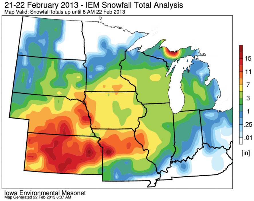
'12-'13 Winter Storm #7
22 Feb 2013 08:49 AMThe long awaited snowstorm on Thursday is winding down this morning after covering most of the state with around six inches. The heaviest totals were in western Iowa with up to ten inches reported. Even heavier amounts were over Kansas and Nebraska with locations just southwest of Iowa picking up around a foot.
Voting:
Good: 75
Bad: 21
Tags: winter1213

'12-'13 Winter Storm #5
03 Feb 2013 03:35 PMLast Sunday, much of the state picked up freezing rain with the heaviest accumulations shown on the featured map over Northern Iowa. A majority of the snowfall produced with this storm was north of the state, but it was a significant winter storm for Iowa and thus the inclusion in the running series on these events. Sorry about including the analysis for storm number six before this one! A number of smaller snow storms have been impacting the state in the past week as well. If reports are generally less than 3 inches, they are not counted in this analysis.
Voting:
Good: 8
Bad: 0
Tags: winter1213

'12-'13 Winter Storm #6
31 Jan 2013 08:33 AMThe warmer weather earlier this week is now a distant memory and much of the state is now covered with fresh snowfall. The featured analysis of snowfall reports from the event show the highest totals near Waterloo around 8-10 inches. Northwest Iowa completely missed out and totals were much smaller over Southeastern Iowa. While every little bit of snow certainly does not hurt the drought situation, they are not sufficient to make significant impacts to soil moisture recharge. It would probably be better to thaw the soil and get many rainfall events during the early spring. Beggars can not be choosers at this point!
Voting:
Good: 37
Bad: 9
Tags: winter1213

'12-'13 Winter Storm #4
28 Dec 2012 08:03 PMThe snow that fell from our most recent winter storm was in the "snow- globe" variety, instead of the blizzard variety of last week! The heaviest totals were over Northwestern Iowa at around five inches. Temperatures were the warmest we have seen since the blizzard in the mid to upper 20s and made for some slippery conditions as roads melted some and froze again. Our next bout with snow does not appear to be in the immediate future.
Voting:
Good: 73
Bad: 12
Tags: winter1213

'12-'13 Winter Storm #3
21 Dec 2012 07:40 AMIowa and other states in the midwest are digging out from a major snow storm that brought blizzard conditions. The featured map is an analysis of snowfall reports from this storm system showing a swath of 8-12 inches from Des Moines up to Madison. Most of the snow fell at a temperature right around freezing, which makes for higher water content than snow at colder temperatures. While this makes for misery to clean as it is very heavy, it does help prevent significant blowing and drifting. Sunshine today and this weekend will certainly help clear roads as air temperatures will remain below freezing.
Voting:
Good: 28
Bad: 5
Tags: winter1213

'12-'13 Winter Storm #2
20 Dec 2012 12:11 AMOver the winter season, the IEM produces analysis plots of snowfall reports and then numbers the storms as we go. Storms that produce a dusting or maybe an inch or two in Iowa are generally ignored from this tally. The featured image is an analysis of snowfall reports for winter storm on Tuesday that brought upwards of 5 inches of snow to a very limited swath over extreme northern Iowa. This system also produced some mixed precipitation over northern Iowa later in the day on Tuesday. There were a couple of weak storms prior to this system, but they did not produce the high total that was reported with this one.
Meanwhile, the ongoing blizzard for Wednesday into Thursday is
piling up the snowfall totals and some locations will pick up over a
foot of snowfall.
Voting:
Good: 57
Bad: 9
Tags: winter1213

'12-'13 Winter Storm #1
10 Dec 2012 07:37 AMWinter has finally arrived for the Midwestern US. The first significant snowfall of the season for Iowa in the books with the heaviest totals to our north in Minnesota. For Iowa, the heaviest totals appeared to be in extreme Northeastern Iowa with 3-4 inches reported. The other major story is the arrival of very cold air as highs today will struggle and be the coldest of the season so far.
Voting:
Good: 37
Bad: 6
Tags: winter1213