Past IEM Features tagged: snow

Accumulating Snowfall
01 Feb 2021 08:22 PMA featured map a few days back showed Des Moines leading the Midwest states for largest season to date accumulated snowfall departure from average. So it is a good time to check if this total ranks as the largest season to date accumulation. The featured chart indicates it is not with this season's total about seven inches below the record for accumulation to date for the site. The chart also presents the long term average, along with the min and maximum season accumulation years, and also the season total for last year. It is interesting to see this season way ahead of the maximum season total of 1911-1912, but the chart clearly shows the epic amount of snowfall that fell during March of that season. Well, if we are going to have a snowy winter, we might as well try to set records!
Voting:
Good: 17
Bad: 0
Tags: snow

Snow Haves and Have-nots
29 Jan 2021 05:37 AMProbably a good time to check in on season to date snowfall departures according to NWS CLImate reporting sites. The largest positive departure shown on the map is Des Moines at nearly 23 inches above average! Remarkably, just to the north, Mason City is shown at 10 inches below average and even larger departures exist around the Great Lakes. The lack of significant cold and blowing air this season has hurt the Lake Effect snow machine over Michigan, which needs the strong thermal gradient between water and air to generate snow. More snow is in the forecast of this weekend with eastern Iowa in the bullseye this time.
Voting:
Good: 21
Bad: 1
Tags: snow

First Trace of Snowfall
29 Oct 2019 05:35 AMThe first round of snowfall fell overnight with very light totals over the state. So it is likely a good time to check in on if having the first trace of snowfall is early or not. The featured chart presents the date of the first trace or higher snowfall for Ames, the number of days that snow stuck around, and the accumulated frequency of having such an event by the given date. The chart nicely shows that this first snowfall almost always does not stick around long. This is due to soil temperatures which are still generally above freezing this time of year and will work to melt any snow that falls. The next round of snow arrives tomorrow and will primarily impact southeastern Iowa with higher amounts of snow than what fell with this first round.
Voting:
Good: 11
Bad: 1
Tags: snow

Daily Snowfall Frequencies
08 Nov 2018 05:34 AMAir temperatures have turned rather cold for early November and snow is even in the forecast for today into Friday. The featured chart looks at the observed frequencies of measurable snowfall for Des Moines by day of the year. Having snow during early November is certainly not that exceptional, but not common either with values around one in twenty years (5%). There isn't too much variation during the highest frequency months of December, January, and February with values in the 1 in 4 to 5 years range.
Voting:
Good: 6
Bad: 0
Tags: snow

First Snowfall of Season
17 Oct 2018 05:35 AMA good portion of Iowa has already experienced its first measurable snowfall this past season. The official report for Des Moines was just two tenths, but made for one of the earliest snowfalls on record for the site. The featured chart presents the first measurable snowfall of the season for the site with the colors and lines representing how many days that snow cover persisted. Most of the events shown last less than three days as typically ground temperatures are still warm early in the cold season. The earliest snowfall shown on this plot happened on 25 September 1942.
Voting:
Good: 8
Bad: 0
Tags: snow

3 inch Daily Snowfall Drought
27 Nov 2017 05:31 AMWith a hat tip to Jim Lee at NWS Des Moines, the official daily snowfall total for Des Moines has not exceeded three inches over the past 697 days. This is the longest such streak on record. The featured table highlights consecutive day stretches over 600 days for the site. For the current streak, one has to go all the way back to December 2015 to find a 3+ inch snowfall. The current prospects for snowfall are near nil over the coming week with highs well above average for today.
Voting:
Good: 11
Bad: 0
Tags: snow

Time Yet for Snow
18 Jan 2017 05:03 AMSnowfall totals so far this season have been paltry over southern Iowa. Although we are now half way through meteorological winter, the bulk of our snowfall typically has yet to come. The featured chart displays the before vs after 17 January snowfall totals each winter season for Des Moines. The total this year is about four inches and there have been a handful of previous years around that total as well. The averages for each period are plotted and it shows that the last half of winter is typically the snowiest.
Voting:
Good: 13
Bad: 0
Tags: snow

Light Snow Reports
25 Nov 2016 05:56 AMSnowfall has been difficult to come by in Iowa so far this late fall season. The featured chart looks at the total number of distinct days per month that light snow was reported at least once by the Des Moines Airport weather station. Only the 18th had -SN (light snow) reported by the station so far this November. On average, we should see about five days for November.
Voting:
Good: 5
Bad: 0
Tags: snow

Last Trace
11 Apr 2016 05:34 AMOne of the things that makes spring time in Iowa problematic is that the period often features a number of snow storms in between stretches of nice temperatures that feel nothing like winter. The featured chart highlights the last trace plus snowfall reported by Des Moines for each year on record, how long that snowfall stuck around and the accumulated frequency of having it be the last snow of the season. So for April 11, approximately half of the previous years on record have at least one trace plus event after the date.
Voting:
Good: 9
Bad: 0
Tags: snow spring

First Measurable Snowfall
20 Nov 2015 05:36 AMFor practically most of the state, today's snow storm will be the first measurable snow of the season. For some locations, it is expected to be a significant snow event with totals over six inches. Even with meager totals, this snow will be significant as travelers are not prepared for winter driving and so accidents will likely be plentiful. Is it common to have such a large snowfall event to start the season? The featured chart displays the season's first snowfall each year for Des Moines and the period of days that snowfall stuck around. Early season snowfall has a difficult time sticking around as soil temperatures are still warm and cold air masses have yet to become established for the winter season. The average first event is jut over an inch, so large events are certainly uncommon to start the season.
Voting:
Good: 108
Bad: 12
Abstain: 8
Tags: snow

First Inch Snowfall
26 Oct 2015 05:38 AMAfter such nice weather on Sunday, it is somewhat a downer to start thinking about when the first snowfall will arrive this fall. The featured chart displays some metrics regarding the first one plus inch snowfall for Des Moines. The chart displays the accumulated frequency, the amount of the first inch plus snowfall and how long the snow stuck around. The first snowfall has a difficult time sticking around as soil temperatures are still well above freezing. Very late October starts the snow season, but the near term forecast does not have any snow chances.
Voting:
Good: 19
Bad: 8
Abstain: 8
Tags: snow

Last 1+ Inch of Snow
03 Mar 2015 05:40 AMThe current winter storm passing through Iowa today is a reminder that there is plenty of time left for snow producing storms this winter season. The featured chart presents the last date of the season for one plus inches of snow per year for Des Moines. The horizontal lines represent the number of days that the snowfall stuck around based on snow depth reports for days afterwards. The black line represents the accumulated frequency of the last date. For early March, just over 20% of years have experienced their final inch plus snowfall.
Voting:
Good: 10
Bad: 9
Abstain: 4
Tags: snow

Snow Events and Totals
27 Jan 2015 05:56 AMThe featured chart looks at the accumulation of snowfall events and totals relative to the season average of each. For Des Moines, today is about the half way point for accumulating both snowfall metrics. This means that typically we have seen half of our total snowfall events and half of our total snowfall by this date in the winter season. There is a subtle difference in the plot between the two lines, which is interesting to note. The events accumulate faster initially and then the snowfall total catches up. The reason is that the snowfall events during the first half of the winter are of lesser magnitude, on average, than the events that happen during the later part of the season.
Voting:
Good: 18
Bad: 9
Abstain: 4
Tags: snow

Quick start, now lagging
23 Dec 2014 05:44 AMThe featured chart displays the season to date accumulated snowfall for Des Moines. The years with the largest and smallest accumulation are shown along with this year and the average. This season got off to a fast start with accumulated snowfall in November, but has been a flat line (no accumulation) since. Some snowfall is expected today, but amounts will be meager and warm weather following today will quickly melt it.
Voting:
Good: 12
Bad: 4
Abstain: 3
Tags: snow

From 85 to snow
15 Apr 2014 05:37 AMAfter hitting a balmy 85 degrees on Saturday, it was only less than 36 hours later that the Des Moines Airport reported falling snow! The featured graphic shows events where the temperature went from 75+ degrees to then having a snow report within 36 hours. Our most recent event comes in a close third behind 1991 and 1975. There are only ten events on record for Des Moines going from 75+ to snowfall, so this type of dramatic swing is not that common.
Voting:
Good: 18
Bad: 9
Abstain: 2
Tags: snow coldfront

Last Snowfall Frequency
07 Apr 2014 05:36 AMWe are finishing our first week of April and the near term forecast holds hope that we won't see any snowfall. Climatology of the last measurable snowfall of the winter/spring season is presented in the featured chart. For today, we are at about 50% frequency. This means that half of the years experienced a measurable snowfall after today's date. A simple assumption would place Des Moines odds at 50/50 of seeing another snowfall this spring. You probably recall picking up snowfall in early May last year! We really do not wish to repeat that this year.
Voting:
Good: 24
Bad: 5
Abstain: 4
Tags: snow

Snow Inequity
26 Feb 2014 05:33 AMMonday's IEM Daily Feature showed a remarkable gradient in this season's snowfall total with eastern Iowa around 50 inches and western Iowa around 15. The featured chart compares the seasonal snowfall totals for Dubuque (eastern) vs Le Mars (western). This year has seen a remarkable difference, but there is still plenty of winter season left. Years on the extremes are labelled with a number of the labelled points being extremely cold winters as this one.
Voting:
Good: 39
Bad: 5
Abstain: 4
Tags: snow

Hours for Snow
13 Feb 2014 05:47 AMFor rainfall, it is well established that Iowa experiences two peaks in hourly frequency. One is in the early morning hours associated with a phenomena known as the low level jet and the other, in the very late afternoon/evening hours associated with the heating of the day driving storms. For snowfall, the forcing is a bit different and the featured chart presents the hourly frequencies of having snowfall reported by the Des Moines Airport sensor. The peak shown for all events is during the coldest time of day (right before sunrise), which would be the best odds that a precipitating storm could have temperatures cold enough to support snow. That is not the entire story though as the smaller bars depict when the most intense snowfalls are reported (coded +SN in the reports). These intense events have a clear diurnal pattern with the maximum in the late afternoon hours. It is not entirely clear why this is, but a logical explanation is that convective snow (like what we experienced in mid January) is enhanced and perhaps forced by daylight heating. While the bars are normalized, you should notice the large difference in frequency between the intense +SN events and all snow events.
Voting:
Good: 32
Bad: 12
Abstain: 4
Tags: asos snow metar

Warmup hurts snow chances
19 Dec 2013 05:38 AMTemperatures warmed very nicely on Wednesday with highs some 15-20 degrees above average for some parts of the state. Are such warm conditions in the winter typically followed by snowfall? The featured chart presents the frequency of having at least one day of measurable snowfall for the three days following a day with the given high temperature departure. These values are only presented for dates during December, January, and February (DJF). A rather smooth signal appears in the chart with the highest frequencies at temperatures below climatology and warmer than average temperatures leading to a decrease in frequency. There appears to be an interesting inflection point around +20 degrees above average whereby frequencies actually increase. This can probably be explained by the most extreme temperature warm ups being associated with intense storm systems that bring colder weather and snow with the cold front passage.
Voting:
Good: 33
Bad: 4
Abstain: 3
Tags: snow winter

S'No Ri$K
07 Nov 2013 05:38 AMThe Toro Company is having an interesting promotion whereby a newly purchased snowblower this year is free if the area gets less then 10% of normal snowfall for the season. Is such a low snowfall total possible for Des Moines? The featured chart shows the yearly (winter season) snowfall total and the percent of long term average. Only one year is shown below 10 inches, let alone 10%. 10% of normal would only be just over three inches and the chart would indicate there is a near zero chance of it happening. "So you're telling me there's a chance..."
Voting:
Good: 34
Bad: 5
Abstain: 3
Tags: snow

Short Snowless Season
23 Oct 2013 05:37 AMSnow fell over parts of the state on Tuesday including Waterloo which reported all of an inch of snow, which promptly melted thanks to above freezing temps and very warm ground temperatures. This was the first snowfall for the location since the epic snowfall of early May making for a period of 171 days without snow. The featured chart shows the period each year since 1896 between the last spring snowfall and the first snowfall of the fall season. The two vertical lines are the simple average for the beginning and end of this period. Only two years had shorter periods with 1991 at just 153 days.
Voting:
Good: 49
Bad: 4
Abstain: 5
Tags: snow

540 Thickness
22 Oct 2013 12:01 AMA forecasting rule of thumb is to look at something called the "540 thickness" to delineate snow versus rain events. The technique involves subtracting the height of the 1000 mb surface from the 500 mb surface. When this depth of air, or thickness, falls below 540 decameters (5400 meters), the air is typically cold enough to support snow. The featured chart presents the combination of this thickness value vs near surface air temperature for events where rain or snow were reported by the Omaha airport weather station. There are many caveats to this chart including exact timing issues and changes in automated reporting techniques for rain + snow. The application of this chart to today's weather is that thicknesses are well below 540 over eastern Iowa and closer to 540 over western Iowa. Snow is more likely the further east into the falling precipitation you go!
Voting:
Good: 50
Bad: 5
Tags: forecasting sounding snow

Last inch of snow
01 May 2013 05:40 AMOur brief taste of summer is over and cold air is invading the state this morning. Snow is already falling over Sioux Falls and will likely accumulate over portions of Iowa during the next two days. It remains to be seen how far south the snow will get, but suffice it to say that accumulating May snowfalls are rare in Iowa. The featured top chart presents the last date in the springtime each year on which at least one inch of snowfall was reported. The bottom chart shows the maximum temperature reported between 1 January and the date of the last snowfall. Des Moines hit 86 yesterday, so if it does snow this would be the second warmest temperature on record prior to the last snow.
Voting:
Good: 50
Bad: 15
Tags: snow

Snow Totals and Events
20 Mar 2013 05:42 AM2012 has been on the snowier side of average for Des Moines with around 45 total inches reported. This snow has fallen from a total of around 15 snowfall events (assuming back to back days with snow are one event and not counting trace daily totals). The featured chart displays the yearly combination of total snowfall and number of events. The year shown denotes the year of the first half of the winter season. Of the past 10 years, 5 of them are labelled as on the extremes of this chart. It does not appear that we are done adding to the totals shown in this chart with another potential snow storm for Iowa this coming weekend.
Voting:
Good: 30
Bad: 5
Tags: snow

Snow and winds
04 Mar 2013 05:40 AMOur next winter storm system arrived overnight and has dumped a few inches of snow along with gusty east-southeast winds. Is it common to have snow being reported along with winds from the ESE? The featured chart presents a wind rose that summarizes observations from the Des Moines Airport when falling snow is also reported. The preferred direction is clearly NW. The least frequent direction is southwest, which is a wind direction that typically brings us warm weather and also implies a storm system center that is to our west and north due to how air flows around low pressure systems.
Voting:
Good: 51
Bad: 5
Tags: windrose snow

Having another snowfall event
25 Feb 2013 05:42 AMAfter a major snowstorm to end last week, another storm is cranking up to our southwest and is expected to bring more snow to the state tonight into Tuesday. Is it common to have back to back snowstorms like this? The featured chart presents the frequency of having a snowfall event within the 2 to 5 day period after a day with or without snow. Day 1 is skipped since it is hard to differentiate two day snowfall events from the same storm. The frequencies are partitioned by the snowfall total. There appears to be an interesting signal in this chart with the frequencies peaking for days after a three inch total. While the blue bars represent all cases, the red bars denote when the subsequent snowstorm produced a daily total larger than the one proceeding it. So when there was an eight inch plus event, the next snowstorm within two to five days was less intense for Des Moines.
Voting:
Good: 28
Bad: 0
Tags: snow

Temperature during snowfall
21 Feb 2013 05:46 AMThe long advertised snow storm for Thursday is finally at hand. Snow will get going this afternoon and last into Friday. The featured chart presents the air temperature timeseries for Des Moines for the ten most recent daily snowfall totals over six inches. Based on temperature and hourly precipitation, a crude estimate is made of when the snowfall started to normalize the chart. The chart nicely illustrates how temperatures are generally steady during the snowfall event, with warmer temperatures before and colder temperatures after. Temperatures are also generally in the 20-30 degree range with the noticeable anomaly being an event from Feb 2009, when we had once of the largest snowfall events at a temperature near zero degrees. For this event, temperatures will be steady in the mid 20s, but not much in the way of colder air behind the system.
Voting:
Good: 44
Bad: 8
Tags: snow

40 degrees and snow
15 Feb 2013 04:48 AMThe present for us on Valentine's Day from Mother Nature was a strange combination of sunshine, mild temperatures and brief downpours of snow! The lower atmosphere was able to produce shallow convective like clouds and have snow reach the surface with near surface air temperatures well above freezing. The automated weather reports from the Des Moines Airport included an observation of 40 degrees and light snow! The featured chart presents the combination of reported temperature and day of the year when the site reports falling snow. Having a temperature of 40+ and falling snow is a rare combination and even more rare in February. The overall maximum temperature on this chart is 46 back on 19 Oct 1964.
Voting:
Good: 47
Bad: 11
Tags: snow

Snow Events
24 Jan 2013 05:38 AMThe seasonal total of snowfall for Des Moines is about 34 inches. This is a result of many individual snow storms during the season. The featured chart looks at the contribution of snow storms of various size to the seasonal total. The five bins presented approximately divide up the total snowfall equally. The bar height and number above the bar are the average number of days per season with a snowfall within the shown interval. Roughly 70% of the snowfall events only provide 25% of the total snowfall. Des Moines has only seen a handful of snowfall events this season and is below average so far.
Voting:
Good: 37
Bad: 6
Tags: snow

Consecutive Hours of Snow
31 Dec 2012 05:37 AMWhile last week's snow storm did not bring excessive totals of snow, light snow and flurries persisted for a long time. The Des Moines ASOS reported snow for 39 consecutive hours! The featured chart presents the maximum number of consecutive hours per year that the Des Moines observation site reported snow. The longest streak of 61 hours was reported last year on 1-2 February 2011. There are number of caveats with this metric due to observation and reporting differences that have changed over the years. No snow is in the forecast, but bitter cold to start the new year.
Voting:
Good: 31
Bad: 7
Tags: snow

Highs before snowfall
18 Dec 2012 05:36 AMThe first major snowfall of the season for Iowa is set to arrive on Wednesday. High temperatures on Tuesday (today) will be very pleasant in the 40s. The featured chart presents the combination of day prior to snowfall high temperature and then the total snowfall over the next two days. There are caveats galore with this type of comparison as there are timing issues with how the snowfall is reported in relation to the high temperature. Putting that aside, the side charts show the histogram of temperature and snowfall distribution. The preferred temperature is near or just above freezing, which makes sense as it represents a good combination of just cold enough temperatures which can hold more moisture than colder temperatures. The chart also indicates that the larger snowfall totals are associated with temperatures closer to freezing as well.
Voting:
Good: 36
Bad: 4
Tags: snow

Days after snowfall
12 Dec 2012 05:44 AMHaving snow makes a big difference in our temperatures. The featured chart presents the frequency of having below average high or low temperature for the days following a snowfall for Des Moines. The effect is rather clear with increased chances of below average temperature for the immediate days following the snowfall event and return chances around 50% by day 5. Our current weather has somewhat resembled this chart since our inch snow this past weekend. Our next chance of snow arrives this weekend.
Voting:
Good: 24
Bad: 5
Tags: snow

Will it ever snow?
07 Dec 2012 05:40 AMDes Moines is now tied for record number of days between measureable snowfall at 277. The featured chart presents the period each year between the last spring snowfall and the first snowfall of the winter (not including trace reports). We are also approaching the latest in the year to have the first snowfall of 15 Dec 1999. Weather models had provided some hope for snowfall this weekend, but now it looks less definitive. We could certainly use moisture in any form at this point as the saying "beggers can not be choosers" applies.
Voting:
Good: 85
Bad: 12
Tags: snow

Snow free period
15 Nov 2012 05:32 AMDes Moines has yet to report snowfall this year, which extends the streak of days since the last reported snow during the first week of March. The featured chart shows period between the last snowfall reported in the spring and the first snowfall of the fall. Only two other years have seen a longer stretch without snow (2001 and 2004). The black line shows the average last and first date. Our first snowfall for Des Moines should happen before the end of the November, but the forecast keeps temperatures above freezing until at least Thanksgiving.
Voting:
Good: 32
Bad: 3
Tags: snow

Records highs then snow
12 Jan 2012 05:49 AMOur remarkable stretch of warm January weather came to an abrupt end on Wednesday thanks to a very strong cold front plowing through the state bringing some snow along with it. The high temperatures, before the front passed through, hit record levels over portions of eastern Iowa and with snow falling today, creates the unique situation of having a record high temperature followed by snow the next day. The featured chart presents an IEM computed analysis of the most recent occurrence of having snowfall on the day after a record high temperature for some long term sites in the state. There are caveats galore with this data due to issues with snowfall data quality and the nature of daily climate observation times being at 7 AM (long story). Heavier snowfall totals are expected over eastern Iowa, so the bottom portion of the chart presents the most recent occurrence where the snowfall was four inches or more. In general, these events are rare and getting heavy snowfall is even more rare. Note: the record high temperature was computed up until that date since the beginning of the record.
Voting:
Good: 33
Bad: 6
Tags: jan12 snow highs

Before and after Christmas
20 Dec 2011 05:56 AMThe featured chart presents a comparison between the accumulated snowfall prior to and after Christmas. Only a handful of winters have seen less snowfall after Christmas than before. The chart also shows that not having much snow prior to 25 December does not limit the amount of snow after with some of the largest totals coming after just a few inches in the first period. Currently, a large winter storm is just to our southwest, but struggling to bring snow into Iowa. The chances for a white Christmas continue to look rather dim.
Voting:
Good: 26
Bad: 3
Tags: winter snow

More snow to go
13 Dec 2011 05:56 AMYesterday's feature presented the climatology of the number of winter snow storms. The featured chart today presents the total snowfall for the winter season. The years with the maximum and minimum accumulation are shown as well. For the immediate future, our chances of rain look to be better than snow, but technically it is still the fall season and we have all of the winter season yet to go!
Voting:
Good: 21
Bad: 2
Tags: winter snow

Many storms to go
12 Dec 2011 05:55 AMThe featured chart presents a climatology of winter season snow storms for Des Moines. For this chart, a snow storm is defined as having at least one day with measurable snowfall followed by at least one day without snow. The years with the maximum and minimum number of storms are shown as well. With only a few storms in the books this year, we have plenty more to go.
Voting:
Good: 18
Bad: 4
Tags: winter snow

Warmth, then snow
13 Apr 2011 05:52 AMAfter warming to near 90 degrees this past weekend, chances of snow are in the forecast for Friday. The featured chart presents the maximum temperature for the week leading up to the final snowfall of the winter/spring season. The size of the dots represent the snowfall amount with the largest value of 11 inches on the map and the minimum was at least an one inch requirement for the chart. Having warm temperatures and then a snowfall is certainly not uncommon, but if it were to happen Friday and be the final snowfall of the season, it would be the warmest temperature before a final snowfall!
Voting:
Good: 16
Bad: 6
Tags: snow

Highs after snowfall
10 Mar 2011 12:18 PMHigh temperatures are struggling so far today thanks to our recent snowfall and being on the cold side of a departing area of surface high pressure. The featured chart presents the high temperature for a day after snowfall as recorded from the long term stations near Ames. The favored temperature is clearly around or just below freezing, which makes sense with all the newly deposited snow around. The greater the snowfall, the more likely the next day temperature will be below freezing, which makes sense as well. Much warmer air is set to arrive tomorrow and rid us of most of this new snow.
Voting:
Good: 16
Bad: 6
Tags: snow highs

Plenty of time yet for snow
06 Mar 2011 05:50 PMWhile the lengthening days and warmer temperatures of March can make winter fell like it has gone away, the cold and snow of winter is still common in March. The featured chart presents the partitioning of yearly snowfall between dates prior to 1 March and those afterward. The 1to1 line shows that getter more snow after 1 March than before is rather uncommon, so our total so far of around 30 inches has little chance of being doubled this spring. Getting another 3-12 inches is common and the forecast this week looks to work on those totals with heavy snow possible in Iowa on Tuesday.
Voting:
Good: 17
Bad: 8
Tags: snow winter
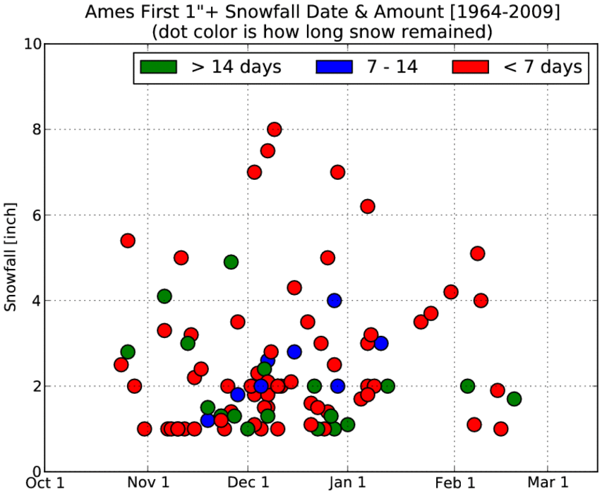
Does the first snow stick around?
08 Dec 2010 05:47 AMWith folks in Ames and Des Moines anxiously waiting for our first snowfall of the season, one may wonder how long our new snowfall will stick around? The featured chart presents the date and amount of the first snowfall for Ames of the winter season. The dot's color represent how long measurable snow depth was observed after the initial snow fall. Last year, our first snow fall (around this date) stuck around until mid March! Most of the dots are in the 1-7 day range, so perhaps our first taste of snow will be brief like most years!
Voting:
Good: 16
Bad: 2
Tags: snowcover snow

First Flakes of Fall
28 Oct 2010 05:52 AMThe first snow flakes of the season where reported yesterday afternoon over extreme northwest Iowa thanks to our large storm system to the north. The featured chart presents the first fall occurence of snow as reported by the sensors at the larger Iowa airports and the human COOP observers. The average first occurence is around the first of November, so yesterday's snow is nothing exceptional. The winds are finally expected to die down some this evening with the coldest night of the season on the way for tonight.
Voting:
Good: 44
Bad: 4
Tags: climate snow 2010

Record December
31 Dec 2009 06:14 AMThe featured image presents preliminary snowfall totals for this December along with the previous record for the month and the all-time monthly record. Sioux City broke their monthly snowfall total record by 3 inches and Des Moines' total places it second all-time. Waterloo did not break either record as their total was well short of the 34 inches back in December 2000. It has been a brutal winter thus far and the next few weeks look to be bitterly cold, but not as snowy.
Voting:
Good: 13
Bad: 9
Tags: dec09 snow

Late March snowfall not uncommon
28 Mar 2008 07:09 AMThe featured chart is the frequency of 1+ inch snowfall observations for some location in Iowa. For a day in late March, about 1 in every 3 years has a recorded snowfall. The chance of a snowfall drops off rapidly in April, but it still can happen! Knowing this winter, it will probably snow all April as well.
Voting:
Good: 28
Bad: 10
Tags: snow

Snow going to stick around?
07 Dec 2007 07:35 AMThe featured chart plots daily high temperature distributions for days on and after a 4 inch+ snowfall grouped by December and February. The chart is an indirect attempt to evaluate how common above freezing air temperatures are after a significant snowfall. The first thing you may notice is the sharply lower and less variable temperature distribution that happens the immediate next day after a snowfall. This is due to the common cycling of low and high pressure systems, so the day after a snowfall is often characterized by a high pressure system that clears out the skies allowing maximum heat loss at night and a cold air mass during the day. The daily means are connected by the blue line which shows the impact of climatology as daily temperatures are warming in February, while slightly negative in December. The actual forecast for the next 7 days calls for sub freezing temperatures for most of the state, so the snow will be around and potentially added to with more storms on the way.
Voting:
Good: 33
Bad: 10
Tags: snow