Link: https://mesonet.agron.iastate.edu/wx/afos/p.php?pil=PNSWSH&e=202204072130
Since about 2003, the IEM has been generating various products derived from raw "Level III" National Weather Service (NWS) NEXRAD Radar data. This processing is based on an internet feed of data provided by the NWS NOAAPort satellite broadcast. Over the years, this feed has had changes impacting how the IEM generates these products. The altruistic goal is to try not to break downstream users of the IEM, but there will be some breakage with this change.
This news item references an announced change by the NWS to discontinue some Level III products disseminated over NOAAPort. Their two valid reasons for doing so are to 1) conserve bandwidth over their satellite broadcast, and 2) generally compatible and higher resolution products are being made available in their place.
The most significant change here for the IEM is the removal of "N0Q" (8 -bit ~1km base reflectivity). In its place, the "N0B" product is also 8-bit, but at ~0.25km resolution. So the IEM has to make some life choices here as to what to do! There's two main products impacted here:
Single RADAR 'Ridge' Imagery
The "N0Q" single RADAR images will stop being produced with "N0B" images created. Presently, both are being produced to allow for a transition period. This removal of N0Q is presently scheduled on 10 May 2022 per the aforementioned NWS announcement.
NEXRAD Mosaics
The IEM mosaic services are heavily used downstream and there is some corollaries to what was done when N0R was discontinued. So the plan right now is to continue to label various services and files as "N0Q", but use "N0B" within the mosaic processing as the raw data source. This N0B data source would then be used as the upstream source for the continued N0R (4-bit base reflectivity) mosaic. So the goal here is no change/impact for downstream users.
Perhaps at some point in the future, a smarter nomenclature will be used for these services to more future proof changes, but we shall kick the can for a while longer! As always, please reach out with any questions / concerns.
Updated 13 Apr 2022: The N0Q mosaic is 0.005x0.005 degrees in resolution, so the change to use N0B (~0.25km vs ~1km) as the data source will result in an enhancement / increase in file size with more data resolution now possible. Here is a GIF showing a before and after mosaic.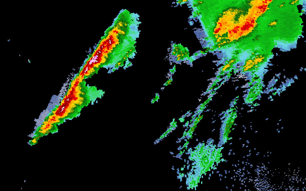
Updated 18 Apr 2022: At about 8 AM (13 UTC), the generation of the N0Q mosaic is now based on N0B data.
Updated 17 May 2022: The NWS appeared to just remove aforementioned products from NOAAPort.
Updated 18 May 2022: An unconsidered by me problem was discovered with the N0R generation due to the removal of NET. This problem is now fixed with a process to repair the broken N0R archive since about 12z yesterday morning.