Past IEM Features tagged: spc

Hatched Tornado Risk
16 Apr 2024 05:37 AMThe Storm Prediction Center issues a number of products including a convective outlook, which provides a spatial analysis of severe weather risk. For the "Day 1" product, individual threat risks are forecast for tornadoes, damaging wind gusts, and hail. On the SPC website, one of the risk categories is colloquially known as the "hatched" risk as it is visually presented as a hatched area on the map, when forecast. This area represents the possibility of significant tornado, wind, or hail risks. For Iowa today, the present Day 1 outlook has much of Iowa within such a hatched risk for tornadoes, meaning a likelihood of EF2 and stronger tornadoes. The featured chart looks at the frequency and yearly period of such a risk threshold for Iowa. The right hand side denotes the first and last date each year along with the number of dates with such a risk threshold present. For Iowa, these events are thankfully only about a handful of times per year. The year 2021 is certainly an outlier with the only event being associated with the serial derecho on 15 December.
Voting:
Good: 13
Bad: 0
Tags: spc

Marginal Risk
08 Feb 2024 05:39 AMThe Storm Prediction Center presently has a day 1 Marginal Risk of severe convective weather for far eastern Iowa, southern Wisconsin, and northern Illinois. This categorical risk threshold was added back in 2015 as something slightly lower than their "slight" threshold. Today's marginal risk area just barely clips the NWS La Crosse County Warning Area (CWA) and the featured chart presents the period each year between the first and last marginal risk. The red tick bars represent individual dates with a marginal risk. With a limited period of record, only last year had an earlier date of 16 January. While severe weather seems very unlikely for Iowa, very warm temperatures for the second week of February are very likely with highs in the lower 60s for some!
Voting:
Good: 12
Bad: 1
Abstain: 1
Tags: spc

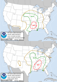
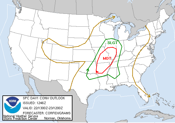
Here we go again
04 Apr 2023 05:43 AMThe featured map presents the current Storm Prediction Center categorical outlook for today. The outlook looks remarkably similar to outlook for last Friday with a large moderate risk centered over southeastern Iowa. The timing and storm coverage is expected to be somewhat different this time, but the chance of a very strong and long lasting tornado appears likely. The storms are expected to get going much later in the afternoon and even after dark than compared with Friday, which will make things even more dangerous. Hopefully this forecast can not verify as nobody wants to see a repeat of the horrible storms from last Friday.
Voting:
Good: 23
Bad: 0
Abstain: 1
Tags: spc

January SPC Outlook
16 Jan 2023 07:03 AMFor a number of recent days, some weather forecast models were showing a rather robust environment to support severe convective storms in Iowa today. Thankfully, the threat appears to have backed off considerably now and the Storm Prediction Center has just a general thunder "TSTM" risk for much of the state today. The featured info graphic displays the number of days since a given SPC Day 1 Convective Outlook threat category for Iowa during the month of January. Of course, it is very rare to have severe thunderstorms in Iowa during January as everything is usually too cold and surface moisture is limited by cold temperatures. The weather forecast focus turns to a significant snow storm arriving Wednesday!
Voting:
Good: 12
Bad: 0
Tags: spc

November Moderate Risks
29 Nov 2022 05:26 AMThe Storm Prediction Center has a convective moderate risk issued for today over portions of Mississippi and surrounding states. The featured map presents a heatmap of such "day 1" moderate risks during November based on unofficial IEM archives. Such events during November are rather rare with only 15 events found since 2002, but this is the second event for this November with the other happening on 4 November. The heatmap nicely shows the two areas of enhanced severe weather climatology for this time of year as they are favored battle grounds between warm/moist and cold air masses. Iowa will be miss out on the severe weather today with snow expected over northern Iowa and a quick drop in temperatures that will likely cause travel headaches.
Voting:
Good: 13
Bad: 0
Tags: spc

Streak of Slight Risk
21 Jun 2022 05:33 AMAs of the time publishing this featured chart, the Storm Prediction Center has just a marginal risk of severe weather forecast as the highest risk category for today over the contiguous US. If this were to hold through the day without any upgrades to a slight risk, it would be the first time since 25 April without at least a slight risk forecast. Of course, April through June are the prime months for severe weather in this country, so having such a streak this time of year makes sense. The featured chart presents the maximum risk category since 1 March this year. An obvious question is has such a streak happened before? Unfortunately, an answer is not straight forward as the threat categories have slightly changed over the years.
Updated: SPC issued a slight risk with the 11:30 AM update, so the streak continues for another day!
Voting:
Good: 18
Bad: 1
Tags: spc

April Hatched Tornado Risk
12 Apr 2022 05:15 AMThe Storm Prediction Center (SPC) is most known for it's categorical outlooks of severe weather (ie slight, moderate, high risk), but they also break those outlook risks into probabilities by threat type (ie hail, wind, and tornado). The "significant" (sometimes called "hatched" since it appears as a hatching on the various SPC maps) overlay to the threat probabilities indicates an area with a threat to see very violent tornados (EF2 and stronger). Today's day 1 outlook issued early this morning has such a hatched tornado threat risk over Iowa today. The featured map presents the number of such day 1 events since 2002 during April. These events are somewhat rare for this far north during April with only a handful of events or fewer on record for the state. The threat today is conditional and is not a foregone conclusion, but the combination of needed ingredients are in place to support strong tornadoes.
Voting:
Good: 16
Bad: 2
Tags: spc

SPC Outlooks this Winter
16 Mar 2022 04:59 AMThe ongoing drought situation in Iowa and elsewhere continues to be of concern as significant rains from thunderstorms has been illusive. One proxy for this dearth of thunderstorms is today's featured calendar showing daily maximum Storm Prediction Center (SPC) convective outlook category for Iowa since 1 December. While this period encompasses the coldest portion of the year during which one does not necessarily expect thunderstorms, the lack of even the modest "General Thunderstroms" (TSTM) outlooks is noticeable and particularly as we head into March, which is start of thunderstorm season. The near term forecast does not look to improve this trend any with significant storm systems staying off to our south. As an addendum, this chart shows the remarkably isolated and anomalous events of 15 December (serial derecho) and 5 March (EF4 Tornado). So by some metrics, this winter has seen way above average severe weather, but not necessarily lots of rounds of thunderstorms, which also bring needed rainfall.
Voting:
Good: 9
Bad: 1
Tags: spc

SPC Day 2 Wind Outlook
09 Aug 2021 02:38 PMMost Iowans need not be reminded that tomorrow is the one year anniversary of the 2020 Derecho! Sadly, it appears that Mother Nature is gearing up to provide a repeat performance, but hopefully not near the scale nor magnitude of the 10 August 2020 storm. The featured map presents the "Day 2" convective outlook from the Storm Prediction Center for damaging wind probabilities with an area of 30% hatched probabilities (hatching implies 75 MPH winds and higher). Ample energy will be present in the atmosphere thanks to very hot and humid conditions that have overspread the area today. It remains to be seen how this event will play out as thunderstorms developing later today and overnight will mess with the environmental available for severe storms on Tuesday.
Voting:
Good: 7
Bad: 0
Abstain: 1
Tags: spc

High Risk Frequency
17 Mar 2021 06:05 AMA significant severe weather outbreak is expected from Arkansas/Louisiana to Alabama today with the Storm Prediction Center issuing its highest threat category for its categorical "Day 1 Convective Outlook" of "High Risk". The featured map presents the frequency of High Risk according to unofficial IEM data back to 2002 valid for the morning issuance. These events are rather infrequent with the highest values shown over northeastern Kansas with a rate of about one per every 3 years. The last high risk covering any portion of Iowa was back on 3 June 2014.
Voting:
Good: 19
Bad: 1
Abstain: 1
Tags: spc

October Slight Risk
22 Oct 2020 05:45 AMHow is Iowa's weather week going in this lovely year of 2020? We go from a heavy snowfall event to much warmer temperatures today and a chance of severe thunderstorms this afternoon. The Storm Prediction Center has portions of eastern Iowa in a "Slight Risk" for severe weather today. The featured chart presents the climatology of such a risk category during the month of October. Today's risk area coincides with the highest frequencies found in the state. The highest values shown are only at about one day per October per year, so these are somewhat rare events.
Voting:
Good: 12
Bad: 1
Tags: spc

First Day 2 Slight of 2020
18 Mar 2020 05:25 AMSevere Weather Awareness Week is not until next week in Iowa, but our first bout with spring time storms is forecast for tomorrow. The Storm Prediction Center has much of Iowa forecast for a "Slight Risk" (SLGT) on Thursday making for the first such risk level this year as shown by the featured calendar. The days shown in green as TSTM are a lesser risk category known as "General Thunderstorms". These early spring season events tend to be limited by the amount of instability that can build in the atmosphere, so we shall see how much sunshine we receive before storms fire.
Voting:
Good: 9
Bad: 0
Tags: spc

Second Slight Risk for Iowa
17 Apr 2019 05:36 AMThunderstorms and severe convective weather have not been that common so far this year for Iowa. Of course, it is early in the season. The featured calendar displays the highest Storm Prediction Center convective risk over some portion of the state so far this year. Today we are under a slight risk and that makes for the second so far this year. The one last week barely scraped western Iowa, so this is the first threat for the state so far.
Voting:
Good: 9
Bad: 0
Tags: spc

Low SPC Watch Total
09 May 2018 05:32 AMWhile there have been a few active days this year, the severe weather season has been rather quiet to date thus far. The featured chart depicts the number of Storm Prediction Center issued Severe Thunderstorm and Tornado Watches for the year to date period each year since 1997 (start of modern period of record). This year's total is just about half the total of the previous lowest accumulation year.
Voting:
Good: 12
Bad: 0
Tags: spc 2018

10% Tornado Risk
20 Apr 2017 04:12 AMWith the late morning update yesterday, the Storm Prediction Center had a 10% tornado risk analyzed over parts of Iowa for Wednesday. Thankfully, only a few brief tornadoes were reported near Carroll. The 10% risk threshold only happens a few times each year as highlighted by the featured plot. The map presents the average yearly frequency of having a 10% risk threshold issued. The values for Iowa are in the 1 to 3 days per year range. Kind of interesting to see the highest frequencies show up in the eastern portions of the traditional "Tornado Alley".
Voting:
Good: 7
Bad: 0
Abstain: 1
Tags: spc tornado

Day 1 Slight Risk Climatology
14 Apr 2017 05:33 AMThe Storm Prediction Center issues risk categories and probabilities for severe weather for days (24 hour windows of time) 1 through 8. The featured chart looks at the frequency of having the slight risk category issued for "Day 1" from SPC's morning issued outlook. Interestingly enough and according to this unofficial IEM analysis, the highest frequencies in the USA can be found here in Iowa and parts of extreme eastern Nebraska. The SPC outlooks cover threats from large hail, damaging winds, and tornadoes. So while Iowa does not see the most tornadoes in the country, it does see its fair share of all severe weather threats. Iowa is effectively in a sweet spot for severe weather, including night time thunderstorms that bring hail and wind fueled by the low level jet and Mesoscale Convective Complex activity. The values on the plot are average number of slight risk events per year. Such a event is expected on Saturday with a "Day 2" slight risk currently in effect.
Voting:
Good: 24
Bad: 2
Abstain: 1
Tags: spc

Last Moderate Risk
05 Apr 2017 05:36 AMThe Storm Prediction Center has a large portion of the SE United States under a moderate risk of severe weather for today. The featured map presents an IEM analysis of the most recent year of having a moderate risk issued for map location. For most of Iowa, you have to go back to the year 2014 since the last issuance. This year has seen a number of moderate risks issued over parts of the country as the very active start to the severe weather season continues.
Voting:
Good: 12
Bad: 0
Tags: spc moderate

Tornado Watches into Warnings
30 Mar 2017 05:33 AMContinuing with the theme of Severe Weather Awareness Week in Iowa this week, yesterday was the statewide tornado drill with a test watch and warning issued for the entire state. Today's featured chart looks at the conversion of counties under a tornado watch into a tornado warning. For example, if a tornado watch was issued for 60 counties and 30 of those counties received a tornado warning, that would count with the 50% bin for the plot. About 20% of all tornado watches receive no subsequent warning. Most watches have less than 30% of the counties included eventually get a warning. Thankfully, tornadoes typically are not widespread and limited to a couple of high end storms during a typical watch. Hopefully that is the case today with a significant tornado threat expected over the southern US.
Voting:
Good: 7
Bad: 0
Abstain: 1
Tags: nws spc tornado watch

SPC Watch Issuance Confidence
29 Mar 2017 05:36 AMContinuing with the theme of this week being Severe Weather Awareness Week in Iowa, today's featured plot looks at an analysis of convective watch issuance verification based on probabilities included in Mesoscale Convective Discussions (MCD) issued by the Storm Prediction Center (SPC). The SPC issues the MCD product to provide a short term update and analysis of the storm scale environment during active weather. Prior to most tornado or severe thunderstorm watch issuance, the SPC typically issues a MCD to highlight an area of interest and provides a confidence percentage on if a new watch may be soon issued. The association of an issued watch and the MCD product is not exact, so a simple algorithm was used with reasonable defaults to provide a verification of these percentages. The algorithm being the new watch needed to be issued with 2.5 hours and at least 50% of the watch polygon had to overlap with the MCD polygon. What is the moral of the story? Well, the high confidence MCDs typically get an issued watch, the lower confidence ones typically do not. The next time you read a MCD product from the SPC, check out the confidence noted and see if a subsequent watch is issued!
Voting:
Good: 6
Bad: 0
Tags: nws spc mcd watcfh

Fewest Watches
08 Nov 2016 05:35 AMThe featured chart displays the number of year to date Severe Thunderstorm and Tornado Watches issued by the Storm Prediction Center since 1997. The top panel displays the number issued nationwide, the middle panel shows the number that had any part of the initial watch outline overlap Iowa, and the bottom panel shows the percentage of watches that overlapped Iowa for that year. This year's total is a mere 52, which is the lowest found within the modern database. It is interesting to see each of the past five years show up in the least number of watches for the period.
Voting:
Good: 4
Bad: 1
Tags: spc watch

Second Moderate Risk Day
30 Jun 2014 05:46 AMThe Storm Prediction Center has had Iowa in a moderate risk for severe weather for two days in a row now. A few tornadoes were reported in Iowa on Sunday and more are expected today. Heavy rainfall will be a problem again with expected over two inches for parts of eastern Iowa. A severe thunderstorm watch is already in effect this Monday morning with storms rolling across northern Iowa.
Voting:
Good: 15
Bad: 6
Abstain: 5
Tags: spc

SPC Watches
23 Apr 2014 05:36 AMThe Storm Prediction Center issues Tornado and Severe Thunderstorm watches. The featured chart displays the number of watches issued for the year to date period since 1997 and the percentage of total watches that have some coverage over Iowa. It has been rather quiet for severe weather activity nationwide, but that looks to change starting today with a number of rounds of severe weather expected over the coming days.
Voting:
Good: 15
Bad: 5
Abstain: 1
Tags: spc

October Moderate Risk
04 Oct 2013 05:45 AMThe Storm Prediction Center has a moderate risk of severe weather over much of Iowa today including the threat of tornadoes. Having such a threat is somewhat rare for Iowa and even more so when you consider the calendar says October! The powerful storm system bringing this threat is also expected to dump many inches of snow just to our northwest in South Dakota. The air on backside of this system will be a sensible change with highs only in the 50s for the weekend and more chances of precipitation.
Voting:
Good: 86
Bad: 5
Tags: spc

Watch Frequencies
20 Jul 2013 07:50 PMA number of severe thunderstorm watches have been issued today by the Storm Prediction Center (SPC). None of these in Iowa though. Anyway, the featured chart presents the daily frequencies of SPC issued watches and the ratio between the number of severe thunderstorm versus tornado watches issued. Both have clear annual signals with their respective peaks happening at different times of the year. The largest number of watches (dots) occur during the strongest battles of the air masses during the spring season. The bars shows the ratio of severe thunderstorm versus tornado warnings. This ratio peaks out during the first two weeks of August as temperatures are the warmest over the United States and the cool air masses are well north leading to less wind shear in the atmosphere.
Voting:
Good: 74
Bad: 7
Tags: spc watch

October Severe Weather
12 Oct 2012 05:35 AMThe big weather story this week is the predicted severe weather outbreak arriving this weekend. The featured image is forecasted severe weather threat categories from the Storm Prediction Center for Saturday. Much of Iowa is in the slight risk category. Typically, these fall severe events are conditional on heating of the lower atmosphere, so seeing the sun shine on Saturday would be a bad omen as it would help to fuel thunderstorms later in the afternoon.
Voting:
Good: 61
Bad: 16
Tags: spc

Six days of Slight Risk
06 May 2012 11:14 AMToday (Sunday) will end our streak of having the Storm Prediction Center forecast slight risk of severe weather in Iowa. The featured image displays the categorical outlook issued each day at 7 AM. We have one more round of severe weather to go this afternoon and evening before the weather straightens out some this coming week. It would be good to see a dry stretch of weather to help get the agricultural crops planted in the state.
Voting:
Good: 67
Bad: 6
Tags: spc may12

Severe Weekend
13 Apr 2012 05:58 AMThe Storm Prediction Center has a rare high risk of severe weather forecasted for Saturday with portions of Iowa included in a moderate risk. This risk is due to the combination of springtime instability and strongly sheered wind profiles (winds changing direction and/or speed with increasing height in the atmosphere). This environment supports classic and long-lived supercell thunderstorms. Besides the severe weather, Iowa is also expected to pick up some much needed rain with many locations expected to get much more than an inch of rain.
Voting:
Good: 64
Bad: 34
Tags: spc

Large Moderate Risk
02 Mar 2012 05:57 AMAfter a punishing year of severe weather in 2011, this year appears to be attempting a repeat. The Storm Prediction Center has a very large area outlined for a moderate risk of severe weather today and into Saturday morning. This storm closely follows a deadly storm system on Wednesday that brought tornadoes to Kansas, Illinois and other states. Iowa will miss the severe weather and perhaps get a bit of snow.
Updated the feature graphic to show the 11:30 AM outlook with the high risk.
Voting:
Good: 35
Bad: 4
Tags: spc

Watches by year
16 Nov 2011 05:57 AMThe past few days have seen bouts of severe weather over various parts of the country. The Storm Prediction Center issues tornado and severe thunderstorm watches in advance of these storms. The featured chart presents the year to date totals of watches issued for Iowa and Texas since 1997. Last year was the only year Iowa has beaten Texas in total watches. The bottom chart shows the percentage of total watches issued that covered a portion of Iowa. This year's percentage is the second lowest behind 1997.
Voting:
Good: 11
Bad: 5
Tags: spc

Tornado Watches and wind
12 Jul 2011 06:19 AMThe featured chart presents an analysis of averaged surface wind speed and direction over the domain of a Storm Prediction Center issued tornado watch that was centered over Iowa. The wind values are for a period near issuance. The symbols represent the number of tornadoes reported within the watch box. The plot nicely shows that winds from the southeast to southwest are the most common with a sharp cutoff at the southwest direction. Tornadoes form in environments of wind sheer where wind speeds and/or direction change with increasing height in the atmosphere. So having surface winds out of the southeast and upper level winds out of the west provide the sheared environment in Iowa.
Voting:
Good: 17
Bad: 9
Tags: spc tornado

Busy Monday
20 Jun 2011 05:55 AMThe Storm Prediction Center has a moderate risk of severe weather forecasted for portions of Iowa today. This is thanks to a spring like storm system that will move out into the plains today. The passage of this system will usher back in cold air for this time of year with highs only in the 60s later this week!
Voting:
Good: 17
Bad: 3
Tags: spc

A month faster than last year
27 Apr 2011 07:39 AMThe nation's recent stretch of severe weather continues with a high risk of severe weather issued today over portions of Alabama. The Storm Prediction Center has issued its 228th watch of the year this morning. Last year, it took until the 27th of May for the 228th watch of the year to be issued as shown by the featured chart. Three other years since 1997 have seen more watches issued by this date than this year.
Voting:
Good: 8
Bad: 3
Tags: spc

three months down, nine to go
01 Apr 2011 05:54 AMThe featured chart presents the yearly number of SPC issued watches before and after 1 April. This year has seen about twice as many watches to this date than last year, but only half the total of 2008 and one of the smaller totals since 1997. The largest total of watches on this chart (2003) started off with a near average total prior to 1 April. Chances of severe weather arrive in Iowa on Sunday and hopefully some warmer weather as well.
Voting:
Good: 20
Bad: 8
Tags: spc

First moderate risk of the year
24 Feb 2011 05:58 AMThe Storm Prediction Center has issued a moderate risk of severe weather for today. This is the first such issuance this year. If the IEM archive is correct, the first moderate risk last year was not until the 22nd of April. Tornadoes and damaging winds are expected.
Voting:
Good: 18
Bad: 4
Tags: spc

Slight risks return
25 Oct 2010 05:09 AMThe Storm Prediction Center issued a slight risk of severe weather over Iowa this past Saturday making for a month since the last such issuance for Iowa. The featured graph presents the daily areal coverage of slight convective risk over Iowa for this year and last. Interesting to see lack of slight risk from the middle of August 2009 until April of this year. Slight risk of severe weather is over the state again for Monday with this week representing a major change from the weather we have seen for the past month.
Voting:
Good: 37
Bad: 11
Tags: spc

Watching more than Texas
16 Sep 2010 05:56 AMThe Storm Prediction Center issued another watch for Iowa yesterday making for the 113th watch issued this year that covered portions of Iowa. The featured graph displays the number of watches year to date issued for Iowa and Texas. This is the first year since 1997 that Iowa has seen more watches. The bottom graph displays the percentage of all watches issued that cover a portion of Iowa. This year has seen the highest percentage! Another reason why 2010 has been an exceptional year.
Voting:
Good: 33
Bad: 5
Tags: 2010 spc

Tornado threat to end April
30 Apr 2010 08:06 AMThe first four months of the year have been very quiet for tornado activity in Iowa. The Storm Prediction Center has a slight risk of severe weather out for Friday with considerable tornado probabilities forecasted for this afternoon as shown by the featured map. Storms should get going early this afternoon and then race eastward at over 50 miles per hour. All of this nasty weather will sweep east and leave us with a very nice weekend to start off May!
Voting:
Good: 40
Bad: 24
Tags: spc
Severe weather returns
23 Apr 2010 05:11 AMAfter a rather quite start to the severe weather season, a large storm system to our west will cross the plains today and this weekend bringing wide spread severe weather. The featured composite image is the Storm Prediction Center forecast for Friday and Saturday. Iowa is under a slight risk for both days with expansive moderate risk shown over the southern plains.
Voting:
Good: 79
Bad: 16
Tags: spc

June starts off with a bang
01 Jun 2009 05:35 AMThe Storm Prediction Center has most of Iowa outlined in a slight risk for severe weather today as strong storms are expected to develop this afternoon along a stalled out boundary bisecting the state. The biggest threat may be the heavy rain expected as storms will not be in a hurry to move anywhere and will tend to train over the same areas. All of this makes for an active start to June after a rather calm last half of May.
Voting:
Good: 17
Bad: 3
Tags: spc

VORTEX2 Buzzkill
27 May 2009 05:57 AMVORTEX2 is the code name for a large scientific field project to measure stormscale environments around tornadic storms. The project has been out chasing storms since about the 10th of May, but has had very little organized severe weather to work with. In fact, the dearth of severe weather for this time of year is rather unprecidented. The featured image displays the daily number of SPC issued watches for May since 1997 (oldest date of digital records). Areas of white indicate no watches issued and you can see the drought of 2009 is largest area on this plot. Greg Carbin of SPC wrote an interesting blog post on how rare this quiet period of May has been. Based on forecast models, business for the VORTEX2 project appears to be picking up with a more organized severe weather expected.
Voting:
Good: 27
Bad: 7
Tags: spc

Watching for hours
15 May 2009 06:14 AMThe featured map is the number of hours counties have been under either a severe thunderstorm or tornado watch this year. While Iowa has generally seen less than 24 hours of total watch time, the areas in red indicate counties over 60 hours (4 and a half days). Some strong thunderstorms are expected today, but the worst of the weather will stay to our south.
Voting:
Good: 41
Bad: 13
Tags: spc

February Slight Risk
09 Feb 2009 06:13 AMThe Storm Prediction Center has issued a slight risk of severe weather today for most of Western Iowa. A spring like storm system will quickly move through the state today with the possibility of hail, strong winds, and even a few tornados.
Voting:
Good: 32
Bad: 5
Tags: spc

Severe weather returns?
23 Sep 2008 07:30 AMThe Storm Prediction Center has Northwest Iowa outlined in a slight risk for severe weather today with the passage of a cold front. It has been a while since Iowa has experienced severe weather, which nobody will mourn over after our wild and rough spring/summer. Temperatures will remain mild, even on the other side of this front for the last week of September.
Voting:
Good: 23
Bad: 8
Tags: spc

And yet another high risk!
05 Jun 2008 08:22 AMThe Storm Prediction Center has a very large high risk of severe weather for today. The atmospheric setup has many of the severe weather indices pegged with extreme amounts of wind shear and instability present. Perhaps the most concerning threat is the flooding potential with any additional rain producing flooding. Needless to say, the active weather pattern continues.
Voting:
Good: 30
Bad: 7
Tags: spc

Everybody on edge
29 May 2008 08:19 AMThe Storm Prediction Center has issued a high risk of severe weather for Thursday. The atmosphere over Eastern Nebraska and Western Iowa will be primed for a severe weather outbreak with large amounts of instability juxtaposed over strong wind sheer (which helps the thunderstorms to rotate). The particularly dangerous aspect of this setup is that the tornado threat is expected to continue after sunset along with a good chance of a widespread damaging wind event. Just what we did not want to see.
Voting:
Good: 20
Bad: 14
Tags: spc

More bad weather
13 May 2008 08:06 AMAn area that was hit hard last Saturday Night is expected by the Storm Prediction Center to experience rough weather again with significant tornadoes possible. For Iowa, we may get a couple of strong storms with large hail being the primary threat.
Voting:
Good: 15
Bad: 8
Tags: spc

May Day Storms?
01 May 2008 08:07 AMThe Storm Prediction Center has a moderate risk of severe weather forecasted just south of Iowa today with most of the state in a slight risk. The primary threat of large hail will arrive late this afternoon and evening, but tornados are possible with a very dynamic storm system developing to our west. The tornado threat on Friday looks to be a bit more significant for folks in Eastern Iowa as this slow moving storm system passes thru.
Voting:
Good: 26
Bad: 4
Tags: spc

3 days of slight risk
20 Jun 2007 06:54 AMThe Storm Prediction Center has Iowa highlighted in a slight risk for the next 3 days. The risk is primarily due to the forecasted development of numerous mesoscale convective systems (MCS) that will thrive off of the deep moisture and drive across the state mainly during the night time hours. This period is also the strongest heating days by the sun, since the days are the longest and the sun is the highest (most direct to ground) in the sky.
Voting:
Good: 21
Bad: 5
Tags: spc

Severe Thursday
07 Jun 2007 07:51 AMIt is hard to not feature the Storm Prediction Center outlook again today. A lid of warm air that suppressed widespread storms in our area yesterday is expected to cool and allow explosive thunderstorm development today. The damaging wind threat looks to be the primary severe weather mode with a chance of a few long duration violent tornadoes and large hail. Please watch the weather closely today.
Voting:
Good: 29
Bad: 8
Tags: spc

Buckle up
06 Jun 2007 07:20 AMThe weather is set to get rough today and tomorrow with an unseasonally strong storm system developing this morning over the high plains. The Storm Prediction Center has parts of Iowa in a moderate risk for both days with the main threat for Iowa arriving on Thursday. The limiting factor for this event may be the amount of rich moisture that is available to be pulled north. This moisture provides the fuel for thunderstorm development.
Voting:
Good: 21
Bad: 4
Tags: spc

Hail threat today
21 Mar 2007 07:14 AMThe Storm Prediction Center has Iowa in a slight risk for severe weather today as a cold front will sweep the state later this evening. The primary threat will be large hail, but if the sun is able to break out during the afternoon, an isolated tornado may be possible as well. The sun provides low level heating which makes for a more energetic environment for thunderstorms to feed off of.
Voting:
Good: 26
Bad: 4
Tags: spc

A moderate risk
03 Oct 2006 08:08 AMThe Storm Prediction Center has a moderate risk of severe weather forecasted for today over most of NE Iowa. Abnormally warm and moist air mass will be in place for explosive thunderstorm development this evening with a very good chance of these storms producing tornadoes.
Voting:
Good: 10
Bad: 2
Tags: spc
Second severe season
22 Sep 2006 08:08 AMThe Storm Prediction Center has a good portion of Missouri, Illinios, and Arkansas under a moderate risk for the chance of tornadoes and damaging winds. After a quiet summer (severe weather wise), the transition to fall has brought a number severe weather outbreaks.
Voting:
Good: 21
Bad: 6
Tags: spc

Active day forecasted
24 Aug 2006 07:19 AMThe Storm Prediction Center has a moderate risk of severe weather forecasted for today. All forms of severe weather appear to be possible along a stalled out warm front just north of the Iowa/Minnesota border. The storm system will eventually slide thru the state on Friday bringing the threat of severe weather south.
Voting:
Good: 17
Bad: 2
Tags: spc

5% Tornado Threat
09 Aug 2006 07:36 AMThe Storm Prediction Center has forecasted a 5% tornado risk for today over all of Western Iowa. The value represents the chance of 1 tornado occuring within 25 miles of any point in the area. Storms will fire along a boundary this afternoon with the chance to produce a few tornados.
Voting:
Good: 8
Bad: 5
Tags: spc

Strong storms today
19 Jul 2006 06:49 AMThe Storm Prediction Center has issued a moderate risk of severe storms for an area just north of Iowa today. A majority of Iowa will be under a very warm layer of air inhibiting storm development. Temperatures will soar into the upper 90s again with high humidities.
Voting:
Good: 15
Bad: 8
Tags: spc

Nice today, bad tomorrow
29 Mar 2006 07:03 AMFor the past week, weather models have been indicating a severe weather situation unfolding on Thursday with a significant outbreak possible across the plains. The featured plot from the Storm Prediction Center highlights this risk area with further revisions and categorical upgrades today. But for today, temperatures will finally climb above normal with a very spring like feel.
Voting:
Good: 28
Bad: 8
Tags: spc

Severe Weather Saturday?
11 Nov 2005 07:12 AMThe Storm Prediction Center has a slight risk of severe weather analyzed for Iowa on Saturday. A strong cold front will approach the state and should kick off some thunderstorms late Saturday afternoon. The main threat appears to be gusty winds. Temperatures will continue to be very warm with highs in the mid 60s.
Voting:
Good: 36
Bad: 21
Tags: spc

Stormy Friday
19 Aug 2005 07:16 AMThe Storm Prediction Center has a slight risk of severe storms forecasted for all of Iowa on Friday. Strong storms will develop and push east overnight. The main threats appear to be hail and wind, but a few tornadoes are possible as well. After the storms, this weekend looks amazing with sunny skies and comfortable temperatures.
Voting:
Good: 19
Bad: 9
Tags: spc

Moderate risk today
29 Jun 2005 07:16 AMThe Storm Prediction Center has forecasted a moderate risk of severe weather over the NE quarter of Iowa. There is also a moderate feeling of uncertainty with storms/clouds already in the state this morning and the chance that these storms could persist through the day. If this happens, the significant severe weather threat would shift south into Southern Iowa. Either way, the weather bears watching today.
Voting:
Good: 10
Bad: 8
Tags: spc

Unsettled weather continues
13 Jun 2005 07:16 AMThe Storm Prediction Center has a moderate risk of severe weather forecasted for Eastern Iowa, SW Wisconsin, and Illinios for today. A strong surface low pressure system to our west will combine with a upper atmosphere jet to provide the spin necessary to produce rotating storms which lead to large hail and possibly tornados. A break to this pattern is in the forecast with 3 days of dry weather forecasted after Wednesday.
Voting:
Good: 14
Bad: 6
Tags: spc

Two chances
10 May 2005 06:49 AMThe Storm Prediction Center has Iowa within the slight risk probability zone for severe thunderstorms today and tomorrow. Disregarding the hail and wind threat, the real threat looks to be flooding rainfall from slow moving storms. Some locations will easily pick up more than 3 inches of rain. Southern Iowa can withstand a couple inches of rain without major issues, but Northern Iowa has received heavy rain recently and would have a more difficult time absorbing more water.
Voting:
Good: 12
Bad: 2
Tags: spc

Marginal Threat
05 Apr 2005 08:17 AMThe Storm Prediction Center has a small portion of Western Iowa in a slight risk for severe convection for storms that are expected to fire late this evening. The limiting factors today will be a considerable layer of warm air just above the surface (cap) and limited surface heating due to clouds. As with most springtime storm systems, the dynamics are strong enough to overcome some of these limiting factors. Having said all that, the best chance for severe weather will be to our south.
Voting:
Good: 8
Bad: 2
Tags: spc

Somebody will get it
22 Oct 2004 08:17 AMSomebody refers to folks in the MidWest. It refers to any number of severe weather modes from tornados to hail to wind. The best chances for severe weather look to be in Western Iowa where they should see some sunshine today to help destabilize the atmosphere even further. A surface dry line will approach this area by very late afternoon, which for Iowa, is a very omnious sign for severe weather.
Tags: spc

Big Fat Moderate
26 Aug 2004 08:21 AMThe Storm Prediction Center has put us in a moderate risk for severe weather this afternoon and evening. Severe weather parameters are coming together very nicely today for a statewide outbreak of severe weather. Iowa will probably add to its already gaudy total of tornadoes reported for the year.
Tags: spc

Extremely Dangerous Situation.
24 May 2004 07:32 AMMonday could be a repeat of the weather Iowa experienced on Saturday. This repeat performance, unfortunately, appears very likely with an even better chance of long lived and destructive tornados. The hope is that the heaviest rainfall occurs to the south of I-80, which would avoid having heavy rainfall in areas that can not withstand any more rainfall. It will be a long day.
Tags: spc

Perpetual Slight
21 May 2004 08:17 AMSeems like the Storm Prediction Center has had us in the slight risk category for the entire week. A frontal boundary has been waffling (hmmm, waffles) around the state and has been a pesky boundary for forecasters to predict. Severe weather chances will continue as long as we have this feature in the state.
Tags: spc

Explosive Convection
19 May 2004 08:16 AMJust about every storm chaser in the midwest will probably be in E Nebraska / W Iowa this afternoon. The atmosphere is primed for an explosive convective event today. Numerous long lived super cells are possible with some of these cells producing tornados.
Tags: spc

Slight Risk
06 May 2004 07:32 AMThe Storm Prediction Center has placed most of Iowa in a slight risk for severe weather today. Thunderstorms are expected to fire along a surface boundary later this afternoon and they have the potential to be severe.
Tags: spc

Moderate Risk
14 Jul 2003 07:36 AMThe Storm Prediction Center has placed most of Iowa in a moderate risk for severe weather today and tonight. Thunderstorms will fire this afternoon and continue on this evening.
Tags: spc