Past IEM Features tagged: hail

Source of Hail Reports
28 Sep 2023 05:30 AMWhile RADAR provides NWS Meteorologists with high spatial and temporal resolution data of storms, it misses what's happening at the ground surface due to beam tilt and curvature of the Earth (sorry flat-earthers). RADAR also can not explicitly determine hail size that is reaching the ground, so the NWS is heavily reliant on folks to report to them hail size received. When the NWS receives such a report, they often disseminate that observation in the form of a "Local Storm Report" (LSR). The LSR product contains a classification of whom the report is sourced from. The featured chart presents a yearly accounting of these source classifications for hail reports nationwide. The sources are ranked each year for the number of reports received with a line connecting each source type between the years. The top two most frequent sources have not changed over the past eighteen years, but their ordering has. The reason is likely to do with NWS software changes for how LSRs are created with "public" being the current default source and also an increase in social media / NWSChat reports that get lumped into that classification as well. The actual "social media" classification is not extensively utilized, so most reports from there get lumped into public. Anyway, the IEM offers a shapefile download of these LSR reports.
Voting:
Good: 10
Bad: 0
Tags: lsr hail

Prolific Hailer
10 Jul 2021 07:04 AMA super cell thunderstorm developed into quite the prolific hail producer early afternoon on Friday with the featured map combining maximum estimated hail size by the NOAA MRMS project and available NWS Local Storm Reports. This map is zoomed in on about a four county region including Des Moines and to its north and west. The largest report received so far is 3.25 inches from Windsor Heights (suburb of Des Moines). The MRMS product aligns nicely with the received reports with a caveat being that this storm was right over-top the Des Moines NEXRAD location in NW Polk County, so algorithms may have struggled some. The "generate plot" link for this feature takes you to a viewer of the Local Storm Reports for this event.
Voting:
Good: 14
Bad: 2
Tags: hail mrms

2020 Severe Hail Reports
27 Nov 2020 06:10 AMThe featured map presents unfiltered totals by NWS forecast office of one plus inch hail reports from NWS Local Storm Reports (LSRs) for this year. It is interesting to denote the highest total is found with Rapid City, SD just edging out Norman, OK. The generation of severe hail requires robust convection driven by strong instability. Such instability is favored during the summer season over the region east of the Rocky Mountains as warm and moist air from the Gulf of Mexico near the surface interacts with colder air aloft and lifting mechanisms associated with mountain interactions.
Voting:
Good: 15
Bad: 0
Tags: hail

3 inch Hail
15 May 2020 03:29 AMA powerful storm just south of Des Moines dumped large hail up to three inches in diameter Thursday afternoon. The featured map presents a preview of an upcoming hail size estimate product produced by the IEM based on NOAA MRMS MESH along with available NWS Local Storm Reports centered over southern Iowa. The MESH product uses RADAR data and algorithms to produce estimates of maximum hail size. The three inch report aligns well with the estimated maximum in the product. The data presentation shown is not yet available on the website for generation, stay tuned!
Voting:
Good: 15
Bad: 1
Tags: mesh hail

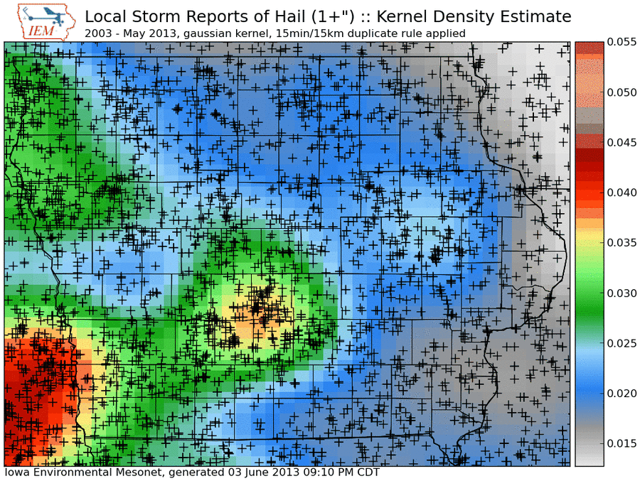
Hail reports
04 Jun 2013 05:48 AMThe featured map presents an analysis of National Weather Service Local Storm Reports (LSRs) of one inch plus diameter hail since 2003. The analysis is a kernel density estimate using a Gaussian kernel and attempts to show the spatial distribution of hail reports. Hail is reported and collected by humans, so it is natural to see urban centers in the state show local maxima for reports. The general pattern is for fewer reports as one travels from southwest to northeastern Iowa. The geography of the Midwest drives the meteorology which favors more instability over the plains. This instability feeds thunderstorm development in the late afternoon hours that tends to produce hail. These thunderstorms then truck it east, congeal and loose their ability to produce hail.
Voting:
Good: 51
Bad: 11
Tags: hail lsr

Cold temps for hail
11 Apr 2013 05:45 AMHaving hail from spring time thunderstorms is not an exceptional event. Having hail while near surface air temperatures are near freezing is exceptional. The featured chart compares recently reported hail size and an approximate surface air temperature from a nearby reporting station. It is remarkable to see so many hail reports at temperatures even below freezing. The thunderstorms were feeding off of instability based well above the surface. Having a cold layer of air near the surface also helped hail stones to reach the ground without mostly melting on the way down.
Voting:
Good: 69
Bad: 10
Tags: hail 2013

Ugly scar
26 Aug 2011 05:53 AMBesides dumping heavy rainfall last week, a cluster of powerful thunderstorms dropped large hail over parts of southwestern Iowa last Thursday. A week later and a clear sky overhead allowed the Terra MODIS satellite to get a good look at the result of the hail storm. These hail scars are easily visible given the contrast of green crops and the hailed on areas whose green leaves were stripped away exposing the brown ground. The featured image combines the satellite image with NWS collected reports of hail size on the 18th.
Voting:
Good: 33
Bad: 8
Tags: satellite hail

Hail time
22 Mar 2011 05:46 AMStorms bringing hail have been frequenting the state these past few days with more expected today. The featured chart presents the frequency of hail observations based on National Weather Service local storm reports since 2003. The top chart shows hail to be most common during the spring and summer months. The bottom chart shows the late afternoon as being the most favored time for hail. The late afternoon is typically when the atmosphere is at its most unstable condition after the sun has heated the ground for most of the day. Hail can occur at any time of day and certainly during the night time hours.
Voting:
Good: 17
Bad: 2
Tags: hail

Another Hail Scar
13 Aug 2009 06:08 AMA few weeks ago, the result of a significant hail storm in Northeast Iowa was featured by showing the impact on vegetation. Another major hail storm left a similar scar over Central Iowa on Sunday and its effect can be seen as well. The featured image transitions from the Terra MODIS imagery to NEXRAD maximum reflectivity composite. Like with the previous feature, you can see the correlation between the highest reflectivites and the damage on the ground.
Voting:
Good: 20
Bad: 5
Tags: satellite nexrad hail

Impressive Hail Damage
30 Jul 2009 12:14 AMLast Friday, an extremely strong thunderstorm complex dropped a bunch of large hail over NE Iowa and SW Wisconsin. The NWS has an excellent summary of this event here and here. The featured image is a combination of Terra MODIS satellite for yesterday and maximum NEXRAD reflectivity for the event. The area shown initially in gray is unfortunately massive crop damage as the green leaves were shredded by the large hail and the area no longer appears to be lush green from space. You can see the streaks in the damage as the storms moved off to the southeast.
Voting:
Good: 39
Bad: 3
Tags: hail nexrad satellite

View larger image
Based on warnings issued by Davenport, La Crosse, Sioux Falls, Omaha, and Des Moines not just for Iowa.
One Inch Hail
27 Mar 2009 05:59 AMOn April 1st, National Weather Service Offices in the Central Region will be changing its severe weather warning criteria for hail size to one inch and larger (previously was penny sized 0.75). Some details behind the reason for this change can be found with this NWS webinar. The featured pie charts attempt to look forward to one probable outcome of this change, a decrease in the number of warnings. Of the 2200 warnings issued in the past two years, 24% of them were verified by only hail stones that would no longer justify a warning. The lower pie chart details the initial justification for issuing the warning based on product text. Please note the warning may have included a justifcation of damaging wind as well as hail, but this analysis only worries about what hail size was included. Half of the warnings issued mentioned hail sizes that will no longer be severe, again there may have been damaging winds mentioned in those as well.
Voting:
Good: 36
Bad: 18
Tags: hail nws

Softball hail!
17 Jul 2007 07:02 AMThe atmosphere was very unstable yesterday and produced a number of vigorous thunderstorms producing high winds, hail, and perhaps a few brief tornados. The featured map is of a very prolific hailer near Waterloo. Numerous reports of golfball and larger size hail were made with this storm. A report of a 4.5 inch hail stone was received from near Janesville!
Voting:
Good: 19
Bad: 4
Tags: hail

Funky looking hail
31 Mar 2006 07:37 AMSevere storms yesterday brough very strong winds, a brief tornado or two, and some very funky looking hail. The featured image taken by Rita Gergely of Des Moines shows one of these hail stones. This stone was formed by a number of smaller stones that fused together on their way to the ground. Another round of severe weather looks probable on Sunday and then again later next week!
Voting:
Good: 44
Bad: 26
Tags: hail

Big Hail
27 Aug 2004 08:22 AMWow, what a afternoon and night on Thursday. The atmosphere was primed for a supercell party and our guests showed up bringing gifts. These gifts are shown in the photo. Baseball size hail was reported in numerous locations along with very gusty winds. Our chances for storms continues today before it quiets down for the weekend.
Tags: hail