Past IEM Features tagged: flood

Mississippi River Flooding
28 Apr 2023 05:30 AMIt was an epic winter for accumulating snowfall to the north of Iowa. Much of this snowfall has melted and is now flowing south via the Mississippi River to produce flooding. It is somewhat fortunate that dry weather in Iowa and elsewhere this month has not added to stream flows. The featured chart presents recent USGS/NWS stage observations and forecasts for Guttenburg (northeastern Iowa). It shows a forecast crest happening Friday/Saturday and then receding afterwards. The crest reaching 21 feet would put it into "major flooding" category. These forecasts make assumptions about expected rainfall and rainfall runoff impacts take time to reach the Mississippi, so near-term unexpected heavy rainfall events and future events currently outside of the forecast window will impact future river stage observations.
Voting:
Good: 18
Bad: 0
Tags: flood mississippi

Historic Missouri River Flooding
18 Mar 2019 03:43 PMThe featured image is courtesy of @CopernicusEU showing a dramatic view of the historic flooding over eastern Nebraska and western Iowa using data from Sentinel 2 satellite. For the gauge at Plattsmouth, Nebraska, the Missouri River is four feet above the previous record stage. The ongoing flooding situation is being helped by mostly dry weather this week, but there is still plenty of snow to melt yet over areas further north.
Voting:
Good: 5
Bad: 0
Tags: flood satellite

Cedar Rapids Flooding
27 Sep 2016 05:15 AMThe big story in the state is the ongoing flooding of the Cedar River in Cedar Rapids. This flooding water is from rainfall last week over northeastern Iowa. The featured chart displays sequential river stage forecasts for the CIDI4 (Cedar River at Cedar Rapids) site. Forecasts are made out a number of days and updated a few times per day during active flow situations. The plot presents each of these forecasts and the observed data for the site. Thankfully the forecasted crests have slowly crept lower with time as the event has gotten closer to town.
Voting:
Good: 9
Bad: 0
Abstain: 1
Tags: flood

More Northeast Iowa Flooding
23 Sep 2016 05:34 AMThe featured map displays MRMS precipitation estimates from noon Tuesday thru noon Thursday for NE Iowa, SW Wisconsin, and SE Minnesota. Amazingly, three different areas are estimated to have received over 10 inches during this period. The heaviest rainfall in Iowa fell near Greene with an actual report of over 10 inches to match the estimates. Sadly, more rain fell in the area overnight and more chances of rainfall are in the forecast for this weekend.
Voting:
Good: 22
Bad: 0
Tags: flood

Turkey River Flooding
26 Aug 2016 05:34 AMThe large rainfall shown in yesterday's IEM Daily Feature resulted in significant flooding. The featured chart today looks at the stage reports from river gauges along the Turkey River in far NE Iowa. The right hand panel shows that the significant rainfall was isolated to the upper portions of the basin with locations to the SE receiving less than an inch. So the surge of water from the rainfall event can be tracked as it flows downstream. The six gauges shown are spatially plotted on the right hand panel with the Spillville location representing the 'start' of the river rise for this analysis. The time when the rise begins (defined in this context to be a 10% jump in stage) is then computed and compared back to the Spillville time. A speed is also calculated based on the distance traveled over that time. So at a rate of about 3 mph, the river rise flowed its way SE impacting places like Elkader and Garber some 12-18 hours later.
Voting:
Good: 23
Bad: 2
Tags: flood turkey river
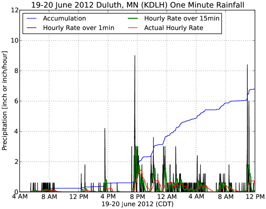
Duluth Flood Event
23 Jun 2012 09:21 AMA significant flood event impacted areas in and around Duluth, Minnesota this past week due to heavy rainfall over a multi-day period. The feature chart presents the one-minute interval precipitation observations from the Duluth ASOS sensor. Total precipitation for this event was nearly seven inches at this site. This rainfall caused record river heights in the area and significant damage.
Voting:
Good: 71
Bad: 14
Tags: flood

Prolonged Flood Event
01 Sep 2011 05:52 AMOne of the big stories this year has been the flooding along the Missouri River. The featured chart presents the river stage observation from one of the automated sites near Sioux City. The river was in moderate flood stage for over 2 months! Among other things, this did a tremendous amount of damage to some the highways and interstates in the area which will require complete reconstruction.
Voting:
Good: 20
Bad: 3
Tags: 2011 flood

Not quite 1993 for the Squaw
12 Aug 2010 07:01 AMSquaw Creek in Ames approached record levels seen back in 1993 yesterday, but came up a few inches short (18.13" versus 18.5"). The Squaw is the western river in Ames and affects the Iowa State University Campus. Many of you probably saw the water in Hilton Coliseum, that was from the Squaw. The featured image presents a comparison between 1993 and 2010 for the river gauge near Lincoln Way in Ames. With heavy rainfall expected on Friday night, it will be interesting to see how the secondary bump in river flow compares with 1993.
Voting:
Good: 35
Bad: 2
Tags: flood squaw

Surpassing 1993
11 Aug 2010 07:13 AMThe featured graph is from the National Weather Service website showing the forecasted crest for the Squaw Creek in Ames to exceed levels seen in 1993!
Voting:
Good: 32
Bad: 12
Tags: flood

About three times average
16 Jun 2010 06:05 AMSouthern Iowa has certainly seen the worst of the heavy rainfall so far this summer. The featured chart is for the Lamoni ASOS since the first of May showing a total of over 18 inches of rain while the average accumulation for the period is only 6 some inches. Could a completely dry day finally be in store today? Regardless, more chances of thunderstorms, some of them severe, are back in the forecast for Thursday and Friday.
Voting:
Good: 29
Bad: 6
Tags: flood

Plenty of supply
26 Feb 2010 06:17 AMThe featured map displays NOAA modeled snow water equivalent (the depth of liquid water present in the snow pack) for the Des Moines River Basin (red outline) upstream of Saylorville Lake. A crude GIS calculation indicates that there is enough frozen water in the basin to fill Saylorville Lake 2.5 times! Of course, not all of this water will make it downstream into the reservoir, but we will have to be fairly lucky to melt all of this snow without significant flooding. The worst case scenario would be for a heavy rainfall event on top of this extensive snow pack. There is about 550 billion gallons of frozen supply upstream of a reservoir that holds 221 billion gallons.
Voting:
Good: 66
Bad: 23
Tags: flood swe

Ames Flooding
02 Jun 2008 07:33 AMThe featured hydrograph was taken from the NWS website showing the South Skunk river coming within a foot of setting a record stage. The current river stage is back below flooding levels, but more heavy rainfall is expected this week. Soils are currently saturated and rainfall will quickly runoff causing flooding once again.
Voting:
Good: 23
Bad: 5
Tags: flood