Past IEM Features tagged: dec152021

December 15th Outlier
18 Dec 2023 05:30 AMThis past Friday was the three year anniversary of one of the most anomalous weather events on record for Iowa. 15 December 2021 featured record setting December warmth followed by a "serial derecho" that extreme winds and 60+ tornadoes to the state. A number of IEM Daily Features covered many of the unique aspects of this event. Today's featured chart presents the largest number of calendar day tornado warnings issued for Iowa during the December through February period. Again, just a remarkably anomalous event with nothing even close to being a comparable.
Voting:
Good: 16
Bad: 1
Tags: dec152021
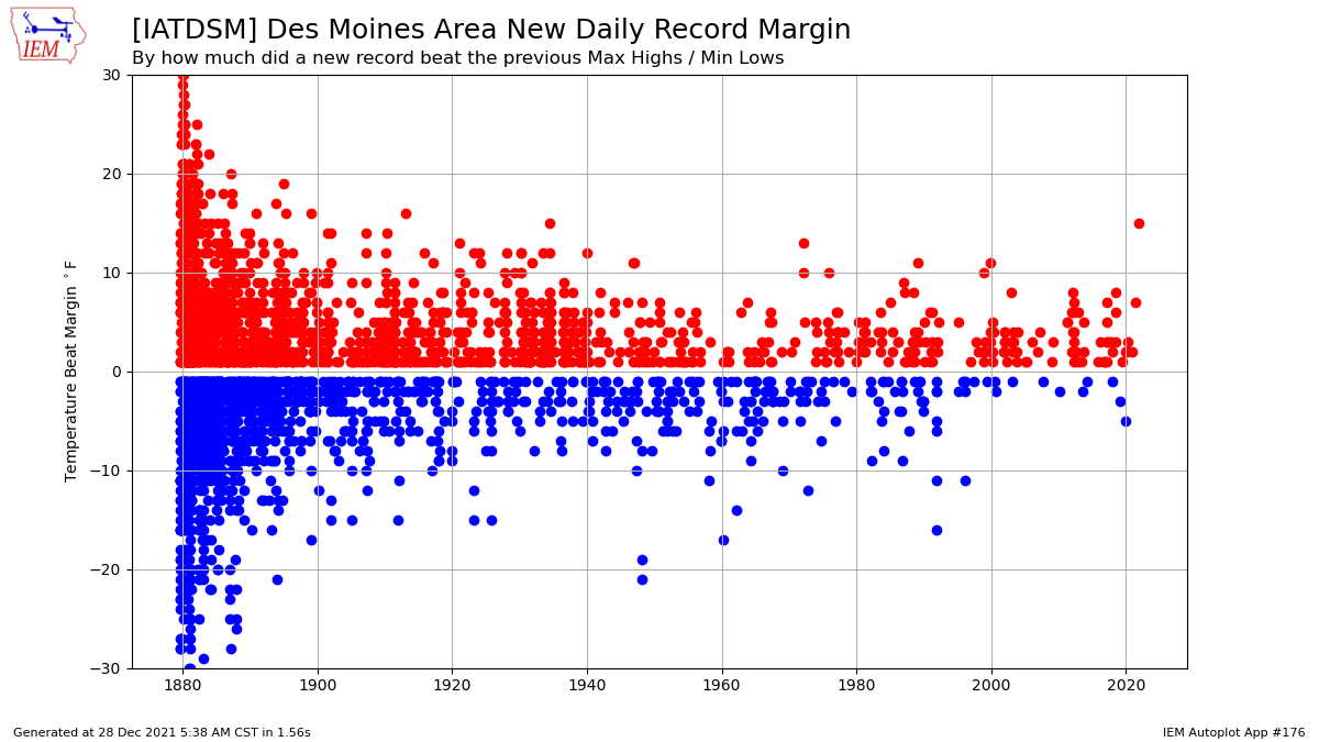
Record Smashing
28 Dec 2021 05:39 AMWhen you set an all time December record high temperature, like Des Moines did back on the 15th, of course the daily high record for that day is beat as well. The remarkable aspect of the daily record high temperature beat was the amount greater than the previous record for the date. The featured chart presents the dates over the period of record for Des Moines where a new daily max high or daily min low were established. The previous record was 59 degrees with the new record being 74, so a beat of 15 degrees! The chart indicates this being the largest beat since another 15 degree beat back on 30 May 1934!
Voting:
Good: 15
Bad: 0
Tags: dec152021
New December Record
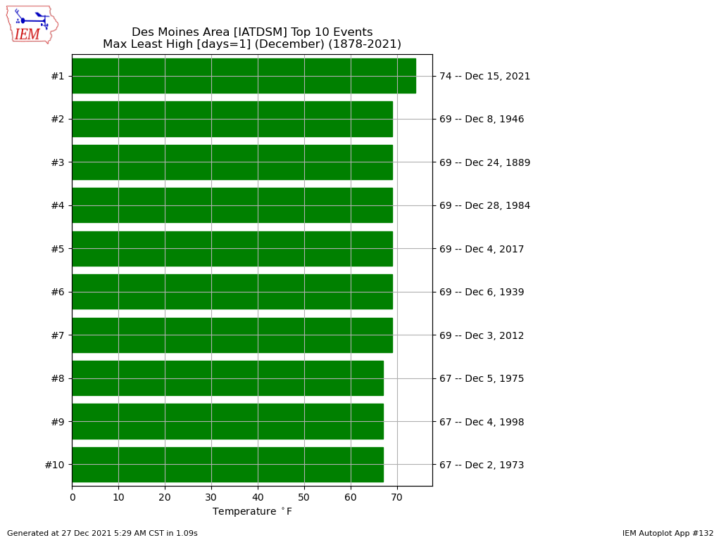
27 Dec 2021 05:36 AMTwelve days after the epic weather events of 15 December and there is still content to feature! The featured chart presents the greatest high temperatures as computed by hourly archives available from the Des Moines Airport during the month of December. The high of 74 is a significant step up from the next warmest value at 69 degrees. Many other sites in the state also established new record high temperatures for the month of December. The overall Iowa statewide record high for the month was likely established as well, but some more time is needed to make that official.
Voting:
Good: 7
Bad: 0
Tags: dec152021

December Tornado Warnings
23 Dec 2021 06:20 AMIt has been over a week now since the epic events of two Wednesday's ago. The National Weather Service is now up to 42 tornadoes within Iowa that day, which is the largest single day outbreak on record. This event just continues to boggle the mind that this happened during December! The featured chart presents the number of Tornado Warnings issued within Iowa by month since 1986. Again, just crazy to see 36 warnings happening this month and then comparing that to just one total for all previous Decembers and for that total to tie the previous monthly maximum this year during July. May we live in interesting times!
Voting:
Good: 15
Bad: 3
Tags: dec152021
December Derecho
21 Dec 2021 05:34 AMIt is absolutely crazy that Iowa was hit by another Derecho and this time during the month of December. The Storm Prediction Center, which tracks Derecho occurrences, is currently calling the storm system that hit Iowa last Wednesday a "Serial Derecho". The serial portion of the name gets into some meteorology nuance of the event, but the derecho portion of having a long track and long time duration of continuous high wind speeds associated with convection applies. The featured movie presents the combination of NEXRAD mosaic, NWS Severe Thunderstorm / Tornado Warnings, and any thunderstorm related severe wind gusts from Local Storm Reports (LSR)s. The bottom panel attempts to illustrate how continuous in time the reports were as each report is given by a bar of 5 minutes width. You'll notice over ten hours of overlapping bars, which indicates no breaks in the reports.
Voting:
Good: 23
Bad: 2
Tags: dec152021
Extreme Storm Motion
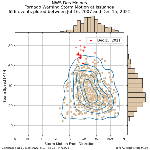
20 Dec 2021 05:35 AMContinuing the theme of highlighting the exceptional weather last Wednesday, today's featured chart presents a climatology of storm motion as specified within NWS Tornado Warnings issued by the Des Moines office. Since 2007, these warnings contain an analyzed storm motion with a travel direction and speed. The featured chart shows all these warning combinations with those from the last event highlighted by a red cross. So while the direction of travel, from approximately the southwest and thus in the northeast direction, was typical for tornado producing storms, the storm speed was anything but typical. Only one other warning on record is shown within the cluster of warnings happening last Wednesday in the 75 to 85 MPH range. Just incredible to see these extreme storm motions with numerous storms that produced confirmed tornadoes and let alone this happening during December!
Voting:
Good: 11
Bad: 1
Tags: dec152021
Nearly covered the state
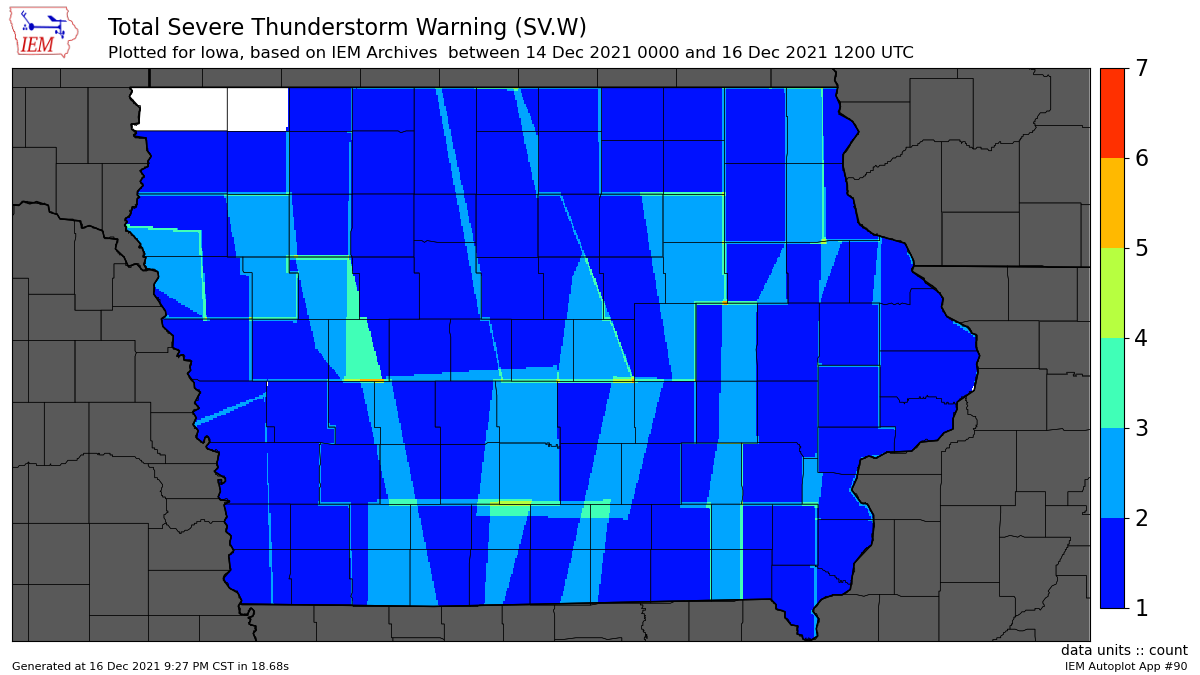
17 Dec 2021 05:31 AMHaving either a Severe Thunderstorm or Tornado Warning during the month of December is very rare. Another way to show how anomalous the events on Wednesday were, the featured map presents a heatmap of polygon Severe Thunderstorm Warnings issued for the event by the NWS. Outside of the two far NW Iowa counties, the entire state was covered by at least one warning. This plot does not include the numerous Tornado Warnings issued as well. It continues to just blow the mind that the most active severe weather day this state saw this year happened during December! Unfortunately, there was a lot of damage associated with the extreme winds that prompted these warnings. Power remains out for thousands of folks with some expected to not regain power for a number of days to come yet.
Voting:
Good: 18
Bad: 1
Tags: dec152021
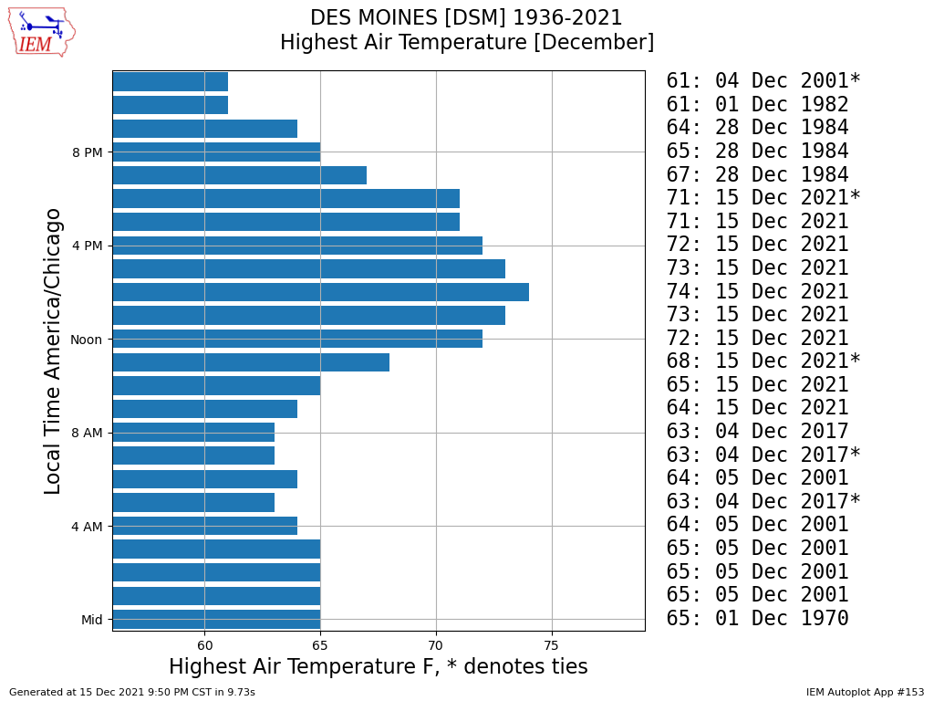
December Hourly Temp Records
16 Dec 2021 05:31 AMIt feels like it will take the rest of the year to cover all the wild events on 15 December with IEM Daily Features. First up is covering the extremely warm temperatures with most locations in the state setting new all-time record high temperatures for the month of December. While not an official statistic, the IEM computes hourly maximum values based on available data. The featured chart presents this for Des Moines and shows a number of records set mostly during the daylight hours along with the overall new high of 74 degrees shown. Just a mind blowing anomalous event and something that many folks will remember and compare with the 2020 Derecho.
Voting:
Good: 16
Bad: 0
Tags: dec152021
Epic 15 December 2021
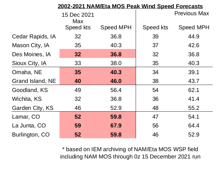
15 Dec 2021 12:04 AMAfter the Derecho of 10 August 2020 rewrote Iowa's weather history book last year and the generally quiet severe weather season this year, one maybe wondered if we could have escaped 2021 without any memorable events. That no longer appears to be the case with the date of 15 December 2021 likely to go down as very memorable. The weather forecast models and human forecasters are predicting extreme wind speeds that are difficult to find comparable events with over Iowa's recorded history. Many folks are wondering how this event will compare with the fresh-in-the-mind Derecho of last year. The two events are difficult to compare as their meteorology is quite different with a Derecho being the result of a strong thunderstorm complex and today's event being driven by larger scale forcing. Additionally, having it happen during December means that there is practically no vegetation over Iowa's agricultural landscape nor deciduous trees, so near surface wind speeds can be stronger due to reduced friction. For rough ballpark numbers, the Derecho produced 60-80 MPH sustained winds with higher gusts over periods around 30 minutes and less. Today's event will produce 35-50 MPH sustained with gusts in the 50-70 MPH range but over a multiple hour window of time this evening. The additional concerning threat today will come from any storms that form and their ability to produce significant tornadoes. Even having such a tornado threat during mid December is quite remarkable, but this is following a devastating tornado outbreak over the southeastern US last Friday. Even if these storms do not produce tornadoes, they will surely produce damaging wind gusts above and beyond what is being experienced without the thunderstorms present. The featured infographic displays a nuanced summary of forecast sustained wind speeds by a forecast system associated with the NAM model called NAM MOS. The IEM has an archive of this data since 2002 and a number of locations shown have a forecast value above anything previously on record. Oh, we have not even mentioned yet that today may be memorable for establishing new all-time December high temperatures and maximum dew point readings. The threats today are strong winds, storms with stronger winds / maybe tornadoes, and then even stronger winds overnight. Hunker down!
Voting:
Good: 35
Bad: 0
Tags: dec152021

Weather Model Fantasy Land?
08 Dec 2021 05:32 AMAfter an expected winter storm that will bring accumulating snowfall over northwestern Iowa later this week, a major temperature warm up is expected next week. Weather forecasters are already buzzing with how warm temperatures are predicted by models like the NWS Global Forecast System (GFS). The featured map is a forecast for *next* Wednesday afternoon with much of Iowa in the 65 to 75 degree range. If this would verify, it would represent a number of new month of December records for high temperature over Iowa! Of course, many consider maps like these "model fantasy land" as it is a 189 hour forecast!
Voting:
Good: 22
Bad: 1
Tags: dec152021