Past IEM Features tagged: blizzard

Blizzard Warning Frequencies
12 Jan 2024 05:30 AMOur epic week of winter weather ramps up today with much of the state under a Blizzard Warning. Falling snow and the snow from the earlier snow storm this week will be blown around thanks to very strong winds. With unofficial data back to 2007, the featured map presents the Blizzard Warning frequency by county. This is roughly an once per season event with the highest frequencies found over north central Iowa and lowest in far NE and SE Iowa. Iowa's landscapes explain most the variability found within this map. Blizzard conditions are easiest to achieve over mostly flat areas without much tree cover. This combination allows for more blowing snow, which helps to sustain prolonged conditions necessary to meet blizzard criterion (35+ MPH winds and less than a quarter mile visibility for three hours straight). The presence of hills and trees both work to reduce blowing snow and overall wind speeds.
Voting:
Good: 19
Bad: 1
Tags: blizzard

Dec 2022 Blizzard
24 Dec 2022 07:09 AMThe upfront caveat for today's featured plot is that verifying Blizzard Warnings with automated weather stations is difficult. The difficulties include stations that may struggle at observing low horizontal visibility and/or have urban sheltering from blowing snow. The criterion for Blizzard Warnings also requires at least three consecutive hours with winds of at least 35 MPH and visibility values at or below a quarter mile. The Blizzard Warning for Iowa has thankfully expired this morning, so the featured chart presents a look at five selected Iowa airport weather stations along with Buffalo, NY for a wild comparison. The dashed red line show the wind requirement and dashed blue line shows the visibility requirement. Areas shaded in gray are instantly meeting both those requirements and areas shaded in blue have meet the three hour requirement. The time duration of each plot matches the duration of the Blizzard Warning for that location, except Buffalo, which is still ongoing at the time of this feature posting. For Iowa, the situation Friday afternoon was clearly the worst for the event. The visibility requirement was more difficult to meet for this event vs the wind speed. Again, caveats here as blowing snow was much more significant in rural areas. And wow, what an ongoing event for Buffalo, which is experiencing an epic Lake Effect Blizzard.
Voting:
Good: 14
Bad: 3
Tags: blizzard

Days since last Blizzard Warning
18 Nov 2022 05:30 AMThe snow storms this week were handled by Winter Weather Advisory headlines by the National Weather Service. Their most severe headline for the winter season is the Blizzard Warning, but not every year sees such an intense situation. The featured map presents the number of days since the last Blizzard Warning per NWS Weather Forecast Office (WFO). Immediately and interestingly, you can see Hawaii at 348 days whereas most of the Iowa WFOs had 650 days and longer. The data is correct as there is some very high elevation land in Hawaii that sees intense winter storms. As an aside, the NWS recent announced that Hawaii would stop issuing Blizzard Warnings going forward as no humans live within the impacted areas.
Voting:
Good: 19
Bad: 1
Tags: blizzard

Blizzard Warning Frequency
04 Feb 2021 05:34 AMA Blizzard Warning is in effect for today into tomorrow for much of north central Iowa. Such warnings are issued when strong winds are combined with falling or blowing snow to reduce visibilities for at least three hours. The featured map displays the frequency of blizzard warnings per year by county since 2007 based on IEM unofficial data. If you know the land form regions of Iowa, the map nicely aligns as frequencies are the highest over the flattest and least tree covered areas of the Des Moines Lobe. Having terrain features and trees makes achieving blizzard conditions more difficult as near surface wind speeds are reduced and obstructions cut down on blowing snow. After the Blizzard rolls through, much colder air is set to arrive for the weekend along with bitter cold wind chills.
Voting:
Good: 14
Bad: 0
Tags: blizzard

Meeting Blizzard Criteria
27 Nov 2018 05:28 AMThe NWS issues a Blizzard Warning when falling and/or blowing snow combines with strong winds to create dangerously low visibility over at least a three hour period. The threshold for wind is frequent gusts over 30 knots and visibility is frequently less than a quarter mile. The featured chart looks at meeting that criteria based on automated airport weather stations that were under the Blizzard Warning. The three panels uses different methodologies to summarize the best (closest to meeting criteria) values based on wind speed and visibility. The first panel uses a strict requirement on all reported winds and visibility, the second panel takes the three hour average and the third panel uses the median value over the three hour period. Verifying blizzards with automated weather station data is difficult, but so is it for a human as we tend to not want to stay outside for three hour stretches in very bad winter weather.
Voting:
Good: 17
Bad: 1
Tags: blizzard

Was is a blizzard?
04 Feb 2016 05:35 AMThe formal definition of a blizzard by the American Meteorological Society (AMS) and National Weather Service (NWS) is somewhat vague. It requires frequent wind gust over 35 mph and frequent visibility reductions due to falling or blowing snow to less than a quarter mile over at least a 3 hour period. There are problematic parts of that definition including what 'frequent' means and how exactly such conditions can be observed reliably by automated equipment and humans, who would rather not be outside for 3 hour periods during bad weather! So was our recent storm a blizzard? The featured chart looks at the wind speed, visibility, and time components of the blizzard definition for Mason City for the recent event, an event from 2015 and a significant event from 2010. The chart assumes the visibility reduction is due to snow and not fog. The highlighted ares in gray are meeting the criteria and blue completely meet the criteria for a 3+ hour period. For the most recent storm, only a brief period was able to meet the criteria as wind speeds were not often above 35mph. So was the recent storm a blizzard for Mason City? It is difficult to say with automated data, I suspect many humans would say otherwise.
Voting:
Good: 22
Bad: 12
Abstain: 9
Tags: blizzard

Last Blizzard Watch
01 Feb 2016 05:35 AMMuch of Iowa is under a Blizzard Watch for an anticipated significant winter storm arriving this Monday evening. The featured map displays the last year each county in the state was under a Blizzard Watch since the start of the IEM archive back in 2005. Allamakee and Clayton counties are shown to not having a watch issued. Blizzard conditions are expected on Tuesday.
Voting:
Good: 24
Bad: 13
Abstain: 12
Tags: blizzard

Svr/Tor Warning during Blizzard Warning
22 Feb 2014 09:22 AMThe recent blizzard event on Thursday featured a somewhat rare combination of a forecast zone being under a blizzard warning and also having a severe thunderstorm warning active at the same time! The featured chart presents an IEM computation of the number of times this has happened since late 2005. This combination happens approximately once each year for some lucky location in the country.
Voting:
Good: 31
Bad: 6
Abstain: 3
Tags: nws blizzard
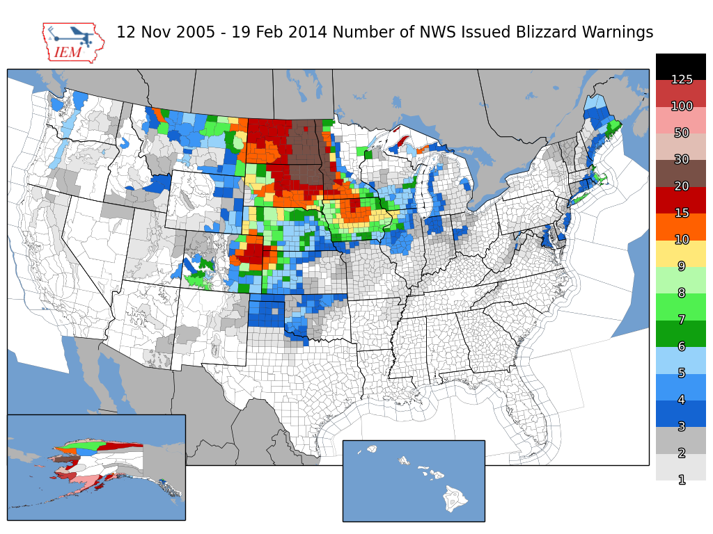
Blizzard Warnings
20 Feb 2014 05:16 AMBlizzard warnings are active for today as a major winter storm strengthens over the plains. The featured map presents the number of NWS issued Blizzard Warnings since late 2005. You'll want to click the image for a better view. Blizzard conditions are not trivial to produce as the combination of near zero visibility needs to coincide with snow and very strong winds. The map shows the favored area for these conditions over very flat and mostly tree- less Upper Midwest. The gradient is clear in Minnesota as trees slow surface winds down and help keep blowing snow in check.
Voting:
Good: 47
Bad: 6
Abstain: 5
Tags: nws blizzard

Where there was snow, there was trouble
28 Jan 2014 05:43 AMThe featured map shows the combination of Terra MODIS true-color satellite on Monday, outline of the blizzard warning on Sunday, and roads that were in "travel not advised" status for the recent storm. While the entire state experienced strong winds and bitter cold, areas that actually had snow on the ground experienced the blizzard conditions. Some counties in the blizzard warning had zero travel concerns in the southwestern portion of the county, while the northeastern portion had blizzard conditions. The entire state is once again below zero with very cold wind chills.
Voting:
Good: 37
Bad: 3
Abstain: 6
Tags: blizzard 2014

Blizzard Warning Climatology
17 Mar 2013 03:55 PMBlizzard Warnings are in effect over far northern Iowa for Monday thanks to a quick moving storm system that will dump snow and then blow it around a bunch. Are blizzard warnings common as we are mere days from spring? The featured chart attempts to provide a climatology of blizzard warnings in the continental US by week of the year. The unit is the combination of a single NWS weather forecast office issuing a blizzard warning for a given week of the year. For example, the peak value in late December represents, on average, seven NWS offices issuing at least one blizzard warning per year. The chart shows a remarkable drop during the heart of winter in January. The reason for this drop is that blizzard systems are driven by large temperature gradients and amble supplies of moisture, both of which are somewhat limited in January as most the country is at its coldest.
Voting:
Good: 7
Bad: 2
Tags: blizzard nws

Recent Blizzards
26 Dec 2012 05:48 AMThe featured chart presents a time series of observed visibility and wind gust from the Des Moines Airport for five recent blizzard events. These events are when Polk County was under a Blizzard Warning. The definition of a blizzard is somewhat vague in that visibility should be frequently reduced to a quarter mile or less and wind gusts be frequently in excess of 35 mph for at least a three hour period. The highlighted sections in the chart denote the periods at quarter mile visibility and 35+ mph winds. For last week's blizzard (top chart), the visibility was only briefly at a quarter mile. Automated weather sensors do not do a good job reporting these low visibilities during snow and blowing snow conditions, so blizzards tend to be verified by people like police and snow plow drivers who are out in the storm and can attest to the frequent poor visibilities and strong winds over a three hour period.
Voting:
Good: 49
Bad: 6
Tags: blizzard

No Blizzard Warnings, yet
28 Feb 2012 05:53 AMA major winter storm is organizing this morning with the worst conditions expected to stay just to our north where blizzard warnings are in effect. Unlike the past two winters where each county in Iowa got at least one blizzard warning issued for the season, this winter has seen none thus far.
Voting:
Good: 17
Bad: 4
Tags: blizzard

Snow Storm #12
03 Feb 2011 05:50 AMThe featured map presents an IEM produced analysis of snowfall reports from the epic blizzard. Snow totals over a foot stretched from Oklahoma to Chicago to the east coast. The heaviest totals in Iowa were around 18 inches. The presented map does have one caveat that some of the snowfall from the first storm over the weekend was included in the snowfall reports used to make this map. The departure of the storm has left us bitterly cold air and wind chills well below zero.
Voting:
Good: 26
Bad: 5
Tags: winter1011 blizzard

Blizzard Criteria
12 Dec 2010 12:32 PMWith the entire state under a blizzard warning during portions of Saturday and Sunday, one may wonder if the entire state experienced blizzard conditions. The term blizzard is typically applied to a period of at least three hours where visibilities are less than 1/4 mile due to snow or blowing snow along with wind speeds at or above 35 mph. People typically do not stand outside during strong winter storms, so it is hard for them to meet the three hour requirement and only report an instantaneous blizzard. Automated weather equipment struggles at low visibilities... The featured chart shows a comparison between reported three hour visibilities and wind speeds. Both plots contain two sets of data. The 'best wind' dataset includes the variable combination when winds were the strongest. The 'best vis' contains the observations when visibilities were the lowest. The x-axis is shown in log format, so to visually see smaller values. The left hand chart uses max/min values over the three hours, while the right hand chart uses simple averages (helping out the wind criteria). Even using the more lenient method, only ~20% of the sites in Iowa hit blizzard criteria in this qualitative form. For those that were outside, they probably considered the weather blizzard like.
Update: NWS Directive has the blizzard warning criteria as "Sustained wind or frequent gusts greater than or equal to 35mph accompanied by falling and/or blowing snow, frequently reducing visibility to less than 1/4 mile for three hours or more." (but no definition of what "frequently" means)
Voting:
Good: 39
Bad: 10
Tags: winter1011 blizzard nws

Blizzard Warning for the entire state
11 Dec 2010 07:28 PMA powerful winter storm system is winding up this Saturday evening over Iowa with the entire state now under a blizzard warning as shown by the featured map. The counties shown in pink also have local civil emergencies warning motorists to stay home as no help will be available if they get stuck. Winds have been extreme with gusts over western Iowa topping 60 mph. In the wake of this storm system, very cold air is set to arrive on Sunday and Monday with highs hopefully in the single digits.
Voting:
Good: 45
Bad: 6
Tags: winter1011 blizzard

Snow, wind, and roads
11 Dec 2009 06:10 AMThe featured chart looks back at the recent blizzard experience for the state and compares IEM estimates of State Patrol road travel advisories and closures with statewide estimates of mean wind speed and NEXRAD reflectivity coverage. The chart shows that the peak in snowfall coverage came before the maximum wind intensities. You can also see a very clear relationship between the improvement of road condition with the decrease in wind speed on Wednesday evening (Dec 9th).
Voting:
Good: 53
Bad: 14
Tags: blizzard road nexrad
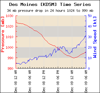
34 mb drop!
09 Dec 2009 06:43 AMAn epic winter storm has most of Iowa shut down this Wednesday morning with snowfall amounts approaching a foot and a half in areas. The big story now is the blowing snow thanks to strong winds blowing over 30 mph sustained. These winds are due to a tremendous pressure gradient over the state. The featured image shows the pressure drop yesterday for the Des Moines ASOS at 34 millibar in a 24 hour period. This rapid change, perhaps unprecedented, in pressure will help keep winds strong today and roads in Iowa impassable.
Voting:
Good: 86
Bad: 8
Tags: blizzard bomb pressure

Snow and wind coming
12 Jan 2009 06:10 AMToday's feature is provided by BUFKIT Warehouse proprietor Chris Karstens.
The featured plot shows the NAM forecast of hourly qpf (in.) and mean mixed layer wind speeds (mph) for Slater, IA, initialized 6pm CST Sunday. A good shot of snow looks to be on tap this morning, with winds picking up later in the afternoon and evening, gusting near 40 mph, making for blizzard conditions. The National Weather Service has issued blizzard warnings for the expected impact of this morning and this past weekend's snow blowing around leading to whiteout conditions.
Voting:
Good: 23
Bad: 8
Tags: bufkit blizzard