Past IEM Features tagged: 2015

Late for a Tornado Warning
28 Dec 2015 05:36 AMLast Wednesday, the 23rd, the Davenport NWS Office issued a Tornado Warning that included portions of Scott and Clinton Counties in Iowa. This is the only December Tornado Warning for Iowa found in the IEM archives that date back since 1986. It is believed that prior to 1986, a few tornado warnings were issued in December for Iowa. Regardless, the featured chart displays the period between the first and last Tornado Warning issued by the Davenport Office. The average last date for a Tornado Warning is the middle of August!
Voting:
Good: 23
Bad: 13
Abstain: 8
Tags: warnings 2015

Epic December Rainfall
14 Dec 2015 05:40 AMRainfall continues this Monday morning and the mind blowing totals continue to pile up over Iowa. The featured map displays just the totals from Saturday and Sunday with much of the state shown over an inch and large stripe of the state in the 2-3+ inch range. This may likely go down in the record books as the heaviest precipitation event to hit the state during the winter season!
Voting:
Good: 36
Bad: 7
Abstain: 11
Tags: 2015

Few Recent Cold Days
10 Dec 2015 05:37 AMTemperatures again warmed very nicely into the lower 50s for much of the state on Wednesday, which made for yet another day above average this fall. The featured chart displays the daily high and low temperatures for Des Moines along with the climatology and departure from average expressed in units of standard deviation. Since 1 September, only a few days have been colder than negative one standard deviation from average! Even warmer weather is expected today!
Voting:
Good: 17
Bad: 12
Abstain: 7
Tags: 2015
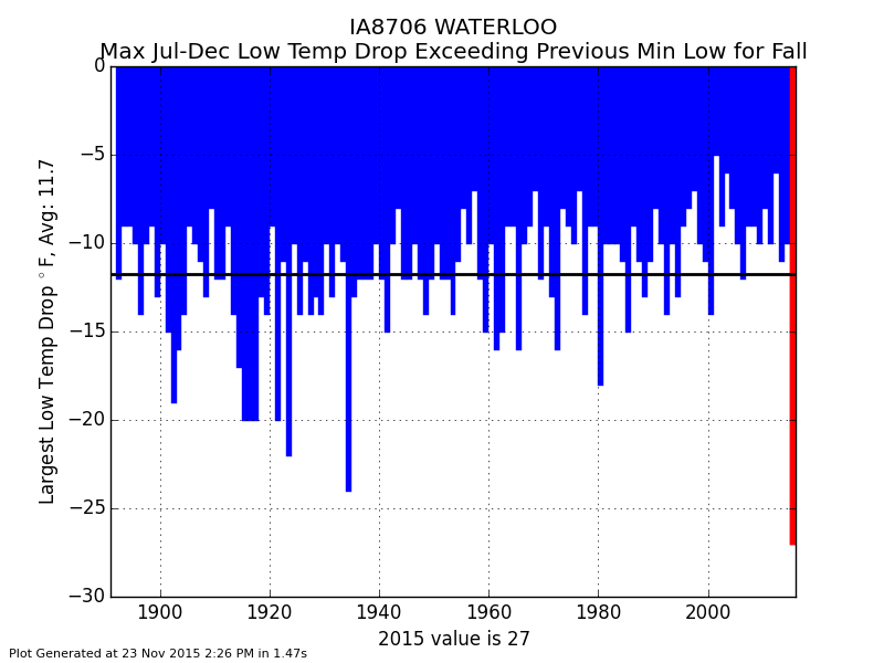
Largest Drop
24 Nov 2015 05:36 AMOn 17 October, the Waterloo Airport had its coldest low temperature to date of 22 degrees. That remained the coldest temperature until -5 was reported Saturday morning. That 27 degree difference in the coldest low temperature to date was the largest on record for the site! The yearly largest low temperature to date drop is presented in the featured chart for Waterloo. The conditions this year created a near perfect situation for this large of a change to occur. Up until our recent snowfall, overnight low temperatures have been warm for the season. Our first snowfall created a deep and fresh snow pack that allowed for temperatures to plummet quickly one night as the skies cleared and winds were calm.
Voting:
Good: 17
Bad: 3
Abstain: 2
Tags: 2015

Few Hot Days since March
07 Jul 2015 05:40 AMVery warm weather has been difficult to come by this year. The featured chart displays the daily high temperature departures from long term average for Ames. Since March, we have only seen a few days with the high temperature 10 plus degrees above average. That looks to continue for the remainder of this week with highs only in the 70s.
Voting:
Good: 12
Bad: 6
Abstain: 3
Tags: 2015

Few widespread rain events
07 Apr 2015 05:40 AMEven using a modest threshold of a quarter inch of precipitation over seven days, the featured chart shows very few widespread events over Iowa so far this year. The snowfall of early February is about all there is to show for big precipitation events this year. There is hope that this is about to change this week as a large storm system brings the best rainfall chances we have seen this year. Severe weather also looks likely, but the worst weather will be to our south.
Voting:
Good: 15
Bad: 12
Abstain: 10
Tags: 2015

Maximum Dew Point
02 Apr 2015 05:43 AMThe featured table displays the January thru March maximum dew point as computed over the hourly reported observations. The maximum values this year are some of the lowest on record for sites in Iowa. Des Moines maximum of only 45 degrees was just one degree higher than the lowest values of 44 back in 1956 and 2001. The moist air from the Gulf of Mexico has struggled to reach Iowa this year and that is a big reason for our paltry precipitation totals so far. A cold front is currently sweeping the state and some locations have picked up 0.5 to 1 inch of precipitation.
Voting:
Good: 25
Bad: 10
Abstain: 9
Tags: 2015

Quiet Start to 2015
19 Mar 2015 05:42 AMThe featured chart presents the year to date accumulated total of Severe Thunderstorm and Tornado Warnings issued by United States NWS Offices. Not only is the total for 2015 the lowest since at least 2003, it is not even close to any other year! The next closest year of 2004 is about four times greater than this year! Of course, a very active severe weather week could make up these differences, but such a week does not appear to be any time soon. Eventually the warm and muggy Gulf of Mexico air will surge northward and provide a needed ingredient for severe weather. This will also provide some needed rain as our current stretch of weather has been very dry as well.
Voting:
Good: 18
Bad: 4
Abstain: 4
Tags: 2015 severe