Past Features
This page lists out the IEM Daily Features for a month at a time. Features have been posted on most days since February 2002. List all feature titles.
Wed Dec 01, 2021

December 60s
01 Dec 2021 05:35 AM
Welcome to December and very welcome is a mild start to the month with 60 degrees in the forecast for today and again tomorrow. The featured chart presents the daily frequency during December of reaching at least 60 degrees for Des Moines. For four days during the month, such a warm temperature would set a record high and the overall average is just having one day every two years. The numbers shown above the bars are the actual number of years having such a warm temperature. The eternal pessimist wonders when we will have to "pay for" such great weather, but until then, enjoy it!
Voting: Good - 14 Bad - 1
Generate This Chart on Website
Thu Dec 02, 2021
90% of Sites
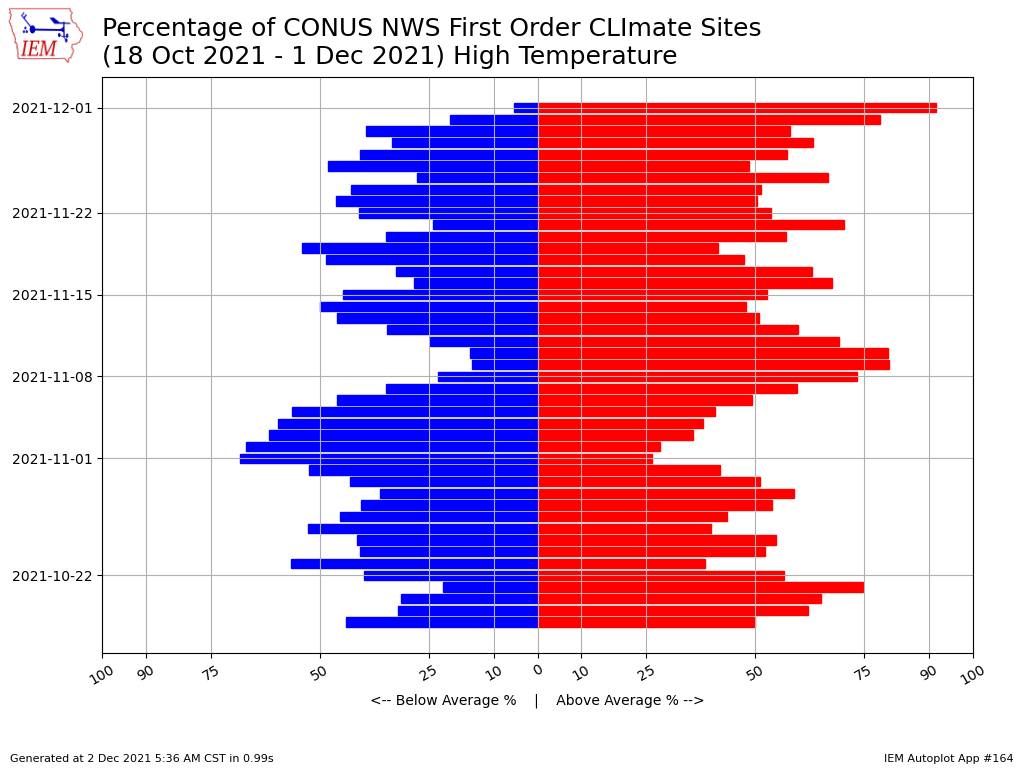
02 Dec 2021 05:43 AM
Above average temperatures have a strong grip on the conterminous United States. The featured chart presents the percentage of NWS "CLI"mate reporting sites that had an above average high temperature for each day since mid October. There is no spatial weighting to this plot, so the percentages should not be conflated to an areal coverage. The bulk statistic shows over 90% of the sites reporting an above average high yesterday! There is not much to be seen for dominate cold with only early November shown solidly above 50%. The forecast today has more 60s in the state with cooler weather to follow, so please enjoy this while it lasts!
Voting: Good - 13 Bad - 1
Generate This Chart on Website
Fri Dec 03, 2021
850 Temps
03 Dec 2021 05:20 AM
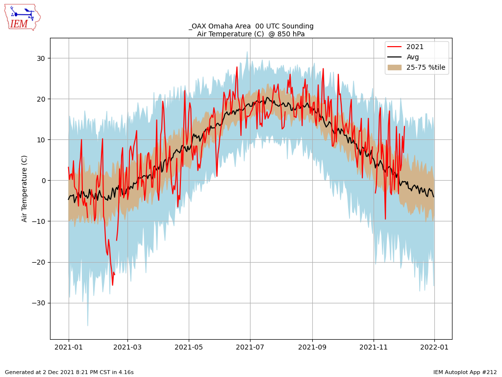
Twice a day, the NWS directly samples temperature, wind, pressure, and humidity of the troposphere by launching weather balloons. These instruments take observations at mandatory pressure levels (as well as others) to allow for map analyses to be made using all available balloon launches. One of these mandatory levels is at 850 hPa (millibar), which is a handful of thousands of feet above the ground here in the plains. The featured chart presents the time series of 850 hPa temperature (given in Centigrade) from the Omaha sounding site for the evening launch. The red line represents the time series of observations this year with the shaded areas showing the climatology based on long term data from the area. It stands to reason that with record warm temperatures at the surface, that the air aloft is also very warm for this time of year. Indeed, recent reports are shown at the top of the historical range. Since the 850 hPa level is relatively close to the surface, it correlates well with the air temperatures we humans feel. As you go higher in the atmosphere, record warmth near the surface often leads to record cold temperatures aloft at a given pressure level due to the increased thicknesses pushing a pressure level to higher altitudes and thus colder temperatures.
Voting: Good - 15 Bad - 1
Generate This Chart on Website
03 Dec 2021 05:20 AM
Twice a day, the NWS directly samples temperature, wind, pressure, and humidity of the troposphere by launching weather balloons. These instruments take observations at mandatory pressure levels (as well as others) to allow for map analyses to be made using all available balloon launches. One of these mandatory levels is at 850 hPa (millibar), which is a handful of thousands of feet above the ground here in the plains. The featured chart presents the time series of 850 hPa temperature (given in Centigrade) from the Omaha sounding site for the evening launch. The red line represents the time series of observations this year with the shaded areas showing the climatology based on long term data from the area. It stands to reason that with record warm temperatures at the surface, that the air aloft is also very warm for this time of year. Indeed, recent reports are shown at the top of the historical range. Since the 850 hPa level is relatively close to the surface, it correlates well with the air temperatures we humans feel. As you go higher in the atmosphere, record warmth near the surface often leads to record cold temperatures aloft at a given pressure level due to the increased thicknesses pushing a pressure level to higher altitudes and thus colder temperatures.
Voting: Good - 15 Bad - 1
Generate This Chart on Website
Mon Dec 06, 2021

Windy Sunday Night
06 Dec 2021 05:37 AM
Winds were gusty Sunday afternoon and evening with the featured map presenting peak wind gust reports from the Iowa airport weather stations. A number of sites are shown having gusts over 50 MPH. A frontal passage was to blame and has also ushered a very cold air mass into the state with the coldest high temperatures to date for the season expected today. Temperatures will rebound this week and next week is looking rather warm again.
Voting: Good - 13 Bad - 0
Generate This Chart on Website
Tue Dec 07, 2021
Recent Low Temp Departures
07 Dec 2021 05:43 AM
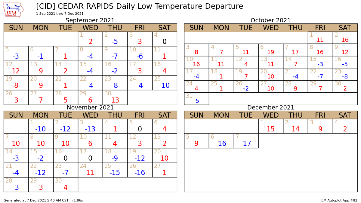
Chilly temperatures were present over Iowa on Monday with afternoon temperatures below freezing for most of the state. Even without snow cover, overnight temperatures really plummeted to with low temperatures on both yesterday and today well below average. The featured calendar plot presents daily low temperature departures for Cedar Rapids over the past two months. This morning's low departure is the most negative to be seen over this period. Temperatures are forecast to moderate this week with warm weather for this time of year expected next week as well.
Voting: Good - 10 Bad - 0
Generate This Chart on Website
07 Dec 2021 05:43 AM
Chilly temperatures were present over Iowa on Monday with afternoon temperatures below freezing for most of the state. Even without snow cover, overnight temperatures really plummeted to with low temperatures on both yesterday and today well below average. The featured calendar plot presents daily low temperature departures for Cedar Rapids over the past two months. This morning's low departure is the most negative to be seen over this period. Temperatures are forecast to moderate this week with warm weather for this time of year expected next week as well.
Voting: Good - 10 Bad - 0
Generate This Chart on Website
Wed Dec 08, 2021

Weather Model Fantasy Land?
08 Dec 2021 05:32 AM
After an expected winter storm that will bring accumulating snowfall over northwestern Iowa later this week, a major temperature warm up is expected next week. Weather forecasters are already buzzing with how warm temperatures are predicted by models like the NWS Global Forecast System (GFS). The featured map is a forecast for *next* Wednesday afternoon with much of Iowa in the 65 to 75 degree range. If this would verify, it would represent a number of new month of December records for high temperature over Iowa! Of course, many consider maps like these "model fantasy land" as it is a 189 hour forecast!
Voting: Good - 22 Bad - 1
Tags: dec152021
Thu Dec 09, 2021

Soil Temp Response
09 Dec 2021 05:34 AM
During the transition seasons as warm and cold air masses battle it out, it is fun to check in on soil temperatures with depth as their response is often interesting. The featured chart presents soil temperatures since 20 November from the ISU Horticulture Farm near Ames showing depths of 4, 12, 24, and 50 inches. Within the soil, the proximity to the ground/air interface (read surface) is important as it takes time for heating from sunshine or warm air masses to penetrate. The diurnal response of the four inch depth value is much more amplified than that of twelve inches. The response is even slower and more muted at deeper depths, but the periods of warming shown at four inches eventually work their way to lower depths! So while the overall trend at the deeper depths is for cooling this time of year, the warm periods above do create bumps along the down-glide.
Voting: Good - 11 Bad - 0
Generate This Chart on Website
Fri Dec 10, 2021
First Big Snowfall of Season
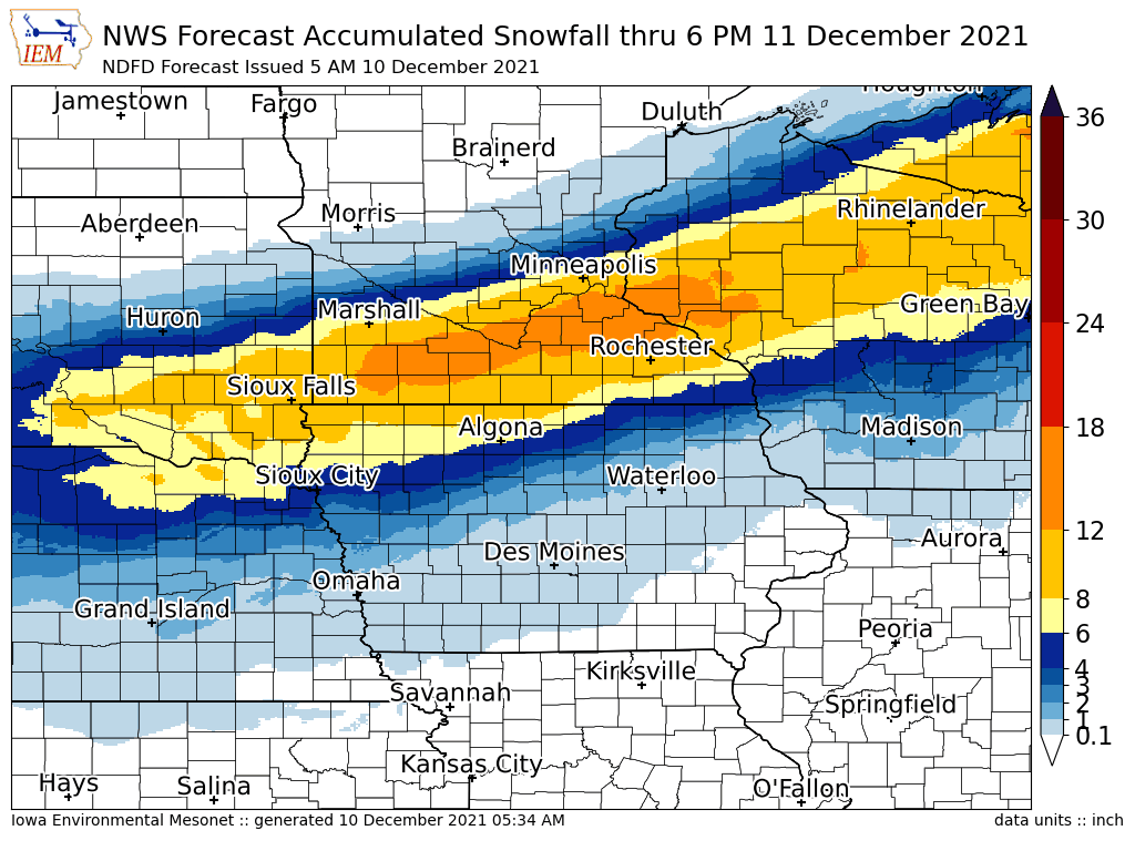
10 Dec 2021 05:35 AM
Our first major winter storm of the season is finally at hand with the featured map presenting the latest NWS snowfall forecast issued Friday morning. The heaviest totals approaching a foot are found over southern Minnesota and into Wisconsin. There will be a severe weather side to this major storm as well off to Iowa's south and east. The IEM is again producing maps presenting NWS and CoCoRaHS snowfall reports, so be sure to check back later today to see how much is fallen and then for an analysis map once the snow stops. The first storm of the season tends to be dangerous as drivers need reminded of how treacherous winter driving is.
Voting: Good - 19 Bad - 0
Sun Dec 12, 2021
'21-'22 Winter Storm #1
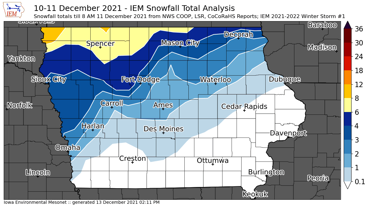
12 Dec 2021 08:05 AM
After a lengthy wait, the first significant snow producing storm of the season is now in the books. The warm side of the storm system produced a number of deadly tornadoes, whilst the cold side dumped heavy snowfall over places like southern Minnesota. Snowfall totals over Iowa were maximized over far northwestern Iowa as shown by the featured map. It presents the combination of NWS COOP, Local Storm Reports, and CoCoRaHS reports. The forecast focus now turns to a dramatic warm up expected mid week with a shot taken at new all time December high temperatures!
Voting: Good - 16 Bad - 0
Tags: winter2122
Mon Dec 13, 2021

December Monthly Record
13 Dec 2021 03:10 PM
Last week, the IEM daily feature showed a eight day forecast from a model predicting record high temperatures for the month of December on Wednesday. That forecast is appears to be panning out with official NWS forecasts now above all time record highs for the month for places like Des Moines and Ames. The featured chart presents IEM computed monthly record highs for Ames. The present forecast is 70 degrees, which would top the 68 degrees shown on the chart. Similarly, Des Moines forecast is 70 degrees which would top its record of 69 degrees for the month. While the temperatures will feel amazing, very strong and dangerous wind gusts are also forecast for later in the day and overnight on Wednesday into Thursday. There will also be a threat of severe storms as well. The present hope is that we will at least avoid a tornado outbreak on the scale of what happened last week over states near and including Kentucky, but ingredients for such an event will sadly be in place again over/near Iowa this time.
Voting: Good - 5 Bad - 0
Generate This Chart on Website
Tue Dec 14, 2021
High Wind Watch
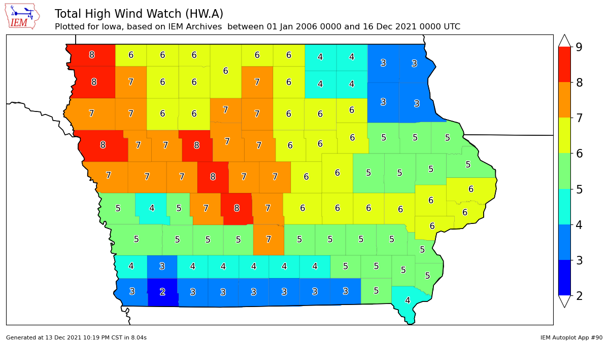
14 Dec 2021 05:34 AM
The upcoming wind storm along with any thunderstorms continue to be of top concern among weather forecasters for Wednesday into Thursday morning. The NWS issued a somewhat rare High Wind Watch for much of Iowa. The featured chart presents the number of such events with data back to 2006. For far southern and northeastern Iowa (both currently under the watch), there's very few other event during this period. Other portions of the state are necessarily not all that more frequent as this alert type is reserved for the most extreme of events. Any storms that are able to form will likely only increase the wind speeds as such storms typically transport higher velocity air aloft to the surface. While very strong to damaging winds seem to be a given at this point, the tornado threat remains less certain but will need to be closely watched. Storm motion will be very fast and these storms will come during the night time.
Voting: Good - 21 Bad - 0
Generate This Chart on Website
Wed Dec 15, 2021
Epic 15 December 2021
15 Dec 2021 12:04 AM
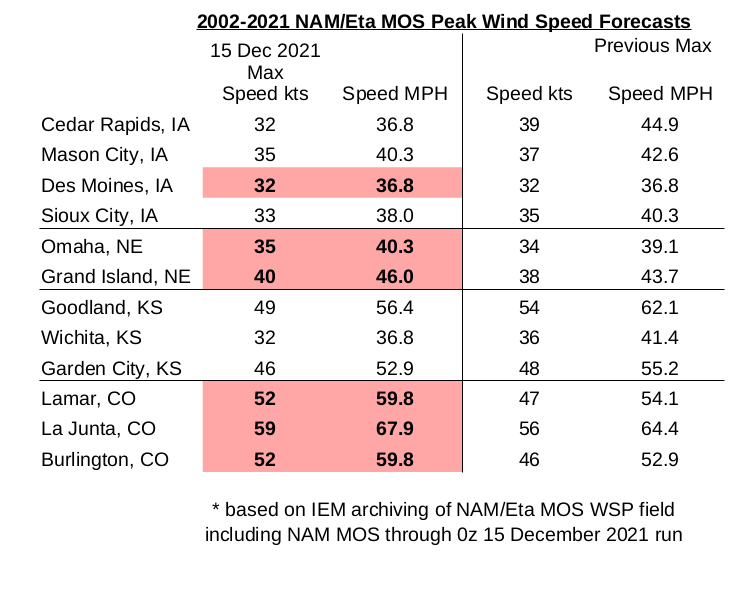
After the Derecho of 10 August 2020 rewrote Iowa's weather history book last year and the generally quiet severe weather season this year, one maybe wondered if we could have escaped 2021 without any memorable events. That no longer appears to be the case with the date of 15 December 2021 likely to go down as very memorable. The weather forecast models and human forecasters are predicting extreme wind speeds that are difficult to find comparable events with over Iowa's recorded history. Many folks are wondering how this event will compare with the fresh-in-the-mind Derecho of last year. The two events are difficult to compare as their meteorology is quite different with a Derecho being the result of a strong thunderstorm complex and today's event being driven by larger scale forcing. Additionally, having it happen during December means that there is practically no vegetation over Iowa's agricultural landscape nor deciduous trees, so near surface wind speeds can be stronger due to reduced friction. For rough ballpark numbers, the Derecho produced 60-80 MPH sustained winds with higher gusts over periods around 30 minutes and less. Today's event will produce 35-50 MPH sustained with gusts in the 50-70 MPH range but over a multiple hour window of time this evening. The additional concerning threat today will come from any storms that form and their ability to produce significant tornadoes. Even having such a tornado threat during mid December is quite remarkable, but this is following a devastating tornado outbreak over the southeastern US last Friday. Even if these storms do not produce tornadoes, they will surely produce damaging wind gusts above and beyond what is being experienced without the thunderstorms present. The featured infographic displays a nuanced summary of forecast sustained wind speeds by a forecast system associated with the NAM model called NAM MOS. The IEM has an archive of this data since 2002 and a number of locations shown have a forecast value above anything previously on record. Oh, we have not even mentioned yet that today may be memorable for establishing new all-time December high temperatures and maximum dew point readings. The threats today are strong winds, storms with stronger winds / maybe tornadoes, and then even stronger winds overnight. Hunker down!
Voting: Good - 35 Bad - 0
Tags: dec152021
15 Dec 2021 12:04 AM
After the Derecho of 10 August 2020 rewrote Iowa's weather history book last year and the generally quiet severe weather season this year, one maybe wondered if we could have escaped 2021 without any memorable events. That no longer appears to be the case with the date of 15 December 2021 likely to go down as very memorable. The weather forecast models and human forecasters are predicting extreme wind speeds that are difficult to find comparable events with over Iowa's recorded history. Many folks are wondering how this event will compare with the fresh-in-the-mind Derecho of last year. The two events are difficult to compare as their meteorology is quite different with a Derecho being the result of a strong thunderstorm complex and today's event being driven by larger scale forcing. Additionally, having it happen during December means that there is practically no vegetation over Iowa's agricultural landscape nor deciduous trees, so near surface wind speeds can be stronger due to reduced friction. For rough ballpark numbers, the Derecho produced 60-80 MPH sustained winds with higher gusts over periods around 30 minutes and less. Today's event will produce 35-50 MPH sustained with gusts in the 50-70 MPH range but over a multiple hour window of time this evening. The additional concerning threat today will come from any storms that form and their ability to produce significant tornadoes. Even having such a tornado threat during mid December is quite remarkable, but this is following a devastating tornado outbreak over the southeastern US last Friday. Even if these storms do not produce tornadoes, they will surely produce damaging wind gusts above and beyond what is being experienced without the thunderstorms present. The featured infographic displays a nuanced summary of forecast sustained wind speeds by a forecast system associated with the NAM model called NAM MOS. The IEM has an archive of this data since 2002 and a number of locations shown have a forecast value above anything previously on record. Oh, we have not even mentioned yet that today may be memorable for establishing new all-time December high temperatures and maximum dew point readings. The threats today are strong winds, storms with stronger winds / maybe tornadoes, and then even stronger winds overnight. Hunker down!
Voting: Good - 35 Bad - 0
Tags: dec152021
Thu Dec 16, 2021
December Hourly Temp Records
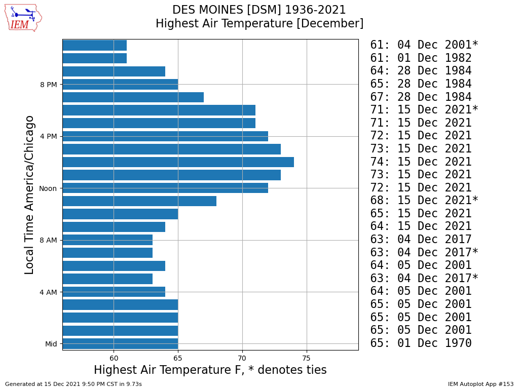
16 Dec 2021 05:31 AM
It feels like it will take the rest of the year to cover all the wild events on 15 December with IEM Daily Features. First up is covering the extremely warm temperatures with most locations in the state setting new all-time record high temperatures for the month of December. While not an official statistic, the IEM computes hourly maximum values based on available data. The featured chart presents this for Des Moines and shows a number of records set mostly during the daylight hours along with the overall new high of 74 degrees shown. Just a mind blowing anomalous event and something that many folks will remember and compare with the 2020 Derecho.
Voting: Good - 16 Bad - 0
Tags: dec152021
Generate This Chart on Website
Fri Dec 17, 2021
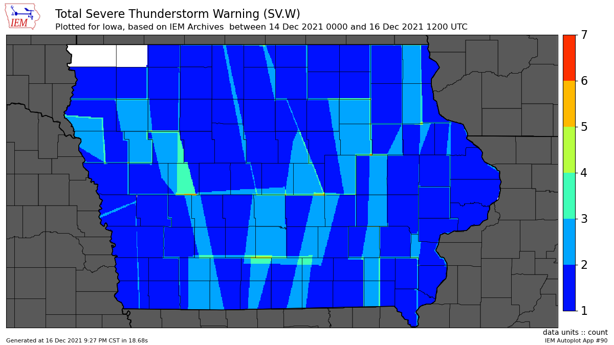
Nearly covered the state
17 Dec 2021 05:31 AM
Having either a Severe Thunderstorm or Tornado Warning during the month of December is very rare. Another way to show how anomalous the events on Wednesday were, the featured map presents a heatmap of polygon Severe Thunderstorm Warnings issued for the event by the NWS. Outside of the two far NW Iowa counties, the entire state was covered by at least one warning. This plot does not include the numerous Tornado Warnings issued as well. It continues to just blow the mind that the most active severe weather day this state saw this year happened during December! Unfortunately, there was a lot of damage associated with the extreme winds that prompted these warnings. Power remains out for thousands of folks with some expected to not regain power for a number of days to come yet.
Voting: Good - 18 Bad - 1
Tags: dec152021
Generate This Chart on Website
Mon Dec 20, 2021
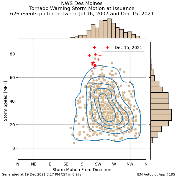
Extreme Storm Motion
20 Dec 2021 05:35 AM
Continuing the theme of highlighting the exceptional weather last Wednesday, today's featured chart presents a climatology of storm motion as specified within NWS Tornado Warnings issued by the Des Moines office. Since 2007, these warnings contain an analyzed storm motion with a travel direction and speed. The featured chart shows all these warning combinations with those from the last event highlighted by a red cross. So while the direction of travel, from approximately the southwest and thus in the northeast direction, was typical for tornado producing storms, the storm speed was anything but typical. Only one other warning on record is shown within the cluster of warnings happening last Wednesday in the 75 to 85 MPH range. Just incredible to see these extreme storm motions with numerous storms that produced confirmed tornadoes and let alone this happening during December!
Voting: Good - 11 Bad - 1
Tags: dec152021
Generate This Chart on Website
Tue Dec 21, 2021
December Derecho
21 Dec 2021 05:34 AM
It is absolutely crazy that Iowa was hit by another Derecho and this time during the month of December. The Storm Prediction Center, which tracks Derecho occurrences, is currently calling the storm system that hit Iowa last Wednesday a "Serial Derecho". The serial portion of the name gets into some meteorology nuance of the event, but the derecho portion of having a long track and long time duration of continuous high wind speeds associated with convection applies. The featured movie presents the combination of NEXRAD mosaic, NWS Severe Thunderstorm / Tornado Warnings, and any thunderstorm related severe wind gusts from Local Storm Reports (LSR)s. The bottom panel attempts to illustrate how continuous in time the reports were as each report is given by a bar of 5 minutes width. You'll notice over ten hours of overlapping bars, which indicates no breaks in the reports.
Voting: Good - 23 Bad - 2
Tags: dec152021
Thu Dec 23, 2021

December Tornado Warnings
23 Dec 2021 06:20 AM
It has been over a week now since the epic events of two Wednesday's ago. The National Weather Service is now up to 42 tornadoes within Iowa that day, which is the largest single day outbreak on record. This event just continues to boggle the mind that this happened during December! The featured chart presents the number of Tornado Warnings issued within Iowa by month since 1986. Again, just crazy to see 36 warnings happening this month and then comparing that to just one total for all previous Decembers and for that total to tie the previous monthly maximum this year during July. May we live in interesting times!
Voting: Good - 15 Bad - 3
Tags: dec152021
Generate This Chart on Website
Mon Dec 27, 2021
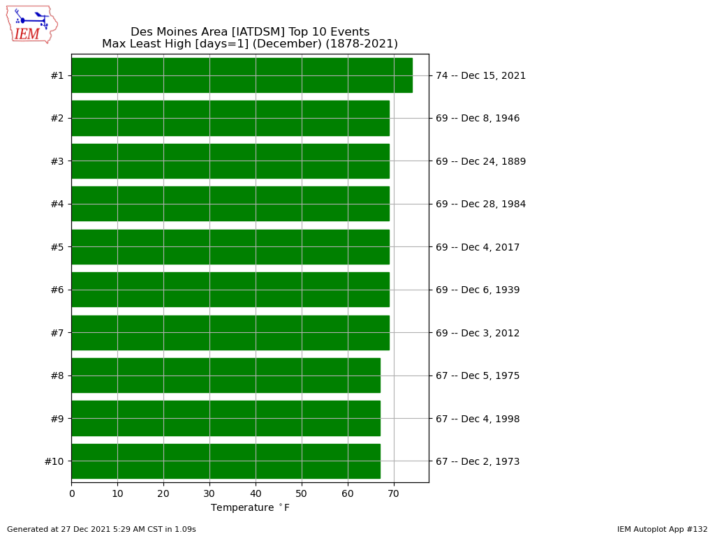
New December Record
27 Dec 2021 05:36 AM
Twelve days after the epic weather events of 15 December and there is still content to feature! The featured chart presents the greatest high temperatures as computed by hourly archives available from the Des Moines Airport during the month of December. The high of 74 is a significant step up from the next warmest value at 69 degrees. Many other sites in the state also established new record high temperatures for the month of December. The overall Iowa statewide record high for the month was likely established as well, but some more time is needed to make that official.
Voting: Good - 7 Bad - 0
Tags: dec152021
Generate This Chart on Website
Tue Dec 28, 2021
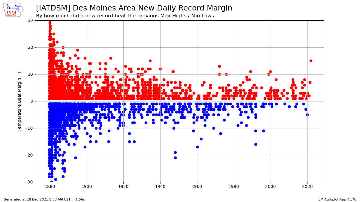
Record Smashing
28 Dec 2021 05:39 AM
When you set an all time December record high temperature, like Des Moines did back on the 15th, of course the daily high record for that day is beat as well. The remarkable aspect of the daily record high temperature beat was the amount greater than the previous record for the date. The featured chart presents the dates over the period of record for Des Moines where a new daily max high or daily min low were established. The previous record was 59 degrees with the new record being 74, so a beat of 15 degrees! The chart indicates this being the largest beat since another 15 degree beat back on 30 May 1934!
Voting: Good - 15 Bad - 0
Tags: dec152021
Generate This Chart on Website
Wed Dec 29, 2021
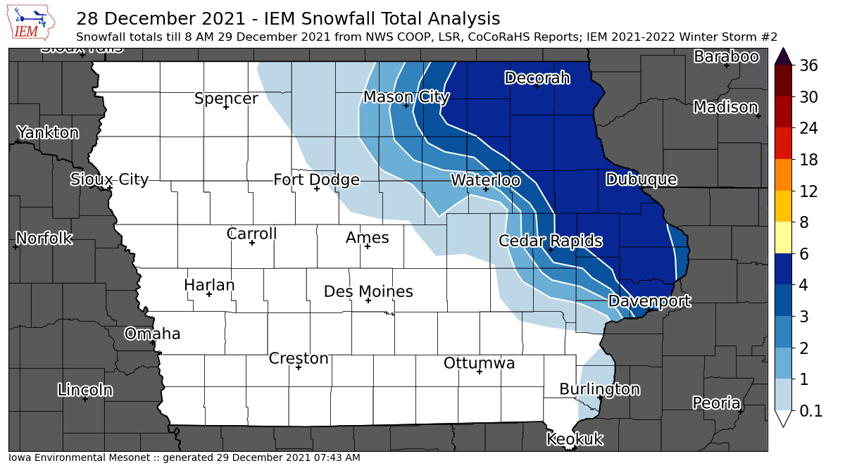
'21-'22 Winter Storm #2
29 Dec 2021 06:39 AM
After the tornadoes and thunderstorms of 15 December, we are now back to full blown winter with activity really picking up this week. The second analyzed winter storm is presented by the featured map with snowfall reports over four inches found over far eastern Iowa. The western gradient for this snowfall appears to have been very tight with significant freezing rain and sleet accumulations found there. The IEM produces these analyses and assigns a sequential number over the winter season. They summarize available NWS Local Storm Reports (LSRs), COOP, and CoCoRaHS reports. The event generally needs to produce at least a few two inch snowfall totals or significant freezing rain totals or have significant travel impacts to be counted. You can find previous storms by clicking on the tag "winter2122" for this event or the "Winter Storms" listing underneath the most popular heading on the homepage.
Voting: Good - 14 Bad - 0
Tags: winter2122
Thu Dec 30, 2021

'21-'22 Winter Storm #3
30 Dec 2021 08:34 AM
While not much for a storm, but the more annoying that anything winter system produced an isolated stripe of 2-4 inches just east and south of Des Moines. Focus continues to be on a blockbuster storm system for the New Year's with heavy snowfall totals possible over Iowa and more severe weather well off to our south and east. Frigid temperatures will also arrive with highs on New Year's Day expected in the single digits and perhaps below zero over northern Iowa.
Voting: Good - 15 Bad - 3
Tags: winter2122