IEM Daily Feature
Wednesday, 15 December 2021
Wednesday, 15 December 2021
Epic 15 December 2021
Posted: 15 Dec 2021 12:04 AM
After the Derecho of 10 August 2020 rewrote Iowa's weather history book last year and the generally
quiet severe weather season this year, one maybe wondered if we could have escaped 2021 without
any memorable events. That no longer appears to be the case with the date of 15 December 2021
likely to go down as very memorable. The weather forecast models and human forecasters are
predicting extreme wind speeds that are difficult to find comparable events with over Iowa's recorded
history. Many folks are wondering how this event will compare with the fresh-in-the-mind Derecho of
last year. The two events are difficult to compare as their meteorology is quite different with a
Derecho being the result of a strong thunderstorm complex and today's event being driven by larger
scale forcing. Additionally, having it happen during December means that there is practically no
vegetation over Iowa's agricultural landscape nor deciduous trees, so near surface wind speeds can
be stronger due to reduced friction. For rough ballpark numbers, the Derecho produced 60-80 MPH
sustained winds with higher gusts over periods around 30 minutes and less. Today's event will
produce 35-50 MPH sustained with gusts in the 50-70 MPH range but over a multiple hour window of
time this evening. The additional concerning threat today will come from any storms that form and
their ability to produce significant tornadoes. Even having such a tornado threat during mid
December is quite remarkable, but this is following a devastating tornado outbreak over the
southeastern US last Friday. Even if these storms do not produce tornadoes, they will surely produce
damaging wind gusts above and beyond what is being experienced without the thunderstorms
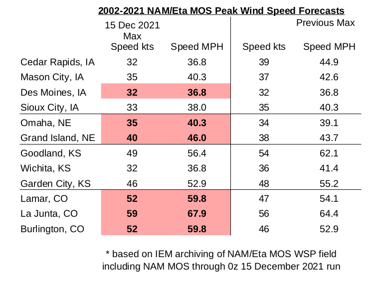
present. The featured infographic displays a nuanced summary of forecast sustained wind speeds
by a forecast system associated with the NAM model called NAM MOS. The IEM has an archive of
this data since 2002 and a number of locations shown have a forecast value above anything
previously on record. Oh, we have not even mentioned yet that today may be memorable for
establishing new all-time December high temperatures and maximum dew point readings. The
threats today are strong winds, storms with stronger winds / maybe tornadoes, and then even
stronger winds overnight. Hunker down!
Voting:
Good = 35
Bad = 0
Tags: dec152021
Voting:
Good = 35
Bad = 0
Tags: dec152021