IEM Daily Feature
Friday, 20 December 2013
Friday, 20 December 2013
Freezing Rain Profiles
Posted: 20 Dec 2013 05:39 AM
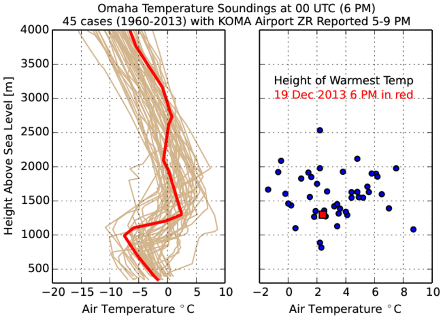
Much of Iowa experienced freezing rain on Thursday evening and into Friday morning.
Freezing rain happens when liquid water, in the form of rain, is able to reach the surface
and then freeze as the physical surface and air temperature are both below freezing. In this
situation, the layer of below freezing air temperature needs to be shallow otherwise the rain
drops will freeze and hit the ground as sleet. The featured chart looks lower atmosphere
soundings from the Omaha site during events of freezing rain reported at the Omaha
Airport. The cases shown depict the classic freezing rain signature of having a shallow
layer of freezing temperature air near the surface with another layer of above freezing
temperature air above it. The left hand plot presents the profile of temperature for the 45
cases used in this analysis, including the event from Thursday evening. The right hand
plot depicts the level of the warmest temperature for each of those cases. The warm layer
of air is centered just a few thousand feet above the ground at temperatures typically
above freezing. What would be snow falls into this warm layer, melts and reaches the
ground as liquid water. Note: since the case selection was based off of automated data,
some of the profiles shown may not have been producing freezing rain.
Voting:
Good = 83
Bad = 16
Abstain = 12
Tags: freezingrain sounding
Voting:
Good = 83
Bad = 16
Abstain = 12
Tags: freezingrain sounding